Account: R0018288
April 1, 2026
| Account | Parcel | Account Type | Tax Year | Buildings | Actual Value | Local Govt Assessed Value | School Assessed Value |
|---|---|---|---|---|---|---|---|
| R0018288 | 070931300014 | Commercial | 2026 | 1 | 1,080,939 | 291,850 | 291,850 |
| Legal |
|---|
| 14076-A PT SE4SW4 31 7 65 BEG S4 COR SEC W84.18' TO TRUE POB N16D26'W 344.56' N73D33'E 22.5' N16D26'W 172.4' S73D33'W 126.3' S16D26'E 483.5' S88D34'E 109.05' TO POB LOT A REC EXEMPT RE-1026 |
| Subdivision | Block | Lot | Land Economic Area |
|---|---|---|---|
| EATON IND I-2 SMALL LOTS |
| Property Address | Property City | Section | Township | Range |
|---|---|---|---|---|
| 99 FACTORY RD | EATON | 31 | 07 | 65 |
| Account | Parcel | Account Type | Tax Year | Buildings | Actual Value | Local Govt Assessed Value | School Assessed Value |
|---|---|---|---|---|---|---|---|
| R0018288 | 070931300014 | Commercial | 2026 | 1 | 1,080,939 | 291,850 | 291,850 |
| Account | Owner Name | Address |
|---|---|---|
| R0018288 | AMALGAMATED SUGAR COMPANY | 1951 S SATURN WAY STE 100 BOISE, ID 837092924 |
| Account | Parcel | Account Type | Tax Year | Buildings | Actual Value | Local Govt Assessed Value | School Assessed Value |
|---|---|---|---|---|---|---|---|
| R0018288 | 070931300014 | Commercial | 2026 | 1 | 1,080,939 | 291,850 | 291,850 |
| Reception | Rec Date | Type | Grantor | Grantee | Doc Fee | Sale Date | Sale Price |
|---|---|---|---|---|---|---|---|
| 2110897 | 08-18-1987 | RE | RECORDED EXEMPTION | RE-1026 | 0.00 | NA | 0 |
| 2110897 | 08-18-1987 | RE | RE-1026 | RE-1026 | 0.00 | 08-18-1987 | 0 |
| 2112047 | 08-27-1987 | SPWD | THOMAS RICHARD F | AMALGAMATED SUGAR CO | 49.00 | 08-20-1987 | 490,000 |
| 2528088 | 01-07-1997 | SWDN | AMALGAMATED SUGAR CO | AMALGAMATED SUGAR CO LLC | 0.00 | 01-07-1997 | 0 |
| 3680188 | 03-10-2010 | SURV | SITE PLAN REVIEW SPR -431 | SITE PLAN REVIEW SPR -431 | 0.00 | 03-10-2010 | 0 |
| 3689551 | 04-28-2010 | SPR | SITE PLAN REVIEW | SPR-431 AM | 0.00 | NA | 0 |
| 3689551 | 04-28-2010 | SURV | SPR 431 AM | SPR 431 AM | 0.00 | 04-28-2010 | 0 |
| 4760841 | 09-28-2021 | OTH | AMALGAMATED SUGAR COMPANY LLC | AMALGAMATED SUGAR COMPANY | 0.00 | 09-27-2021 | 0 |
*If the hyperlink for the reception number does not work, try a manual search in the Clerk and Recorder records. Use the Grantor or Grantee in your search.
| Account | Parcel | Account Type | Tax Year | Buildings | Actual Value | Local Govt Assessed Value | School Assessed Value |
|---|---|---|---|---|---|---|---|
| R0018288 | 070931300014 | Commercial | 2026 | 1 | 1,080,939 | 291,850 | 291,850 |
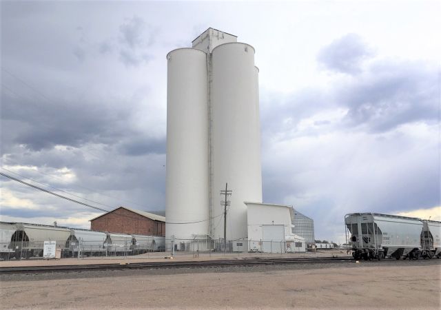
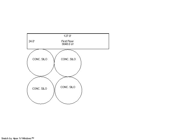
Building 1
| AccountNo | Building ID | Occupancy |
|---|---|---|
| R0018288 | 1 | Grain Elevator Concrete |
| ID | Type | NBHD | Occupancy | % Complete | Bedrooms | Baths |
|---|---|---|---|---|---|---|
| 1 | Out Building | 9801 | Grain Elevator Concrete | 100 | 0 | 0.00 |
| ID | Exterior | Roof Cover | Interior | HVAC | Perimeter | Units | Unit Type | Make |
|---|---|---|---|---|---|---|---|---|
| 1 | NA | NA | NA | None | 0 | 0 | NA | NA |
| ID | Square Ft | Condo SF | Total Basement SF | Finished Basement SF | Garage SF | Carport SF | Balcony SF | Porch SF |
|---|---|---|---|---|---|---|---|---|
| 1 | 1 | 0 | 0 | 0 | 0 | 0 | 0 | 0 |
| ID | Built As | Square Ft | Year Built | Stories | Length | Width |
|---|---|---|---|---|---|---|
| 1.00 | Grain Elevator Concrete | 1 | 1965 | 0 | 0 | 0 |
No Additional Details for Building 1
| Account | Parcel | Account Type | Tax Year | Buildings | Actual Value | Local Govt Assessed Value | School Assessed Value |
|---|---|---|---|---|---|---|---|
| R0018288 | 070931300014 | Commercial | 2026 | 1 | 1,080,939 | 291,850 | 291,850 |
| Type | Code | Description | Actual Value | Local Govt Assessed Value | School Assessed Value | Acres | Land SqFt |
|---|---|---|---|---|---|---|---|
| Improvement | 2235 | WAREHOUSE/STORAGE-IMPS | 830,032 | 224,110 | 224,110 | 0.000 | 0 |
| Land | 2135 | WAREHOUSE/STORAGE-LAND | 250,907 | 67,740 | 67,740 | 1.280 | 55,757 |
| Totals | - | - | 1,080,939 | 291,850 | 291,850 | 1.280 | 55,757 |
Comparable sales for your Residential or Commercial property may be found using our SALES SEARCH TOOL
Values are updated annually on May 1st for Real Property and June 15th for Personal Property and Oil and Gas.
| Account | Parcel | Account Type | Tax Year | Buildings | Actual Value | Local Govt Assessed Value | School Assessed Value |
|---|---|---|---|---|---|---|---|
| R0018288 | 070931300014 | Commercial | 2026 | 1 | 1,080,939 | 291,850 | 291,850 |
| Tax Area | District ID | District Name | Local Govt Mill Levy |
School Mill Levy |
Estimated Taxes |
|---|---|---|---|---|---|
| 5059 | 0700 | AIMS JUNIOR COLLEGE | 6.313 | 0.000 | $1,842.45 |
| 5059 | 0911 | EATON AREA PARK AND RECREATION DISTRICT | 5.425 | 0.000 | $1,583.29 |
| 5059 | 0505 | EATON FIRE | 9.000 | 0.000 | $2,626.65 |
| 5059 | 0403 | EATON TOWN | 5.007 | 0.000 | $1,461.29 |
| 5059 | 1050 | HIGH PLAINS LIBRARY | 3.044 | 0.000 | $888.39 |
| 5059 | 0301 | NORTHERN COLORADO WATER (NCW) | 1.000 | 0.000 | $291.85 |
| 5059 | 0202 | SCHOOL DIST RE2-EATON | 0.000 | 34.206 | $9,983.02 |
| 5059 | 0100 | WELD COUNTY | 15.956 | 0.000 | $4,656.76 |
| Total | - | - | 45.745 | 34.206 | $23,333.70 |
The estimate of tax is based on the prior year mill levy and the 2025 projected assessment rates. Mill levies and tax estimates will be updated yearly on December 22nd for the current year. Additional information can be found at https://assessor.weld.gov