Account: R0093388
April 2, 2026
| Account | Parcel | Account Type | Tax Year | Buildings | Actual Value | Local Govt Assessed Value | School Assessed Value |
|---|---|---|---|---|---|---|---|
| R0093388 | 120723001017 | Commercial | 2026 | 1 | 2,873,440 | 775,830 | 775,830 |
| Legal |
|---|
| SB3-2 L2 BLK3 SEKICH BUSINESS PARK |
| Subdivision | Block | Lot | Land Economic Area |
|---|---|---|---|
| SEKICH BUSINESS PARK | 3 | 2 | MEAD SEKICH, VALLEY 66, LYONS 66 |
| Property Address | Property City | Section | Township | Range |
|---|---|---|---|---|
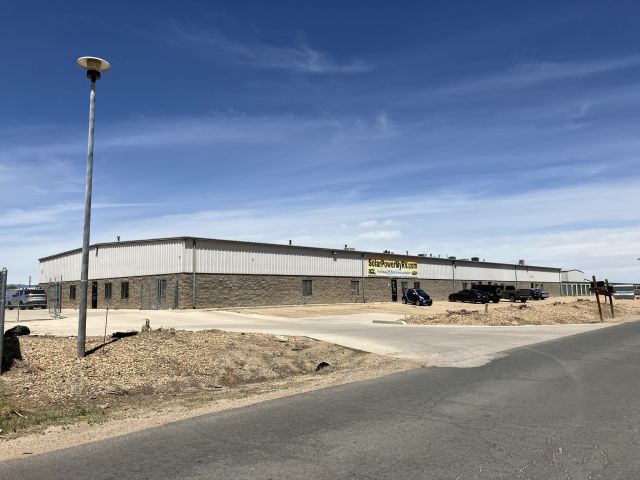
| 14311 MEAD ST | MEAD | 23 | 03 | 68 |
| Account | Parcel | Account Type | Tax Year | Buildings | Actual Value | Local Govt Assessed Value | School Assessed Value |
|---|---|---|---|---|---|---|---|
| R0093388 | 120723001017 | Commercial | 2026 | 1 | 2,873,440 | 775,830 | 775,830 |
| Account | Owner Name | Address |
|---|---|---|
| R0093388 | 14311 MEAD STREET LLC | 14333 MEAD ST LONGMONT, CO 805049649 |
| Account | Parcel | Account Type | Tax Year | Buildings | Actual Value | Local Govt Assessed Value | School Assessed Value |
|---|---|---|---|---|---|---|---|
| R0093388 | 120723001017 | Commercial | 2026 | 1 | 2,873,440 | 775,830 | 775,830 |
| Reception | Rec Date | Type | Grantor | Grantee | Doc Fee | Sale Date | Sale Price |
|---|---|---|---|---|---|---|---|
| 07-02-1987 | SPR | SITE PLAN REVIEW | SPR-87 | 0.00 | NA | 0 | |
| 02102884 | 06-10-1987 | WD | SEKICH FARMS | ONE FORTY THREE ELEVEN (14311) | 11.70 | 06-05-1987 | 117,000 |
| 2102647 | 06-08-1987 | SURV | SURVEY | SURVEY | 0.00 | 06-08-1987 | 0 |
| 2106023 | NA | SUB | SUBDIVISION | SEKICH BUSINESS PARK LOT2 BLK 3 | 0.00 | NA | 0 |
| 2106023 | 07-06-1987 | SURV | SURVEY | SURVEY | 0.00 | 07-06-1987 | 0 |
| 2114173 | 09-11-1987 | SURV | SURVEY | SURVEY | 0.00 | 09-11-1987 | 0 |
| 2300611 | 04-19-1983 | COZ | WELD COUNTY ZONING | CASE: Z-386 ZONING C-3, I-3, PUD | 0.00 | NA | 0 |
| 2632610 | 08-12-1998 | WDN | ONE FORTY THREE ELEVEN (14311) MEAD ST | KOLDEWAY VERN 8.356 INT & | 0.00 | 07-09-1998 | 0 |
| 2632611 | 08-12-1998 | WD | KOLDEWAY VERN 8.356 INT & | KOLDEWAY VERNON E | 5.42 | 08-01-1998 | 54,200 |
| 2632612 | 08-12-1998 | WDN | KOLDEWAY VERN 8.356 INT & | KOLDEWAY VERNON E | 0.00 | 08-01-1998 | 0 |
| 2632613 | 08-12-1998 | WDN | KOLDEWAY VERN 8.356 INT & | KOLDEWAY VERNON E | 0.00 | 08-01-1998 | 0 |
| 2632614 | 08-12-1998 | WDN | KOLDEWAY VERN 8.356 INT & | KOLDEWAY VERNON E | 0.00 | 08-01-1998 | 0 |
| 2632615 | 08-12-1998 | WDN | KOLDEWAY VERN 8.356 INT & | KOLDEWAY VERNON E | 0.00 | 08-01-1998 | 0 |
| 2632616 | 08-12-1998 | WDN | KOLDEWAY VERN 8.356 INT & | KOLDEWAY VERNON E | 0.00 | 08-01-1998 | 0 |
| 2632617 | 08-12-1998 | WDN | KOLDEWAY VERN 8.356 INT & | KOLDEWAY VERNON E | 0.00 | 08-01-1998 | 0 |
| 2632618 | 08-12-1998 | WDN | KOLDEWAY VERN 8.356 INT & | KOLDEWAY VERNON E | 0.00 | 08-01-1998 | 0 |
| 2632619 | 08-12-1998 | WDN | KOLDEWAY VERN 8.356 INT & | KOLDEWAY VERNON E | 0.00 | 08-01-1998 | 0 |
| 4144975 | 09-24-2015 | PRD | KOLDEWAY VERNON E | 14331 MEAD STREET LLC | 195.20 | 09-24-2015 | 1,952,000 |
*If the hyperlink for the reception number does not work, try a manual search in the Clerk and Recorder records. Use the Grantor or Grantee in your search.
| Account | Parcel | Account Type | Tax Year | Buildings | Actual Value | Local Govt Assessed Value | School Assessed Value |
|---|---|---|---|---|---|---|---|
| R0093388 | 120723001017 | Commercial | 2026 | 1 | 2,873,440 | 775,830 | 775,830 |
Building 1
| AccountNo | Building ID | Occupancy |
|---|---|---|
| R0093388 | 1 | Warehouse |
| ID | Type | NBHD | Occupancy | % Complete | Bedrooms | Baths |
|---|---|---|---|---|---|---|
| 1 | Commercial | 3923 | Warehouse | 100 | 0 | 0.00 |
| ID | Exterior | Roof Cover | Interior | HVAC | Perimeter | Units | Unit Type | Make |
|---|---|---|---|---|---|---|---|---|
| 1 | NA | NA | NA | Space Heater | 660 | 0 | NA | NA |
| ID | Square Ft | Condo SF | Total Basement SF | Finished Basement SF | Garage SF | Carport SF | Balcony SF | Porch SF |
|---|---|---|---|---|---|---|---|---|
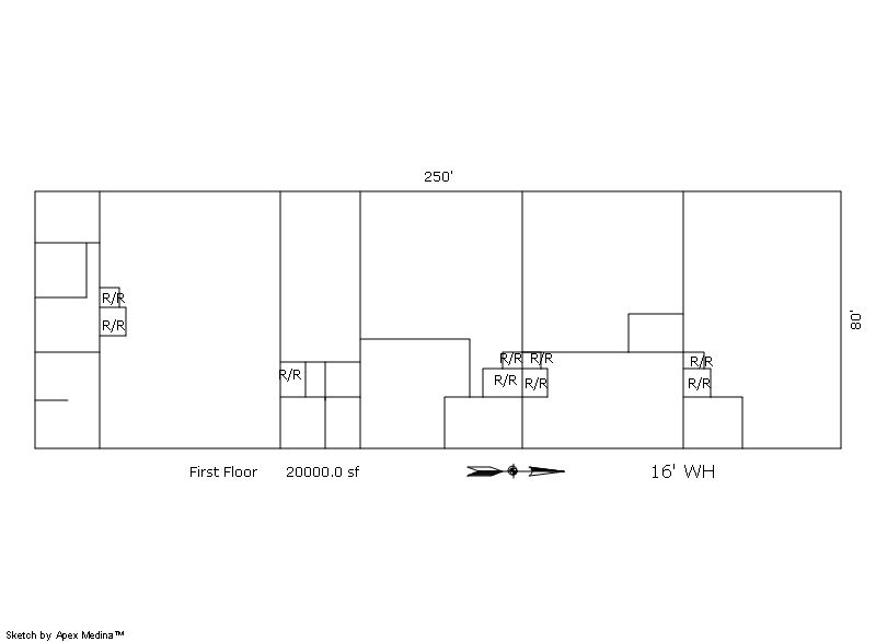
| 1 | 20,000 | 0 | 0 | 0 | 0 | 0 | 0 | 0 |
| ID | Built As | Square Ft | Year Built | Stories | Length | Width |
|---|---|---|---|---|---|---|
| 1.00 | Storage Warehouse | 20,000 | 1988 | 1 | 0 | 0 |
| ID | Detail Type | Description | Units |
|---|---|---|---|
| 1 | Add On | Asphalt | 20500.00 |
| 1 | Add On | Com Office Finish Low | 2925.00 |
| 1 | Add On | Concrete Slab | 3725.00 |
| Account | Parcel | Account Type | Tax Year | Buildings | Actual Value | Local Govt Assessed Value | School Assessed Value |
|---|---|---|---|---|---|---|---|
| R0093388 | 120723001017 | Commercial | 2026 | 1 | 2,873,440 | 775,830 | 775,830 |
| Type | Code | Description | Actual Value | Local Govt Assessed Value | School Assessed Value | Acres | Land SqFt |
|---|---|---|---|---|---|---|---|
| Improvement | 2235 | WAREHOUSE/STORAGE-IMPS | 2,263,600 | 611,170 | 611,170 | 0.000 | 0 |
| Land | 2135 | WAREHOUSE/STORAGE-LAND | 609,840 | 164,660 | 164,660 | 2.000 | 87,120 |
| Totals | - | - | 2,873,440 | 775,830 | 775,830 | 2.000 | 87,120 |
Comparable sales for your Residential or Commercial property may be found using our SALES SEARCH TOOL
Values are updated annually on May 1st for Real Property and June 15th for Personal Property and Oil and Gas.
| Account | Parcel | Account Type | Tax Year | Buildings | Actual Value | Local Govt Assessed Value | School Assessed Value |
|---|---|---|---|---|---|---|---|
| R0093388 | 120723001017 | Commercial | 2026 | 1 | 2,873,440 | 775,830 | 775,830 |
| Tax Area | District ID | District Name | Local Govt Mill Levy |
School Mill Levy |
Estimated Taxes |
|---|---|---|---|---|---|
| 5930 | 1050 | HIGH PLAINS LIBRARY | 3.044 | 0.000 | $2,361.63 |
| 5930 | 0306 | LITTLE THOMPSON WATER (LTW) | 0.000 | 0.000 | $0.00 |
| 5930 | 1202 | LONGMONT CONSERVATION | 0.000 | 0.000 | $0.00 |
| 5930 | 0420 | MEAD TOWN | 11.522 | 0.000 | $8,939.11 |
| 5930 | 0512 | MOUNTAIN VIEW FIRE PROTECTION DISTRICT | 16.342 | 0.000 | $12,678.61 |
| 5930 | 0301 | NORTHERN COLORADO WATER (NCW) | 1.000 | 0.000 | $775.83 |
| 5930 | 0213 | SCHOOL DIST RE1J-LONGMONT | 0.000 | 57.717 | $44,778.58 |
| 5930 | 0303 | ST VRAIN LEFT HAND WATER (SVW) | 1.406 | 0.000 | $1,090.82 |
| 5930 | 0100 | WELD COUNTY | 15.956 | 0.000 | $12,379.14 |
| Total | - | - | 49.27 | 57.717 | $83,003.72 |
The estimate of tax is based on the prior year mill levy and the 2025 projected assessment rates. Mill levies and tax estimates will be updated yearly on December 22nd for the current year. Additional information can be found at https://assessor.weld.gov