Account: R0132601
April 1, 2026
| Account | Parcel | Account Type | Tax Year | Buildings | Actual Value | Local Govt Assessed Value | School Assessed Value |
|---|---|---|---|---|---|---|---|
| R0132601 | 105917007011 | Residential | 2026 | 1 | 524,983 | 32,820 | 37,020 |
| Legal |
|---|
| JOH 1SF L11 BLK7 STROH FARM FG #1 CORR |
| Subdivision | Block | Lot | Land Economic Area |
|---|---|---|---|
| STROH FARM FG#1 CORR | 7 | 11 | STROH FARM |
| Property Address | Property City | Section | Township | Range |
|---|---|---|---|---|
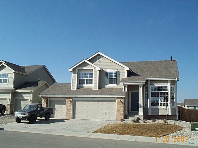
| 1920 WOOD DUCK DR | JOHNSTOWN | 17 | 04 | 67 |
| Account | Parcel | Account Type | Tax Year | Buildings | Actual Value | Local Govt Assessed Value | School Assessed Value |
|---|---|---|---|---|---|---|---|
| R0132601 | 105917007011 | Residential | 2026 | 1 | 524,983 | 32,820 | 37,020 |
| Account | Owner Name | Address |
|---|---|---|
| R0132601 | SEAY JUSTIN | 1920 WOOD DUCK DR JOHNSTOWN, CO 805349265 |
| R0132601 | AGUILAR LINDSEY |
| Account | Parcel | Account Type | Tax Year | Buildings | Actual Value | Local Govt Assessed Value | School Assessed Value |
|---|---|---|---|---|---|---|---|
| R0132601 | 105917007011 | Residential | 2026 | 1 | 524,983 | 32,820 | 37,020 |
| Reception | Rec Date | Type | Grantor | Grantee | Doc Fee | Sale Date | Sale Price |
|---|---|---|---|---|---|---|---|
| 2811421 | NA | SUB | SUBDIVISION | STROH FARM FG #1 | 0.00 | NA | 0 |
| 2998392 | 10-23-2002 | WD | RYLAND GROUP INC | STECINA PAUL J & LISA C | 22.56 | 10-22-2002 | 225,600 |
| 3387369 | 05-11-2006 | WD | STECINA PAUL J & | MCRAE JEFFREY F & | 22.80 | 05-08-2006 | 228,000 |
| 3743083 | 01-05-2011 | QCN | MCRAE JEFFREY F | MCRAE YOLANDA YOUTS | 0.00 | 12-30-2010 | 0 |
| 4225082 | 08-04-2016 | WD | MCRAE JEFFREY F; MCRAE YOLAND YOUTS | LONGSON KIM LORRAINE | 32.60 | 07-28-2016 | 326,000 |
| 4489646 | 05-16-2019 | WD | LONGSON KIM LORRAINE | SEAY JUSTIN; AGUILAR LINDSEY | 38.00 | 05-16-2019 | 380,000 |
*If the hyperlink for the reception number does not work, try a manual search in the Clerk and Recorder records. Use the Grantor or Grantee in your search.
| Account | Parcel | Account Type | Tax Year | Buildings | Actual Value | Local Govt Assessed Value | School Assessed Value |
|---|---|---|---|---|---|---|---|
| R0132601 | 105917007011 | Residential | 2026 | 1 | 524,983 | 32,820 | 37,020 |
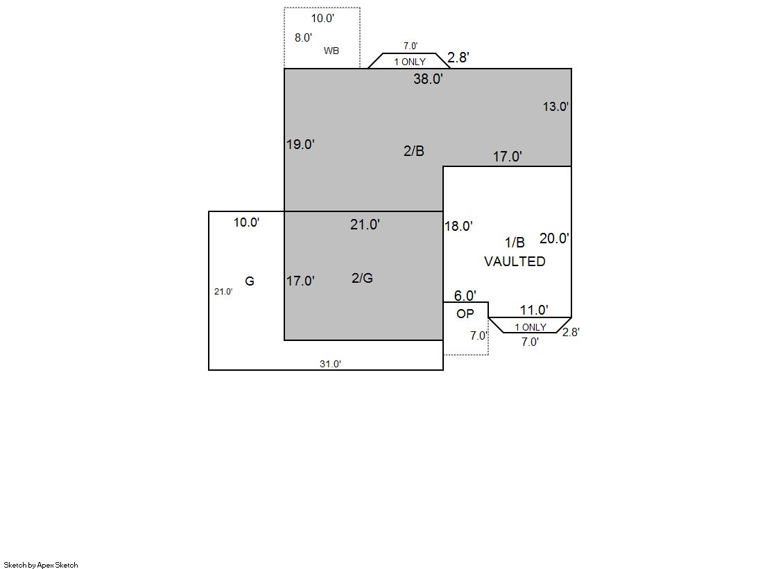
Building 1
| AccountNo | Building ID | Occupancy |
|---|---|---|
| R0132601 | 1 | Single Family Residential |
| ID | Type | NBHD | Occupancy | % Complete | Bedrooms | Baths |
|---|---|---|---|---|---|---|
| 1 | Residential | 0J2083 | Single Family Residential | 100 | 3 | 3.00 |
| ID | Exterior | Roof Cover | Interior | HVAC | Perimeter | Units | Unit Type | Make |
|---|---|---|---|---|---|---|---|---|
| 1 | Frame Hardboard | Composition Shingle | Drywall | Central Air to Air | 337 | 0 | NA | NA |
| ID | Square Ft | Condo SF | Total Basement SF | Finished Basement SF | Garage SF | Carport SF | Balcony SF | Porch SF |
|---|---|---|---|---|---|---|---|---|
| 1 | 1,961 | 0 | 948 | 0 | 651 | 0 | 80 | 42 |
| ID | Built As | Square Ft | Year Built | Stories | Length | Width |
|---|---|---|---|---|---|---|
| 1.00 | 2 Story | 1,961 | 2002 | 2 | 0 | 0 |
| ID | Detail Type | Description | Units |
|---|---|---|---|
| 1 | Balcony | Wood Wood Fin | 80.00 |
| 1 | Basement | Full Daylight | 1.00 |
| 1 | Basement | Total Basement SF | 948.00 |
| 1 | Fixture | Full Bath | 2.00 |
| 1 | Fixture | Half Bath | 1.00 |
| 1 | Garage | Attached | 651.00 |
| 1 | Porch | Slab Roof Ceil | 42.00 |
| 1 | Rough In | Rough In | 1.00 |
| Account | Parcel | Account Type | Tax Year | Buildings | Actual Value | Local Govt Assessed Value | School Assessed Value |
|---|---|---|---|---|---|---|---|
| R0132601 | 105917007011 | Residential | 2026 | 1 | 524,983 | 32,820 | 37,020 |
| Type | Code | Description | Actual Value | Local Govt Assessed Value | School Assessed Value | Acres | Land SqFt |
|---|---|---|---|---|---|---|---|
| Improvement | 1212 | SINGLE FAMILY RESIDENTIAL IMPROVEMENTS | 374,983 | 23,440 | 26,440 | 0.000 | 0 |
| Land | 1112 | SINGLE FAMILY RESIDENTIAL-LAND | 150,000 | 9,380 | 10,580 | 0.164 | 7,150 |
| Totals | - | - | 524,983 | 32,820 | 37,020 | 0.164 | 7,150 |
Comparable sales for your Residential or Commercial property may be found using our SALES SEARCH TOOL
Values are updated annually on May 1st for Real Property and June 15th for Personal Property and Oil and Gas.
| Account | Parcel | Account Type | Tax Year | Buildings | Actual Value | Local Govt Assessed Value | School Assessed Value |
|---|---|---|---|---|---|---|---|
| R0132601 | 105917007011 | Residential | 2026 | 1 | 524,983 | 32,820 | 37,020 |
| Tax Area | District ID | District Name | Local Govt Mill Levy |
School Mill Levy |
Estimated Taxes |
|---|---|---|---|---|---|
| 0568 | 0700 | AIMS JUNIOR COLLEGE | 6.313 | 0.000 | $207.19 |
| 0568 | 0510 | FRONT RANGE FIRE RESCUE FIRE PROTECTION DISTRICT | 11.483 | 0.000 | $376.87 |
| 0568 | 0414 | JOHNSTOWN TOWN | 23.947 | 0.000 | $785.94 |
| 0568 | 0306 | LITTLE THOMPSON WATER (LTW) | 0.000 | 0.000 | $0.00 |
| 0568 | 0301 | NORTHERN COLORADO WATER (NCW) | 1.000 | 0.000 | $32.82 |
| 0568 | 0205 | SCHOOL DIST RE5J-JOHNSTOWN | 0.000 | 36.271 | $1,342.75 |
| 0568 | 0901 | THOMPSON RIVER REC | 3.594 | 0.000 | $117.96 |
| 0568 | 0100 | WELD COUNTY | 15.956 | 0.000 | $523.68 |
| Total | - | - | 62.293 | 36.271 | $3,387.21 |
The estimate of tax is based on the prior year mill levy and the 2025 projected assessment rates. Mill levies and tax estimates will be updated yearly on December 22nd for the current year. Additional information can be found at https://assessor.weld.gov