Account: R0174589
April 5, 2026
| Account | Parcel | Account Type | Tax Year | Buildings | Actual Value | Local Govt Assessed Value | School Assessed Value |
|---|---|---|---|---|---|---|---|
| R0174589 | 146731005022 | Commercial | 2026 | 1 | 2,173,793 | 586,920 | 586,920 |
| Legal |
|---|
| ERI EA-RA1 L1 ERIE AIR PARK SUB REPLAT A |
| Subdivision | Block | Lot | Land Economic Area |
|---|---|---|---|
| ERIE AIR PARK SUB RPLT A | 1 | ERIE AIR PARK |
| Property Address | Property City | Section | Township | Range |
|---|---|---|---|---|
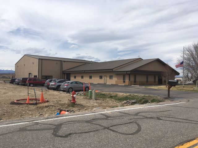
| 2865 AIRPORT DR | ERIE | 31 | 01 | 68 |
| Account | Parcel | Account Type | Tax Year | Buildings | Actual Value | Local Govt Assessed Value | School Assessed Value |
|---|---|---|---|---|---|---|---|
| R0174589 | 146731005022 | Commercial | 2026 | 1 | 2,173,793 | 586,920 | 586,920 |
| Account | Owner Name | Address |
|---|---|---|
| R0174589 | C & K INVESTMENT PROPERTIES LLC | 2865 AIRPORT DR ERIE, CO 805168124 |
| Account | Parcel | Account Type | Tax Year | Buildings | Actual Value | Local Govt Assessed Value | School Assessed Value |
|---|---|---|---|---|---|---|---|
| R0174589 | 146731005022 | Commercial | 2026 | 1 | 2,173,793 | 586,920 | 586,920 |
| Reception | Rec Date | Type | Grantor | Grantee | Doc Fee | Sale Date | Sale Price |
|---|---|---|---|---|---|---|---|
| 02035469 | 12-11-1985 | WDN | 0.00 | 01-01-1900 | 0 | ||
| 2302520 | NA | SUB | SUBDIVISION | ERIE AIR PARK SUB RPLT A | 0.00 | NA | 0 |
| 2529569 | 01-16-1997 | DN | ROCK ROBERT LEE | FEUER JACK D, TRUSTEE | 0.00 | 11-19-1996 | 0 |
| 2643238 | 09-29-1998 | WD | ROCK ROBERT LEE | HAMPEL DAVID | 35.00 | 09-18-1998 | 350,000 |
| 2647424 | 10-19-1998 | QCN | HAMPEL DAVID | HAMPEL DAVID L & LINDA J | 0.00 | 10-13-1998 | 0 |
| 3137224 | 12-19-2003 | QCN | HAMPEL DAVID L & LINDA J | C & K INVESTMENT PROPERTIES LLC | 0.00 | 12-18-2003 | 0 |
*If the hyperlink for the reception number does not work, try a manual search in the Clerk and Recorder records. Use the Grantor or Grantee in your search.
| Account | Parcel | Account Type | Tax Year | Buildings | Actual Value | Local Govt Assessed Value | School Assessed Value |
|---|---|---|---|---|---|---|---|
| R0174589 | 146731005022 | Commercial | 2026 | 1 | 2,173,793 | 586,920 | 586,920 |
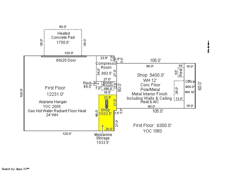
Building 1
| AccountNo | Building ID | Occupancy |
|---|---|---|
| R0174589 | 1 | Warehouse |
| ID | Type | NBHD | Occupancy | % Complete | Bedrooms | Baths |
|---|---|---|---|---|---|---|
| 1 | Commercial | 3901 | Warehouse | 100 | 0 | 0.00 |
| ID | Exterior | Roof Cover | Interior | HVAC | Perimeter | Units | Unit Type | Make |
|---|---|---|---|---|---|---|---|---|
| 1 | NA | NA | NA | Hot Water Radiant | 777 | 0 | NA | NA |
| ID | Square Ft | Condo SF | Total Basement SF | Finished Basement SF | Garage SF | Carport SF | Balcony SF | Porch SF |
|---|---|---|---|---|---|---|---|---|
| 1 | 18,531 | 0 | 0 | 0 | 0 | 0 | 0 | 0 |
| ID | Built As | Square Ft | Year Built | Stories | Length | Width |
|---|---|---|---|---|---|---|
| 1.00 | Industrial Interior Office Space | 900 | 1993 | 1 | 0 | 0 |
| 1.00 | Storage Hangar | 10,057 | 2005 | 1 | 0 | 0 |
| 1.00 | Indust Lght Manufacturing | 5,400 | 1993 | 1 | 0 | 0 |
| 1.00 | Indust Lght Manufacturing | 2,174 | 2005 | 1 | 0 | 0 |
| ID | Detail Type | Description | Units |
|---|---|---|---|
| 1 | Add On | Asphalt Average | 36636.00 |
| 1 | Add On | Concrete Slab Average | 1750.00 |
| 1 | Mezzanine | Storage | 1034.00 |
| Account | Parcel | Account Type | Tax Year | Buildings | Actual Value | Local Govt Assessed Value | School Assessed Value |
|---|---|---|---|---|---|---|---|
| R0174589 | 146731005022 | Commercial | 2026 | 1 | 2,173,793 | 586,920 | 586,920 |
| Type | Code | Description | Actual Value | Local Govt Assessed Value | School Assessed Value | Acres | Land SqFt |
|---|---|---|---|---|---|---|---|
| Improvement | 2235 | WAREHOUSE/STORAGE-IMPS | 1,886,820 | 509,440 | 509,440 | 0.000 | 0 |
| Land | 2135 | WAREHOUSE/STORAGE-LAND | 286,973 | 77,480 | 77,480 | 1.870 | 81,457 |
| Totals | - | - | 2,173,793 | 586,920 | 586,920 | 1.870 | 81,457 |
Comparable sales for your Residential or Commercial property may be found using our SALES SEARCH TOOL
Values are updated annually on May 1st for Real Property and June 15th for Personal Property and Oil and Gas.
| Account | Parcel | Account Type | Tax Year | Buildings | Actual Value | Local Govt Assessed Value | School Assessed Value |
|---|---|---|---|---|---|---|---|
| R0174589 | 146731005022 | Commercial | 2026 | 1 | 2,173,793 | 586,920 | 586,920 |
| Tax Area | District ID | District Name | Local Govt Mill Levy |
School Mill Levy |
Estimated Taxes |
|---|---|---|---|---|---|
| 3207 | 0404 | ERIE TOWN | 13.237 | 0.000 | $7,769.06 |
| 3207 | 1050 | HIGH PLAINS LIBRARY | 3.044 | 0.000 | $1,786.58 |
| 3207 | 0512 | MOUNTAIN VIEW FIRE PROTECTION DISTRICT | 16.342 | 0.000 | $9,591.45 |
| 3207 | 0301 | NORTHERN COLORADO WATER (NCW) | 1.000 | 0.000 | $586.92 |
| 3207 | 1360 | RTD | 0.000 | 0.000 | $0.00 |
| 3207 | 0213 | SCHOOL DIST RE1J-LONGMONT | 0.000 | 57.717 | $33,875.26 |
| 3207 | 0100 | WELD COUNTY | 15.956 | 0.000 | $9,364.90 |
| Total | - | - | 49.579 | 57.717 | $62,974.17 |
The estimate of tax is based on the prior year mill levy and the 2025 projected assessment rates. Mill levies and tax estimates will be updated yearly on December 22nd for the current year. Additional information can be found at https://assessor.weld.gov