Account: R0194587
April 5, 2026
| Account | Parcel | Account Type | Tax Year | Buildings | Actual Value | Local Govt Assessed Value | School Assessed Value |
|---|---|---|---|---|---|---|---|
| R0194587 | 130526321003 | Residential | 2026 | 1 | 508,860 | 31,810 | 35,880 |
| Legal |
|---|
| KEE AAA L2 BLK18 ANITA'S ACRES ADD |
| Subdivision | Block | Lot | Land Economic Area |
|---|---|---|---|
| ANITAS ACRES ADD | 18 | 2 | KEENESBURG SOUTH |
| Property Address | Property City | Section | Township | Range |
|---|---|---|---|---|
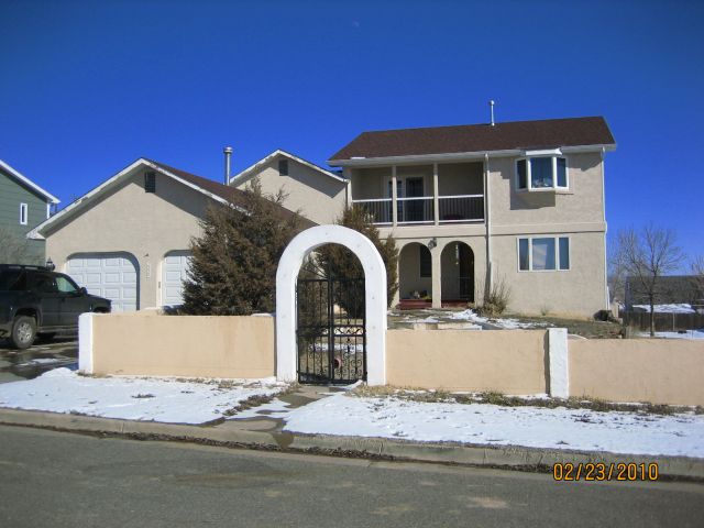
| 550 S PINE ST | KEENESBURG | 26 | 02 | 64 |
| Account | Parcel | Account Type | Tax Year | Buildings | Actual Value | Local Govt Assessed Value | School Assessed Value |
|---|---|---|---|---|---|---|---|
| R0194587 | 130526321003 | Residential | 2026 | 1 | 508,860 | 31,810 | 35,880 |
| Account | Owner Name | Address |
|---|---|---|
| R0194587 | HINES DOUGLAS A | 550 S PINE ST KEENESBURG, CO 806439058 |
| Account | Parcel | Account Type | Tax Year | Buildings | Actual Value | Local Govt Assessed Value | School Assessed Value |
|---|---|---|---|---|---|---|---|
| R0194587 | 130526321003 | Residential | 2026 | 1 | 508,860 | 31,810 | 35,880 |
| Reception | Rec Date | Type | Grantor | Grantee | Doc Fee | Sale Date | Sale Price |
|---|---|---|---|---|---|---|---|
| 02375881 | 03-01-1994 | QCN | 0.00 | 02-17-1994 | 0 | ||
| 2050112 | NA | SUB | SUBDIVISION | ANITAS ACRES ADD | 0.00 | NA | 0 |
| 2055548 | 06-02-1986 | WD | ORR ANITA & VIRGIL | KINNISON SCOTT M & VICKI A | 0.90 | 06-02-1986 | 9,000 |
| 2314015 | 12-09-1992 | WD | KINNISON SCOTT M & VICKI A | FRYE CHARLES DEAN | 8.15 | 12-08-1992 | 81,500 |
| 2572455 | 10-03-1997 | WD | FRYE CHARLES DEAN & LAURA JEAN | COTNER ROBERT R & | 15.30 | 06-30-1997 | 153,000 |
| 3245276 | 12-17-2004 | WD | COTNER ROBERT R & | TRACY BRANDON | 21.50 | 12-08-2004 | 215,000 |
| 4044400 | 09-08-2014 | WD | TRACY BRANDON | HINES DOUGLAS A | 25.00 | 09-05-2014 | 250,000 |
*If the hyperlink for the reception number does not work, try a manual search in the Clerk and Recorder records. Use the Grantor or Grantee in your search.
| Account | Parcel | Account Type | Tax Year | Buildings | Actual Value | Local Govt Assessed Value | School Assessed Value |
|---|---|---|---|---|---|---|---|
| R0194587 | 130526321003 | Residential | 2026 | 1 | 508,860 | 31,810 | 35,880 |
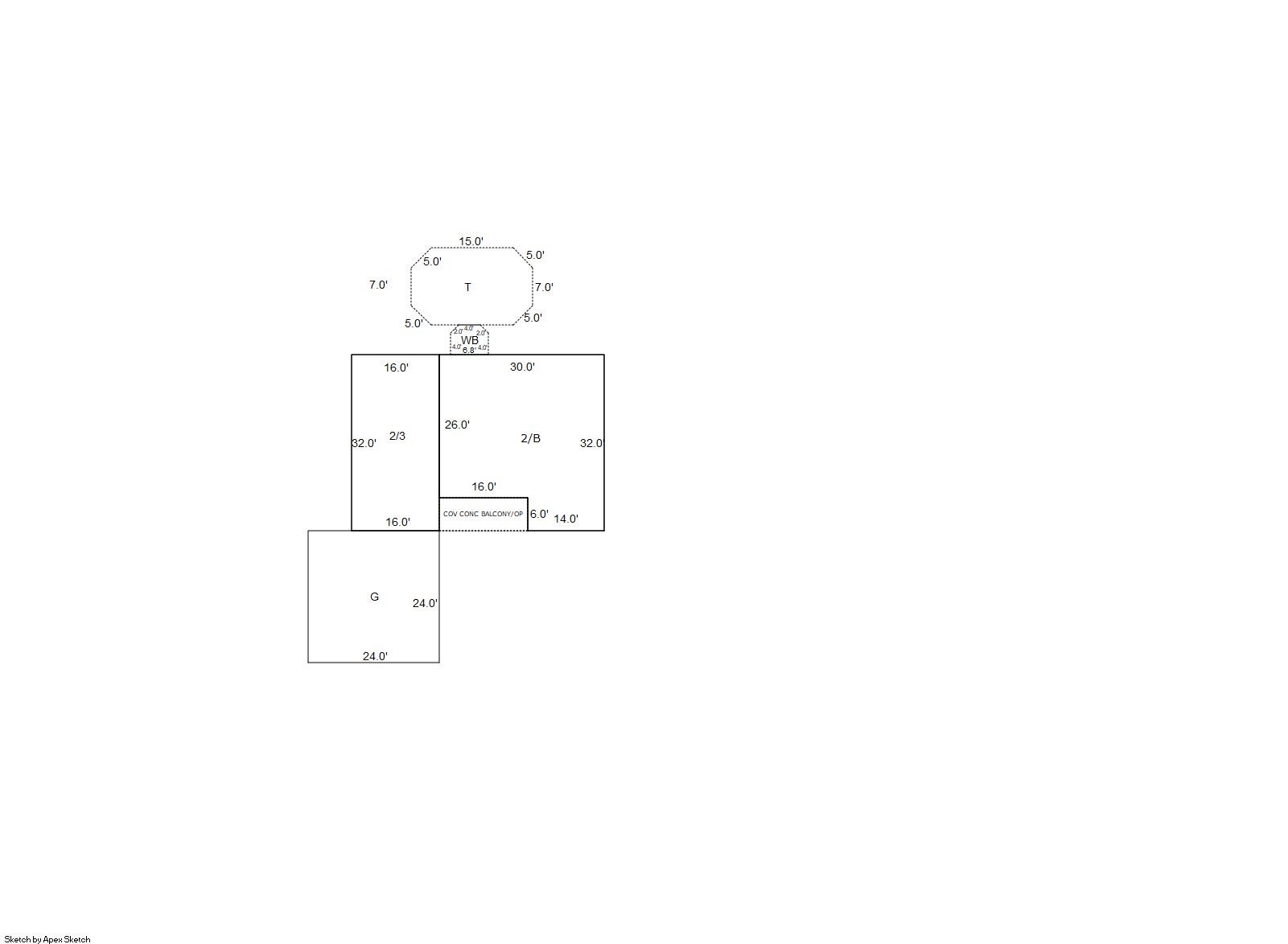
Building 1
| AccountNo | Building ID | Occupancy |
|---|---|---|
| R0194587 | 1 | Single Family Residential |
| ID | Type | NBHD | Occupancy | % Complete | Bedrooms | Baths |
|---|---|---|---|---|---|---|
| 1 | Residential | 5K0007 | Single Family Residential | 100 | 5 | 4.00 |
| ID | Exterior | Roof Cover | Interior | HVAC | Perimeter | Units | Unit Type | Make |
|---|---|---|---|---|---|---|---|---|
| 1 | Frame Stucco | Composition Shingle | Drywall | Hot Water Baseboard | 316 | 0 | NA | NA |
| ID | Square Ft | Condo SF | Total Basement SF | Finished Basement SF | Garage SF | Carport SF | Balcony SF | Porch SF |
|---|---|---|---|---|---|---|---|---|
| 1 | 1,888 | 0 | 864 | 864 | 576 | 0 | 96 | 96 |
| ID | Built As | Square Ft | Year Built | Stories | Length | Width |
|---|---|---|---|---|---|---|
| 1.00 | 2 Story | 1,888 | 1986 | 1 | 0 | 0 |
| ID | Detail Type | Description | Units |
|---|---|---|---|
| 1 | Balcony | Cover Concrete Balc | 96.00 |
| 1 | Balcony | Wood Wood Fin | 35.00 |
| 1 | Basement | Finished | 864.00 |
| 1 | Basement | Total Basement SF | 864.00 |
| 1 | Fixture | Full Bath | 4.00 |
| 1 | Garage | Attached | 576.00 |
| 1 | Porch | Open Slab | 286.00 |
| 1 | Porch | Slab Roof Ceil | 96.00 |
| Account | Parcel | Account Type | Tax Year | Buildings | Actual Value | Local Govt Assessed Value | School Assessed Value |
|---|---|---|---|---|---|---|---|
| R0194587 | 130526321003 | Residential | 2026 | 1 | 508,860 | 31,810 | 35,880 |
| Type | Code | Description | Actual Value | Local Govt Assessed Value | School Assessed Value | Acres | Land SqFt |
|---|---|---|---|---|---|---|---|
| Improvement | 1212 | SINGLE FAMILY RESIDENTIAL IMPROVEMENTS | 441,360 | 27,590 | 31,120 | 0.000 | 0 |
| Land | 1112 | SINGLE FAMILY RESIDENTIAL-LAND | 67,500 | 4,220 | 4,760 | 0.310 | 13,500 |
| Totals | - | - | 508,860 | 31,810 | 35,880 | 0.310 | 13,500 |
Comparable sales for your Residential or Commercial property may be found using our SALES SEARCH TOOL
Values are updated annually on May 1st for Real Property and June 15th for Personal Property and Oil and Gas.
| Account | Parcel | Account Type | Tax Year | Buildings | Actual Value | Local Govt Assessed Value | School Assessed Value |
|---|---|---|---|---|---|---|---|
| R0194587 | 130526321003 | Residential | 2026 | 1 | 508,860 | 31,810 | 35,880 |
| Tax Area | District ID | District Name | Local Govt Mill Levy |
School Mill Levy |
Estimated Taxes |
|---|---|---|---|---|---|
| 0303 | 0700 | AIMS JUNIOR COLLEGE | 6.313 | 0.000 | $200.82 |
| 0303 | 0302 | CENTRAL COLORADO WATER (CCW) | 0.980 | 0.000 | $31.17 |
| 0303 | 1050 | HIGH PLAINS LIBRARY | 3.044 | 0.000 | $96.83 |
| 0303 | 0415 | KEENESBURG TOWN | 22.000 | 0.000 | $699.82 |
| 0303 | 0308 | LOST CREEK GROUNDWATER (LCGW) | 0.945 | 0.000 | $30.06 |
| 0303 | 0518 | S. E. WELD FIRE | 10.470 | 0.000 | $333.05 |
| 0303 | 0203 | SCHOOL DIST RE3J-KEENESBURG | 0.000 | 15.822 | $567.69 |
| 0303 | 0100 | WELD COUNTY | 15.956 | 0.000 | $507.56 |
| Total | - | - | 59.708 | 15.822 | $2,467.00 |
The estimate of tax is based on the prior year mill levy and the 2025 projected assessment rates. Mill levies and tax estimates will be updated yearly on December 22nd for the current year. Additional information can be found at https://assessor.weld.gov