Account: R0217395
April 1, 2026
| Account | Parcel | Account Type | Tax Year | Buildings | Actual Value | Local Govt Assessed Value | School Assessed Value |
|---|---|---|---|---|---|---|---|
| R0217395 | 105908208009 | Residential | 2026 | 1 | 482,659 | 30,160 | 34,030 |
| Legal |
|---|
| JOH 6CA-9 L9 COUNTRY ACRES 6TH FILING |
| Subdivision | Block | Lot | Land Economic Area |
|---|---|---|---|
| COUNTRY ACRES 6TH FG | 9 | COUNTRY ACRES |
| Property Address | Property City | Section | Township | Range |
|---|---|---|---|---|
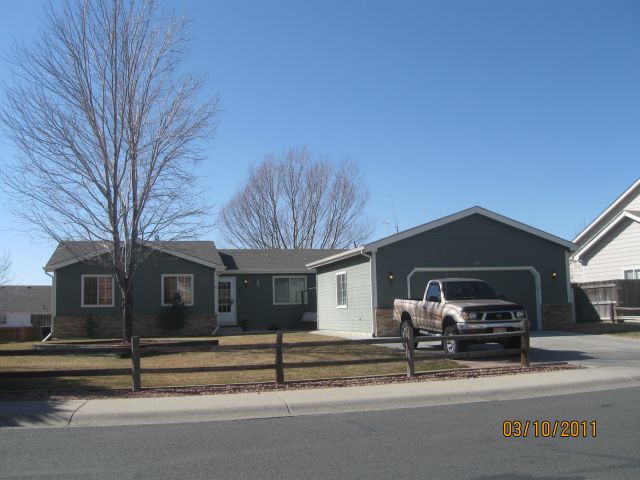
| 1104 COUNTRY ACRES DR | JOHNSTOWN | 08 | 04 | 67 |
| Account | Parcel | Account Type | Tax Year | Buildings | Actual Value | Local Govt Assessed Value | School Assessed Value |
|---|---|---|---|---|---|---|---|
| R0217395 | 105908208009 | Residential | 2026 | 1 | 482,659 | 30,160 | 34,030 |
| Account | Owner Name | Address |
|---|---|---|
| R0217395 | 1104 COUNTRY ACRES DRIVE LLC | 975 W 128TH PL WESTMINSTER, CO 802343835 |
| Account | Parcel | Account Type | Tax Year | Buildings | Actual Value | Local Govt Assessed Value | School Assessed Value |
|---|---|---|---|---|---|---|---|
| R0217395 | 105908208009 | Residential | 2026 | 1 | 482,659 | 30,160 | 34,030 |
| Reception | Rec Date | Type | Grantor | Grantee | Doc Fee | Sale Date | Sale Price |
|---|---|---|---|---|---|---|---|
| 02114777 | 09-17-1987 | QCN | 0.00 | 09-17-1987 | 0 | ||
| 02422446 | 01-10-1995 | QCN | 0.00 | 11-25-1994 | 0 | ||
| 2382684 | NA | SUB | SUBDIVISION | COUNTRY ACRES 6TH FG | 0.00 | NA | 0 |
| 2394137 | 06-20-1994 | WD | CHESTER T HAYS & CO | FULLER JAMES E & | 1.80 | 06-17-1994 | 18,000 |
| 2453085 | 08-28-1995 | WD | FULLER JAMES E | RAAB DAVID J & LISA M | 12.90 | 08-24-1995 | 129,000 |
| 3383480 | 05-01-2006 | QCN | RAAB DAVID J & LISA M | RAAB DAVID J | 0.00 | 04-20-2006 | 0 |
| 4123243 | 07-09-2015 | WD | RAAB DAVID J | SCHOH ROBIN J | 24.25 | 07-08-2015 | 242,500 |
| 4140401 | 09-09-2015 | WDN | SCHOH ROBIN J | 1104 COUNTRY ACRES DRIVE LLC | 0.00 | 09-02-2015 | 0 |
*If the hyperlink for the reception number does not work, try a manual search in the Clerk and Recorder records. Use the Grantor or Grantee in your search.
| Account | Parcel | Account Type | Tax Year | Buildings | Actual Value | Local Govt Assessed Value | School Assessed Value |
|---|---|---|---|---|---|---|---|
| R0217395 | 105908208009 | Residential | 2026 | 1 | 482,659 | 30,160 | 34,030 |
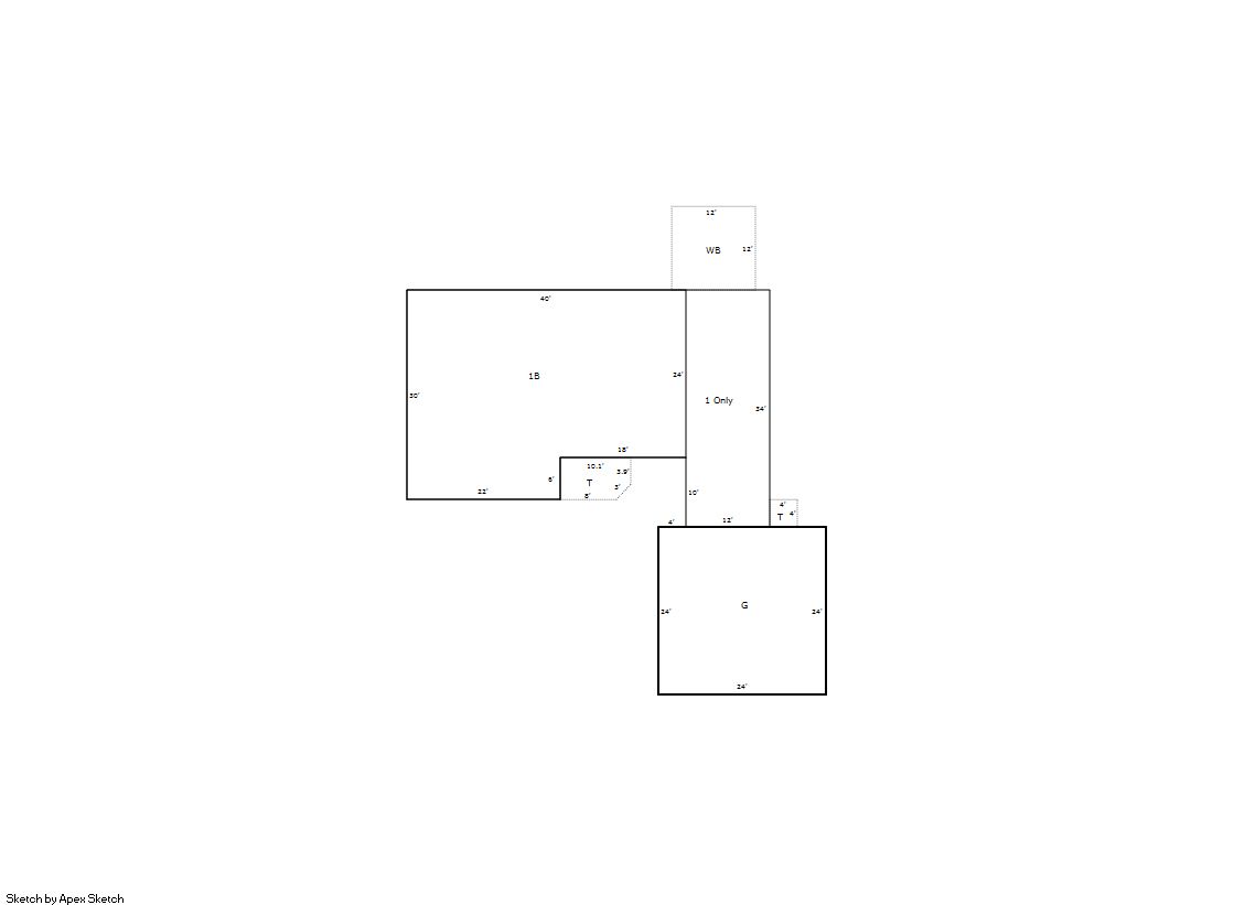
Building 1
| AccountNo | Building ID | Occupancy |
|---|---|---|
| R0217395 | 1 | Single Family Residential |
| ID | Type | NBHD | Occupancy | % Complete | Bedrooms | Baths |
|---|---|---|---|---|---|---|
| 1 | Residential | 0J1077 | Single Family Residential | 100 | 3 | 3.00 |
| ID | Exterior | Roof Cover | Interior | HVAC | Perimeter | Units | Unit Type | Make |
|---|---|---|---|---|---|---|---|---|
| 1 | Frame Hardboard | Composition Shingle | Drywall | Forced Air | 184 | 0 | NA | NA |
| ID | Square Ft | Condo SF | Total Basement SF | Finished Basement SF | Garage SF | Carport SF | Balcony SF | Porch SF |
|---|---|---|---|---|---|---|---|---|
| 1 | 1,500 | 0 | 1,092 | 0 | 576 | 0 | 144 | 74 |
| ID | Built As | Square Ft | Year Built | Stories | Length | Width |
|---|---|---|---|---|---|---|
| 1.00 | Ranch 1 Story | 1,500 | 1995 | 1 | 0 | 0 |
| ID | Detail Type | Description | Units |
|---|---|---|---|
| 1 | Add On | Fireplace Gas | 1.00 |
| 1 | Balcony | Wood Wood Fin | 144.00 |
| 1 | Basement | Total Basement SF | 1092.00 |
| 1 | Fixture | Full Bath | 2.00 |
| 1 | Fixture | Half Bath | 1.00 |
| 1 | Garage | Attached | 576.00 |
| 1 | Porch | Open Slab | 74.00 |
| 1 | Rough In | Rough In | 1.00 |
| Account | Parcel | Account Type | Tax Year | Buildings | Actual Value | Local Govt Assessed Value | School Assessed Value |
|---|---|---|---|---|---|---|---|
| R0217395 | 105908208009 | Residential | 2026 | 1 | 482,659 | 30,160 | 34,030 |
| Type | Code | Description | Actual Value | Local Govt Assessed Value | School Assessed Value | Acres | Land SqFt |
|---|---|---|---|---|---|---|---|
| Improvement | 1212 | SINGLE FAMILY RESIDENTIAL IMPROVEMENTS | 369,659 | 23,100 | 26,060 | 0.000 | 0 |
| Land | 1112 | SINGLE FAMILY RESIDENTIAL-LAND | 113,000 | 7,060 | 7,970 | 0.229 | 9,967 |
| Totals | - | - | 482,659 | 30,160 | 34,030 | 0.229 | 9,967 |
Comparable sales for your Residential or Commercial property may be found using our SALES SEARCH TOOL
Values are updated annually on May 1st for Real Property and June 15th for Personal Property and Oil and Gas.
| Account | Parcel | Account Type | Tax Year | Buildings | Actual Value | Local Govt Assessed Value | School Assessed Value |
|---|---|---|---|---|---|---|---|
| R0217395 | 105908208009 | Residential | 2026 | 1 | 482,659 | 30,160 | 34,030 |
| Tax Area | District ID | District Name | Local Govt Mill Levy |
School Mill Levy |
Estimated Taxes |
|---|---|---|---|---|---|
| 0567 | 0700 | AIMS JUNIOR COLLEGE | 6.313 | 0.000 | $190.40 |
| 0567 | 0510 | FRONT RANGE FIRE RESCUE FIRE PROTECTION DISTRICT | 11.483 | 0.000 | $346.33 |
| 0567 | 0414 | JOHNSTOWN TOWN | 23.947 | 0.000 | $722.24 |
| 0567 | 0301 | NORTHERN COLORADO WATER (NCW) | 1.000 | 0.000 | $30.16 |
| 0567 | 0205 | SCHOOL DIST RE5J-JOHNSTOWN | 0.000 | 36.271 | $1,234.30 |
| 0567 | 0901 | THOMPSON RIVER REC | 3.594 | 0.000 | $108.40 |
| 0567 | 0100 | WELD COUNTY | 15.956 | 0.000 | $481.23 |
| Total | - | - | 62.293 | 36.271 | $3,113.06 |
The estimate of tax is based on the prior year mill levy and the 2025 projected assessment rates. Mill levies and tax estimates will be updated yearly on December 22nd for the current year. Additional information can be found at https://assessor.weld.gov