
Account: R0239086
May 4, 2024
| Account | Parcel | Space | Account Type | Tax Year | Buildings | Actual Value | Assessed Value |
|---|---|---|---|---|---|---|---|
| R0239086 | 029105113004 | Residential | 2024 | 1 | 125,420 | 8,400 |
| Legal |
|---|
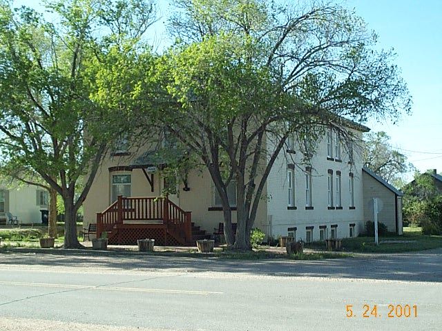
| GRO 5023 L17-18 BLK4 BEATTYS |
| Subdivision | Block | Lot | Land Economic Area |
|---|---|---|---|
| BEATTY ADD | 4 | 17 | GROVER RESIDENTIAL LOTS |
| Property Address | Property City | Zip | Section | Township | Range |
|---|---|---|---|---|---|
| 225 CHATOGA AVE | GROVER | 05 | 10 | 61 |
| Account | Parcel | Space | Account Type | Tax Year | Buildings | Actual Value | Assessed Value |
|---|---|---|---|---|---|---|---|
| R0239086 | 029105113004 | Residential | 2024 | 1 | 125,420 | 8,400 |
| Account | Owner Name | Address |
|---|---|---|
| R0239086 | CARLSTROM BRUCE DAVID | 225 CHATOGA AVE GROVER, CO 80729 |
| Account | Parcel | Space | Account Type | Tax Year | Buildings | Actual Value | Assessed Value |
|---|---|---|---|---|---|---|---|
| R0239086 | 029105113004 | Residential | 2024 | 1 | 125,420 | 8,400 |
| Reception | Rec Date | Type | Grantor | Grantee | Doc Fee | Sale Date | Sale Price |
|---|---|---|---|---|---|---|---|
| 146613 | NA | SUB | SUBDIVISION | BEATTY ADD | 0.00 | NA | 0 |
| 2418244 | 12-07-1994 | WD | SCHOOL DIST #RE-12 | HELD JOYCE ANNETTE | 2.50 | 12-02-1994 | 25,000 |
| 3179200 | 05-11-2004 | WD | HELD JOYCE ANNETTE | OSOSKY MATTHEW D | 11.57 | 05-07-2004 | 115,700 |
| 4501704 | 06-28-2019 | WD | OSOSKY MATTHEW D | CARLSTROM BRUCE DAVID | 9.00 | 06-25-2019 | 90,000 |
*If the hyperlink for the reception number does not work, try a manual search in the Clerk and Recorder records. Use the Grantor or Grantee in your search.
| Account | Parcel | Space | Account Type | Tax Year | Buildings | Actual Value | Assessed Value |
|---|---|---|---|---|---|---|---|
| R0239086 | 029105113004 | Residential | 2024 | 1 | 125,420 | 8,400 |
Building 1
| AccountNo | Building ID | Occupancy |
|---|---|---|
| R0239086 | 1 | Single Family Residential |
| ID | Type | NBHD | Occupancy | % Complete | Bedrooms | Baths | Rooms |
|---|---|---|---|---|---|---|---|
| 1 | Residential | 7001 | Single Family Residential | 100 | 6 | 4 |
| ID | Exterior | Roof Cover | Interior | HVAC | Perimeter | Units | Unit Type | Make |
|---|---|---|---|---|---|---|---|---|
| 1 | Frame Stucco | Flat | Drywall | Electric Baseboard | 1 |
| ID | Square Ft | Condo SF | Total Basement SF | Finished Basement SF | Garage SF | Carport SF | Balcony SF | Porch SF |
|---|---|---|---|---|---|---|---|---|
| 1 | 3,000 | 0 | 1,500 | 0 | 0 | 0 | 0 | 40 |
| ID | Built As | Square Ft | Year Built | Stories | Length | Width |
|---|---|---|---|---|---|---|
| 1.00 | 2 Story | 3,000 | 1900 | 2 | 0 | 0 |
| ID | Detail Type | Description | Units |
|---|---|---|---|
| 1 | Appliance | Allowance | 1 |
| 1 | Basement | Bsmnt Conc 8 ft | 1,500 |
| 1 | Fixture | Allowance | 2 |
| 1 | Fixture | Bath 3 | 4 |
| 1 | Fixture | Water Heater | 2 |
| 1 | Porch | Open Slab | 40 |
| 1 | Porch | Wood Roof | 30 |
| 1 | Rough In | Rough In | 1 |
| Account | Parcel | Space | Account Type | Tax Year | Buildings | Actual Value | Assessed Value |
|---|---|---|---|---|---|---|---|
| R0239086 | 029105113004 | Residential | 2024 | 1 | 125,420 | 8,400 |
| Type | Code | Description | Actual Value | Assessed Value | Acres | Land SqFt |
|---|---|---|---|---|---|---|
| Improvement | 1212 | SINGLE FAMILY RESIDENTIAL IMPROVEMENTS | 106,920 | 7,160 | 0.000 | 0 |
| Land | 1112 | SINGLE FAMILY RESIDENTIAL-LAND | 18,500 | 1,240 | 0.161 | 7,000 |
| Totals | - | - | 125,420 | 8,400 | 0.161 | 7,000 |
Comparable sales for your Residential or Commercial property may be found using our SALES SEARCH TOOL
| Account | Parcel | Space | Account Type | Tax Year | Buildings | Actual Value | Assessed Value |
|---|---|---|---|---|---|---|---|
| R0239086 | 029105113004 | Residential | 2024 | 1 | 125,420 | 8,400 |
| Tax Area | District ID | District Name | Current Mill Levy |
|---|---|---|---|
| 6317 | 0700 | AIMS JUNIOR COLLEGE | 6.336 |
| 6317 | 0412 | GROVER TOWN | 19.286 |
| 6317 | 1050 | HIGH PLAINS LIBRARY | 3.196 |
| 6317 | 0522 | PAWNEE FIRE | 1.250 |
| 6317 | 0212 | SCHOOL DIST RE12-GROVER | 4.992 |
| 6317 | 0377 | UPPER CROW CREEK GROUND WATER MANAGEMENT DISTRICT | 2.000 |
| 6317 | 0100 | WELD COUNTY | 12.024 |
| Total | - | - | 49.084 |


Get additional detail with the Map Search.