Account: R1706002
April 5, 2026
| Account | Parcel | Account Type | Tax Year | Buildings | Actual Value | Local Govt Assessed Value | School Assessed Value |
|---|---|---|---|---|---|---|---|
| R1706002 | 120710101069 | Residential | 2026 | 1 | 642,613 | 40,170 | 45,310 |
| Legal |
|---|
| MEA 1CR L69 COYOTE RUN FG #1 |
| Subdivision | Block | Lot | Land Economic Area |
|---|---|---|---|
| COYOTE RUN SUB | 69 | COYOTE RUN |
| Property Address | Property City | Section | Township | Range |
|---|---|---|---|---|
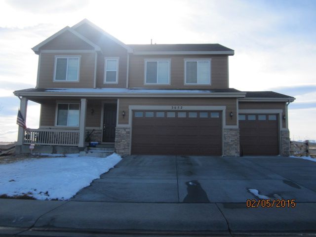
| 3652 DEACON DR | MEAD | 10 | 03 | 68 |
| Account | Parcel | Account Type | Tax Year | Buildings | Actual Value | Local Govt Assessed Value | School Assessed Value |
|---|---|---|---|---|---|---|---|
| R1706002 | 120710101069 | Residential | 2026 | 1 | 642,613 | 40,170 | 45,310 |
| Account | Owner Name | Address |
|---|---|---|
| R1706002 | CAMPBELL PRESTON B | 3652 DEACON DR MEAD, CO 805424560 |
| R1706002 | CAMPBELL LAUREN M |
| Account | Parcel | Account Type | Tax Year | Buildings | Actual Value | Local Govt Assessed Value | School Assessed Value |
|---|---|---|---|---|---|---|---|
| R1706002 | 120710101069 | Residential | 2026 | 1 | 642,613 | 40,170 | 45,310 |
| Reception | Rec Date | Type | Grantor | Grantee | Doc Fee | Sale Date | Sale Price |
|---|---|---|---|---|---|---|---|
| 2951802 | NA | SUB | SUBDIVISION | COYOTE RUN FG #1 | 0.00 | NA | 0 |
| 3023031 | 01-13-2003 | WD | FORRO GERALD J & BARBARA J | US HOME CORPORATION | 125.62 | 01-03-2003 | 1,256,200 |
| 3137736 | 12-22-2003 | WDN | U S HOME CORPORATION | LENNAR COLORADO LLC | 0.00 | 12-19-2003 | 0 |
| 3290368 | 05-31-2005 | SWD | LENNAR COLORADO LLC | ACACIA CREDIT FUND 10 A LLC | 300.00 | 05-25-2005 | 3,000,000 |
| 3527079 | 01-03-2008 | SWD | ACACIA CREDIT FUND 10 A LLC | RHCR LAND ASSOCIATES LLC | 45.55 | 12-31-2007 | 455,500 |
| 3969567 | 10-09-2013 | SWD | RHCR LAND ASSOCIATES LLC | RICHMOND AMERICAN HOMES COLORADO INC | 198.00 | 10-07-2013 | 1,980,000 |
| 4020067 | 06-02-2014 | WD | RICHMOND AMERICAN HOMES COLORADO INC | IM KRISTINE | 38.32 | 05-15-2014 | 383,200 |
| 4419621 | 07-31-2018 | WD | IM KRISTINE; IM CHANG | CARTER MELISSA JOANN; CARTER SYLAS EVAN | 50.50 | 07-24-2018 | 505,000 |
| 4571305 | 03-03-2020 | SWD | CARTER MELISSA JOANN; CARTER SYLAS EVAN | LYMAN JILL S; LYMAN DREW L | 52.51 | 02-27-2020 | 525,100 |
| 4888630 | 03-27-2023 | AFFD | LYMAN JILL S; LYMAN DREW L | LYMAN JILL S; LYMAN DREW L | 0.00 | 02-03-2023 | 0 |
| 4888631 | 03-27-2023 | WD | LYMAN JILL S; LYMAN DREW L | CAMPBELL PRESTON B; CAMPBELL LAUREN M | 65.80 | 02-28-2023 | 658,000 |
*If the hyperlink for the reception number does not work, try a manual search in the Clerk and Recorder records. Use the Grantor or Grantee in your search.
| Account | Parcel | Account Type | Tax Year | Buildings | Actual Value | Local Govt Assessed Value | School Assessed Value |
|---|---|---|---|---|---|---|---|
| R1706002 | 120710101069 | Residential | 2026 | 1 | 642,613 | 40,170 | 45,310 |
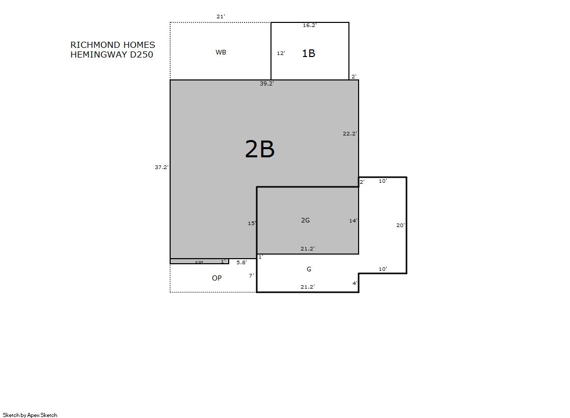
Building 1
| AccountNo | Building ID | Occupancy |
|---|---|---|
| R1706002 | 1 | Single Family Residential |
| ID | Type | NBHD | Occupancy | % Complete | Bedrooms | Baths |
|---|---|---|---|---|---|---|
| 1 | Residential | 3M1063 | Single Family Residential | 100 | 4 | 3.00 |
| ID | Exterior | Roof Cover | Interior | HVAC | Perimeter | Units | Unit Type | Make |
|---|---|---|---|---|---|---|---|---|
| 1 | Frame Hardboard | Composition Shingle | Drywall | Central Air to Air | 332 | 0 | NA | NA |
| ID | Square Ft | Condo SF | Total Basement SF | Finished Basement SF | Garage SF | Carport SF | Balcony SF | Porch SF |
|---|---|---|---|---|---|---|---|---|
| 1 | 2,784 | 0 | 1,335 | 0 | 666 | 0 | 252 | 126 |
| ID | Built As | Square Ft | Year Built | Stories | Length | Width |
|---|---|---|---|---|---|---|
| 1.00 | 2 Story | 2,784 | 2014 | 2 | 0 | 0 |
| ID | Detail Type | Description | Units |
|---|---|---|---|
| 1 | Add On | Fireplace Gas | 1.00 |
| 1 | Balcony | Wood Wood Fin | 252.00 |
| 1 | Basement | Full Daylight | 1.00 |
| 1 | Basement | Total Basement SF | 1335.00 |
| 1 | Fixture | Full Bath | 2.00 |
| 1 | Fixture | Half Bath | 1.00 |
| 1 | Garage | Attached | 666.00 |
| 1 | Porch | Slab Roof Ceil | 126.00 |
| 1 | Rough In | Rough In | 1.00 |
| Account | Parcel | Account Type | Tax Year | Buildings | Actual Value | Local Govt Assessed Value | School Assessed Value |
|---|---|---|---|---|---|---|---|
| R1706002 | 120710101069 | Residential | 2026 | 1 | 642,613 | 40,170 | 45,310 |
| Type | Code | Description | Actual Value | Local Govt Assessed Value | School Assessed Value | Acres | Land SqFt |
|---|---|---|---|---|---|---|---|
| Improvement | 1212 | SINGLE FAMILY RESIDENTIAL IMPROVEMENTS | 504,613 | 31,540 | 35,580 | 0.000 | 0 |
| Land | 1112 | SINGLE FAMILY RESIDENTIAL-LAND | 138,000 | 8,630 | 9,730 | 0.202 | 8,800 |
| Totals | - | - | 642,613 | 40,170 | 45,310 | 0.202 | 8,800 |
Comparable sales for your Residential or Commercial property may be found using our SALES SEARCH TOOL
Values are updated annually on May 1st for Real Property and June 15th for Personal Property and Oil and Gas.
| Account | Parcel | Account Type | Tax Year | Buildings | Actual Value | Local Govt Assessed Value | School Assessed Value |
|---|---|---|---|---|---|---|---|
| R1706002 | 120710101069 | Residential | 2026 | 1 | 642,613 | 40,170 | 45,310 |
| Tax Area | District ID | District Name | Local Govt Mill Levy |
School Mill Levy |
Estimated Taxes |
|---|---|---|---|---|---|
| 1361 | 1050 | HIGH PLAINS LIBRARY | 3.044 | 0.000 | $122.28 |
| 1361 | 0306 | LITTLE THOMPSON WATER (LTW) | 0.000 | 0.000 | $0.00 |
| 1361 | 0420 | MEAD TOWN | 11.522 | 0.000 | $462.84 |
| 1361 | 0512 | MOUNTAIN VIEW FIRE PROTECTION DISTRICT | 16.342 | 0.000 | $656.46 |
| 1361 | 0301 | NORTHERN COLORADO WATER (NCW) | 1.000 | 0.000 | $40.17 |
| 1361 | 0213 | SCHOOL DIST RE1J-LONGMONT | 0.000 | 57.717 | $2,615.16 |
| 1361 | 0303 | ST VRAIN LEFT HAND WATER (SVW) | 1.406 | 0.000 | $56.48 |
| 1361 | 0100 | WELD COUNTY | 15.956 | 0.000 | $640.95 |
| Total | - | - | 49.27 | 57.717 | $4,594.33 |
The estimate of tax is based on the prior year mill levy and the 2025 projected assessment rates. Mill levies and tax estimates will be updated yearly on December 22nd for the current year. Additional information can be found at https://assessor.weld.gov