Account: R2724104
April 5, 2026
| Account | Parcel | Account Type | Tax Year | Buildings | Actual Value | Local Govt Assessed Value | School Assessed Value |
|---|---|---|---|---|---|---|---|
| R2724104 | 120915200036 | Industrial | 2026 | 2 | 166,291 | 44,900 | 44,900 |
| Legal |
|---|
| PT NW4 15-3-67 LOT C REC EXEMPT RE-3621 EXC UPRR RES (4.01R) |
| Subdivision | Block | Lot | Land Economic Area |
|---|---|---|---|
| NW ECON 4 RURAL |
| Property Address | Property City | Section | Township | Range |
|---|---|---|---|---|
| 9290 COUNTY ROAD 34 | WELD | 15 | 03 | 67 |
| Account | Parcel | Account Type | Tax Year | Buildings | Actual Value | Local Govt Assessed Value | School Assessed Value |
|---|---|---|---|---|---|---|---|
| R2724104 | 120915200036 | Industrial | 2026 | 2 | 166,291 | 44,900 | 44,900 |
| Account | Owner Name | Address |
|---|---|---|
| R2724104 | ANADARKO E&P ONSHORE LLC | ATTN: STEVE FISHER LAND SURFACE ROCKIES 1099 18TH ST DENVER, CO 802021908 |
| Account | Parcel | Account Type | Tax Year | Buildings | Actual Value | Local Govt Assessed Value | School Assessed Value |
|---|---|---|---|---|---|---|---|
| R2724104 | 120915200036 | Industrial | 2026 | 2 | 166,291 | 44,900 | 44,900 |
| Reception | Rec Date | Type | Grantor | Grantee | Doc Fee | Sale Date | Sale Price |
|---|---|---|---|---|---|---|---|
| 06-28-1995 | USR | USE BY SPECIAL REVIEW | USR-1063 GAS LINE 24 " | 0.00 | NA | 0 | |
| 07-02-1997 | USR | USE BY SPECIAL REVIEW | USR-1148 PIPELINE12" | 0.00 | NA | 0 | |
| 3126890 | 11-14-2003 | RE | RE-3621 | RE-3621 | 0.00 | 11-14-2003 | 0 |
| 3126890 | 11-14-2003 | RE | RECORDED EXEMPTION | RE-3621 | 0.00 | NA | 0 |
| 3974166 | 10-29-2013 | WD | MAYER FARMS LLC | ANADARKO E&P COMPANY LP | 282.00 | 10-28-2013 | 2,820,000 |
| 4001103 | 03-10-2014 | WDN | MAYER FARMS LLC | ANADARKO E&P ONSHORE LLC | 0.00 | 10-28-2013 | 0 |
| 4054057 | 10-15-2014 | SURV | SURVEY | SURVEY | 0.00 | 10-15-2014 | 0 |
| 4075818 | 01-14-2015 | USR | USE BY SPECIAL REVIEW | USR14-0013 MINERAL RES. DEV. FAC. | 0.00 | NA | 0 |
| 4409714 | 06-25-2018 | USR | SURVEY | SURVEY | 0.00 | 06-25-2018 | 0 |
| 4818675 | 04-13-2022 | USR | USR | USR | 0.00 | 03-22-2022 | 0 |
*If the hyperlink for the reception number does not work, try a manual search in the Clerk and Recorder records. Use the Grantor or Grantee in your search.
| Account | Parcel | Account Type | Tax Year | Buildings | Actual Value | Local Govt Assessed Value | School Assessed Value |
|---|---|---|---|---|---|---|---|
| R2724104 | 120915200036 | Industrial | 2026 | 2 | 166,291 | 44,900 | 44,900 |
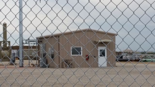
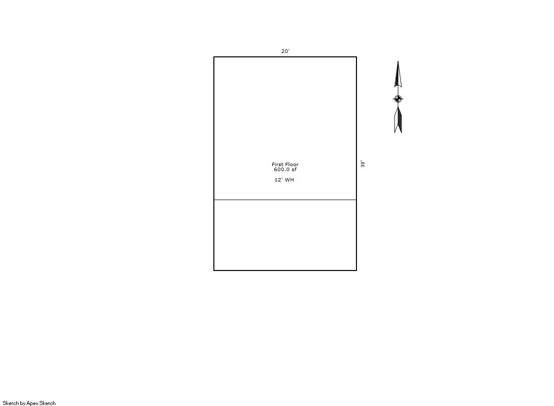
Building 1
| AccountNo | Building ID | Occupancy |
|---|---|---|
| R2724104 | 1 | Warehouse |
| ID | Type | NBHD | Occupancy | % Complete | Bedrooms | Baths |
|---|---|---|---|---|---|---|
| 1 | Commercial | 4901 | Warehouse | 100 | NA | 0.00 |
| ID | Exterior | Roof Cover | Interior | HVAC | Perimeter | Units | Unit Type | Make |
|---|---|---|---|---|---|---|---|---|
| 1 | NA | NA | NA | Complete HVAC | 100 | 0 | NA | NA |
| ID | Square Ft | Condo SF | Total Basement SF | Finished Basement SF | Garage SF | Carport SF | Balcony SF | Porch SF |
|---|---|---|---|---|---|---|---|---|
| 1 | 600 | 0 | 0 | 0 | 0 | 0 | 0 | 0 |
| ID | Built As | Square Ft | Year Built | Stories | Length | Width |
|---|---|---|---|---|---|---|
| 1.00 | Light Commercial Utility | 600 | 2015 | 1 | 0 | 0 |
| ID | Detail Type | Description | Units |
|---|---|---|---|
| 1 | Add On | Chain Link Fence 8ft | 3300.00 |
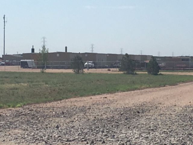
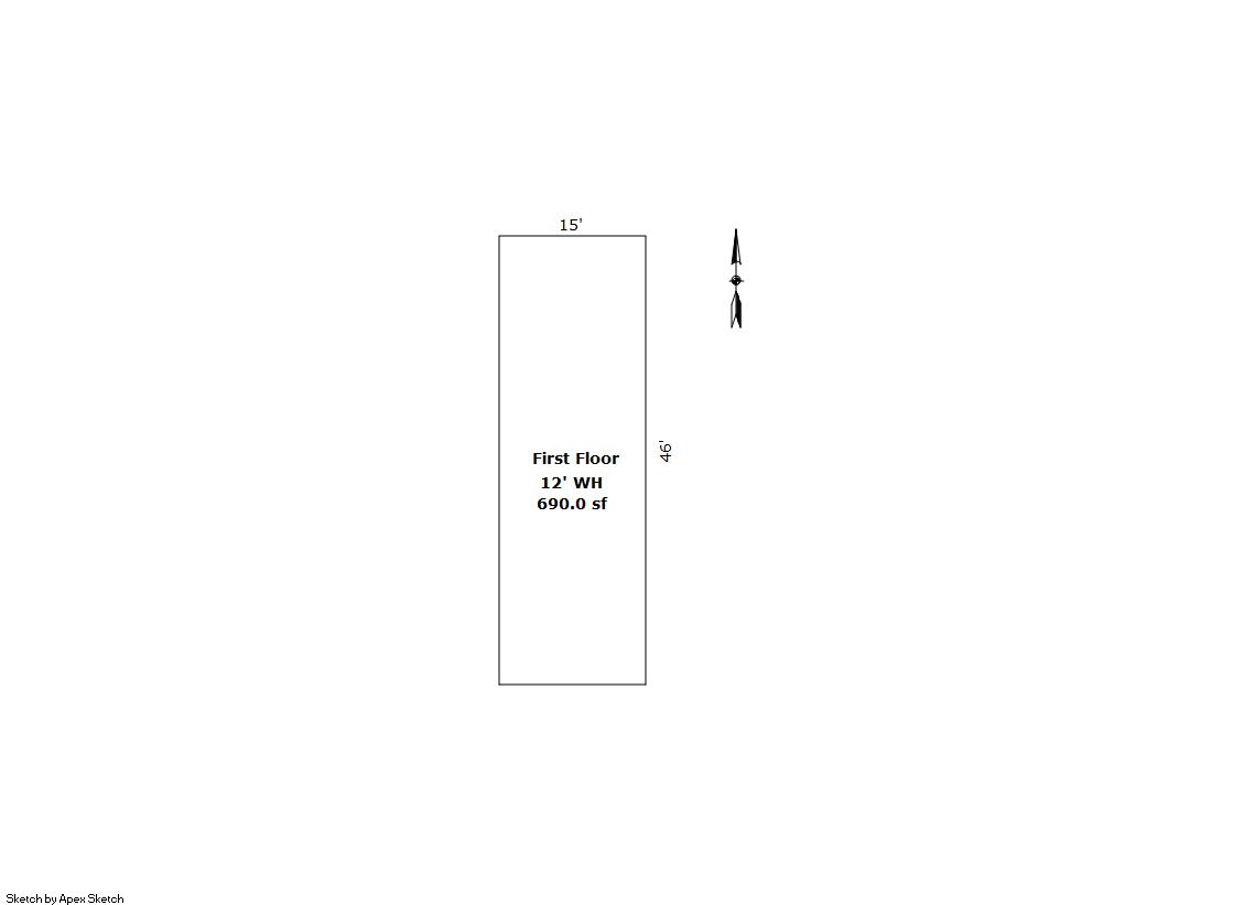
Building 2
| AccountNo | Building ID | Occupancy |
|---|---|---|
| R2724104 | 2 | Warehouse |
| ID | Type | NBHD | Occupancy | % Complete | Bedrooms | Baths |
|---|---|---|---|---|---|---|
| 2 | Commercial | 4901 | Warehouse | 100 | NA | 0.00 |
| ID | Exterior | Roof Cover | Interior | HVAC | Perimeter | Units | Unit Type | Make |
|---|---|---|---|---|---|---|---|---|
| 2 | NA | NA | NA | Complete HVAC | 122 | 0 | NA | NA |
| ID | Square Ft | Condo SF | Total Basement SF | Finished Basement SF | Garage SF | Carport SF | Balcony SF | Porch SF |
|---|---|---|---|---|---|---|---|---|
| 2 | 690 | 0 | 0 | 0 | 0 | 0 | 0 | 0 |
| ID | Built As | Square Ft | Year Built | Stories | Length | Width |
|---|---|---|---|---|---|---|
| 2.00 | Light Commercial Utility | 690 | 2017 | 1 | 46 | 15 |
No Additional Details for Building 2
| Account | Parcel | Account Type | Tax Year | Buildings | Actual Value | Local Govt Assessed Value | School Assessed Value |
|---|---|---|---|---|---|---|---|
| R2724104 | 120915200036 | Industrial | 2026 | 2 | 166,291 | 44,900 | 44,900 |
| Type | Code | Description | Actual Value | Local Govt Assessed Value | School Assessed Value | Acres | Land SqFt |
|---|---|---|---|---|---|---|---|
| Improvement | 3225 | REFINING/PETROLEUM-IMPS | 136,382 | 36,820 | 36,820 | 0.000 | 0 |
| Land | 3125 | REFINING/PETROLEUM-LAND | 20,325 | 5,490 | 5,490 | 4.000 | 174,240 |
| Land | 4127 | DRY FARM LAND-AGRICULTURAL | 9,584 | 2,590 | 2,590 | 112.220 | 4,888,303 |
| Land | 4167 | WASTE LAND | 0 | 0 | 0 | 33.000 | 1,437,480 |
| Totals | - | - | 166,291 | 44,900 | 44,900 | 149.220 | 6,500,023 |
Comparable sales for your Residential or Commercial property may be found using our SALES SEARCH TOOL
Values are updated annually on May 1st for Real Property and June 15th for Personal Property and Oil and Gas.
| Account | Parcel | Account Type | Tax Year | Buildings | Actual Value | Local Govt Assessed Value | School Assessed Value |
|---|---|---|---|---|---|---|---|
| R2724104 | 120915200036 | Industrial | 2026 | 2 | 166,291 | 44,900 | 44,900 |
| Tax Area | District ID | District Name | Local Govt Mill Levy |
School Mill Levy |
Estimated Taxes |
|---|---|---|---|---|---|
| 3052 | 0700 | AIMS JUNIOR COLLEGE | 6.313 | 0.000 | $283.45 |
| 3052 | 0313 | CENTRAL COLO WATER WELL (CCA) | 9.152 | 0.000 | $410.92 |
| 3052 | 0302 | CENTRAL COLORADO WATER (CCW) | 0.980 | 0.000 | $44.00 |
| 3052 | 0305 | CENTRAL WELD COUNTY WATER (CWC) | 0.000 | 0.000 | $0.00 |
| 3052 | 1050 | HIGH PLAINS LIBRARY | 3.044 | 0.000 | $136.68 |
| 3052 | 0301 | NORTHERN COLORADO WATER (NCW) | 1.000 | 0.000 | $44.90 |
| 3052 | 1201 | PLATTE VALLEY CONSERVATION | 0.000 | 0.000 | $0.00 |
| 3052 | 0516 | PLATTEVILLE-GILCREST FIRE | 7.540 | 0.000 | $338.55 |
| 3052 | 0201 | SCHOOL DIST RE1-GILCREST | 0.000 | 15.382 | $690.65 |
| 3052 | 0100 | WELD COUNTY | 15.956 | 0.000 | $716.42 |
| Total | - | - | 43.985 | 15.382 | $2,665.58 |
The estimate of tax is based on the prior year mill levy and the 2025 projected assessment rates. Mill levies and tax estimates will be updated yearly on December 22nd for the current year. Additional information can be found at https://assessor.weld.gov