Account: R2807604
April 2, 2026
| Account | Parcel | Account Type | Tax Year | Buildings | Actual Value | Local Govt Assessed Value | School Assessed Value |
|---|---|---|---|---|---|---|---|
| R2807604 | 105908120006 | Commercial | 2026 | 1 | 5,293,000 | 1,429,110 | 1,429,110 |
| Legal |
|---|
| JOH 1JCCAR L3B-1 JOHNSTOWN CENTER 1ST COMMERCIAL ADD AMD RPLT L3 & 6 LOT LINE ADJ |
| Subdivision | Block | Lot | Land Economic Area |
|---|---|---|---|
| JOHNSTOWN CENTER 1ST COMMERCIAL ADD AM RPLT L3,6 LOT LINE ADJ | 3B1 | JOHNSTOWN COMMERCIAL |
| Property Address | Property City | Section | Township | Range |
|---|---|---|---|---|
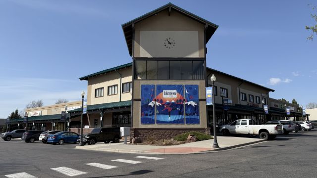
| 257 JOHNSTOWN CENTER DR | JOHNSTOWN | 08 | 04 | 67 |
| Account | Parcel | Account Type | Tax Year | Buildings | Actual Value | Local Govt Assessed Value | School Assessed Value |
|---|---|---|---|---|---|---|---|
| R2807604 | 105908120006 | Commercial | 2026 | 1 | 5,293,000 | 1,429,110 | 1,429,110 |
| Account | Owner Name | Address |
|---|---|---|
| R2807604 | 257 JOHNSTOWN CENTER DRIVE LLC | 1712 TOPAZ DR LOVELAND, CO 805375000 |
| Account | Parcel | Account Type | Tax Year | Buildings | Actual Value | Local Govt Assessed Value | School Assessed Value |
|---|---|---|---|---|---|---|---|
| R2807604 | 105908120006 | Commercial | 2026 | 1 | 5,293,000 | 1,429,110 | 1,429,110 |
| Reception | Rec Date | Type | Grantor | Grantee | Doc Fee | Sale Date | Sale Price |
|---|---|---|---|---|---|---|---|
| 3137247 | NA | SUB | SUBDIVISION | JOHNSTOWN CENTER 1ST COMMERCIAL ADD AMD RPLT LOTS 3 & 6 LOT LINE ADJ | 0.00 | NA | 0 |
| 3137251 | 12-19-2003 | SWD | SYSTEM CAPITAL REAL PROPERTY CORP | JOHNSTOWN STATION DEVELOPMENT GROUP LLC | 42.50 | 12-11-2003 | 425,000 |
| 3357805 | 01-25-2006 | QCN | JOHNSTOWN STATION DEVELOPMENT GROUP LLC | JOHNSTOWN STATION INVESTORS LTD LLLP | 0.00 | 12-14-2005 | 0 |
| 4198451 | 04-26-2016 | SWD | JOHNSTOWN STATION INVESTORS LTD LLLP | TUS NUA LLC | 370.00 | 04-22-2016 | 3,700,000 |
| 5076750 | 01-09-2026 | SWD | TUS NUA LLC | 257 JOHNSTOWN CENTER DRIVE LLC | 525.00 | 01-08-2026 | 5,250,000 |
*If the hyperlink for the reception number does not work, try a manual search in the Clerk and Recorder records. Use the Grantor or Grantee in your search.
| Account | Parcel | Account Type | Tax Year | Buildings | Actual Value | Local Govt Assessed Value | School Assessed Value |
|---|---|---|---|---|---|---|---|
| R2807604 | 105908120006 | Commercial | 2026 | 1 | 5,293,000 | 1,429,110 | 1,429,110 |
Building 1
| AccountNo | Building ID | Occupancy |
|---|---|---|
| R2807604 | 1 | Mixed Retail w/ Office Units |
| ID | Type | NBHD | Occupancy | % Complete | Bedrooms | Baths |
|---|---|---|---|---|---|---|
| 1 | Commercial | 0907 | Mixed Retail w/ Office Units | 100 | 0 | 0.00 |
| ID | Exterior | Roof Cover | Interior | HVAC | Perimeter | Units | Unit Type | Make |
|---|---|---|---|---|---|---|---|---|
| 1 | NA | NA | NA | Package Unit | 800 | 0 | NA | NA |
| ID | Square Ft | Condo SF | Total Basement SF | Finished Basement SF | Garage SF | Carport SF | Balcony SF | Porch SF |
|---|---|---|---|---|---|---|---|---|
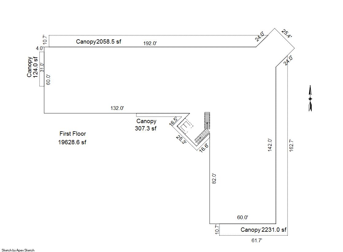
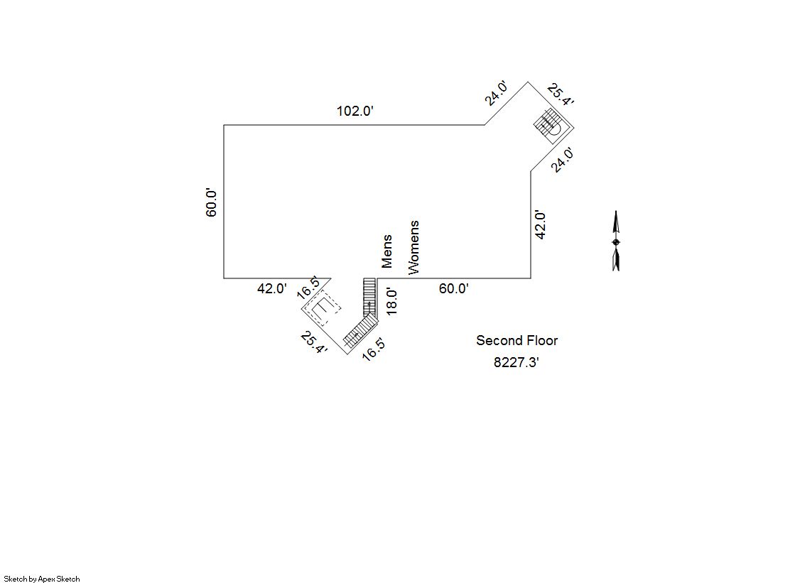
| 1 | 27,856 | 0 | 0 | 0 | 0 | 0 | 0 | 0 |
| ID | Built As | Square Ft | Year Built | Stories | Length | Width |
|---|---|---|---|---|---|---|
| 1.00 | Mixed Retail w/ Office Units | 27,856 | 2005 | 2 | 0 | 0 |
No Additional Details for Building 1
| Account | Parcel | Account Type | Tax Year | Buildings | Actual Value | Local Govt Assessed Value | School Assessed Value |
|---|---|---|---|---|---|---|---|
| R2807604 | 105908120006 | Commercial | 2026 | 1 | 5,293,000 | 1,429,110 | 1,429,110 |
| Type | Code | Description | Actual Value | Local Govt Assessed Value | School Assessed Value | Acres | Land SqFt |
|---|---|---|---|---|---|---|---|
| Improvement | 2212 | MERCHANDISING-IMPROVEMENT | 4,393,630 | 1,186,280 | 1,186,280 | 0.000 | 0 |
| Land | 2112 | MERCHANDISING-LAND | 899,370 | 242,830 | 242,830 | 2.294 | 99,930 |
| Totals | - | - | 5,293,000 | 1,429,110 | 1,429,110 | 2.294 | 99,930 |
Comparable sales for your Residential or Commercial property may be found using our SALES SEARCH TOOL
Values are updated annually on May 1st for Real Property and June 15th for Personal Property and Oil and Gas.
| Account | Parcel | Account Type | Tax Year | Buildings | Actual Value | Local Govt Assessed Value | School Assessed Value |
|---|---|---|---|---|---|---|---|
| R2807604 | 105908120006 | Commercial | 2026 | 1 | 5,293,000 | 1,429,110 | 1,429,110 |
| Tax Area | District ID | District Name | Local Govt Mill Levy |
School Mill Levy |
Estimated Taxes |
|---|---|---|---|---|---|
| 0567 | 0700 | AIMS JUNIOR COLLEGE | 6.313 | 0.000 | $9,021.97 |
| 0567 | 0510 | FRONT RANGE FIRE RESCUE FIRE PROTECTION DISTRICT | 11.483 | 0.000 | $16,410.47 |
| 0567 | 0414 | JOHNSTOWN TOWN | 23.947 | 0.000 | $34,222.90 |
| 0567 | 0301 | NORTHERN COLORADO WATER (NCW) | 1.000 | 0.000 | $1,429.11 |
| 0567 | 0205 | SCHOOL DIST RE5J-JOHNSTOWN | 0.000 | 36.271 | $51,835.25 |
| 0567 | 0901 | THOMPSON RIVER REC | 3.594 | 0.000 | $5,136.22 |
| 0567 | 0100 | WELD COUNTY | 15.956 | 0.000 | $22,802.88 |
| Total | - | - | 62.293 | 36.271 | $140,858.80 |
The estimate of tax is based on the prior year mill levy and the 2025 projected assessment rates. Mill levies and tax estimates will be updated yearly on December 22nd for the current year. Additional information can be found at https://assessor.weld.gov