Account: R4116806
April 4, 2026
| Account | Parcel | Account Type | Tax Year | Buildings | Actual Value | Local Govt Assessed Value | School Assessed Value |
|---|---|---|---|---|---|---|---|
| R4116806 | 146732445051 | Residential | 2026 | 1 | 527,811 | 32,990 | 37,210 |
| Legal |
|---|
| ERI 5VR L51 VISTA RIDGE FG #5 |
| Subdivision | Block | Lot | Land Economic Area |
|---|---|---|---|
| VISTA RIDGE FG#5 FINAL PLAT | 51 | VISTA SMALL LOT |
| Property Address | Property City | Section | Township | Range |
|---|---|---|---|---|
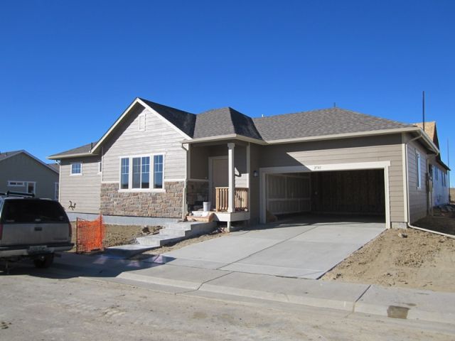
| 2781 DUNDEE PL | ERIE | 32 | 01 | 68 |
| Account | Parcel | Account Type | Tax Year | Buildings | Actual Value | Local Govt Assessed Value | School Assessed Value |
|---|---|---|---|---|---|---|---|
| R4116806 | 146732445051 | Residential | 2026 | 1 | 527,811 | 32,990 | 37,210 |
| Account | Owner Name | Address |
|---|---|---|
| R4116806 | PEPPEL KENDALL G | 2781 DUNDEE PL ERIE, CO 805163647 |
| R4116806 | PEPPEL SHARON A |
| Account | Parcel | Account Type | Tax Year | Buildings | Actual Value | Local Govt Assessed Value | School Assessed Value |
|---|---|---|---|---|---|---|---|
| R4116806 | 146732445051 | Residential | 2026 | 1 | 527,811 | 32,990 | 37,210 |
| Reception | Rec Date | Type | Grantor | Grantee | Doc Fee | Sale Date | Sale Price |
|---|---|---|---|---|---|---|---|
| 3847039 | NA | SUB | SUBDIVISION | VISTA RIDGE FG #5 AMD 2 | 0.00 | NA | 0 |
| 3992956 | 01-29-2014 | SWD | VISTA RIDGE DEVELOPMENT LLC | PEPPEL KENDALL G | 28.46 | 01-28-2014 | 284,600 |
*If the hyperlink for the reception number does not work, try a manual search in the Clerk and Recorder records. Use the Grantor or Grantee in your search.
| Account | Parcel | Account Type | Tax Year | Buildings | Actual Value | Local Govt Assessed Value | School Assessed Value |
|---|---|---|---|---|---|---|---|
| R4116806 | 146732445051 | Residential | 2026 | 1 | 527,811 | 32,990 | 37,210 |
Building 1
| AccountNo | Building ID | Occupancy |
|---|---|---|
| R4116806 | 1 | Single Family Residential |
| ID | Type | NBHD | Occupancy | % Complete | Bedrooms | Baths |
|---|---|---|---|---|---|---|
| 1 | Residential | 3E3016 | Single Family Residential | 100 | 2 | 3.00 |
| ID | Exterior | Roof Cover | Interior | HVAC | Perimeter | Units | Unit Type | Make |
|---|---|---|---|---|---|---|---|---|
| 1 | Frame Hardboard | Composition Shingle | Drywall | Central Air to Air | 0 | 0 | NA | NA |
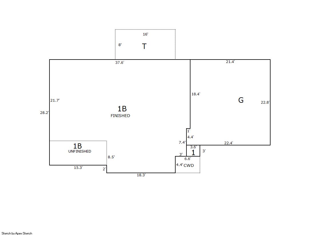
| ID | Square Ft | Condo SF | Total Basement SF | Finished Basement SF | Garage SF | Carport SF | Balcony SF | Porch SF |
|---|---|---|---|---|---|---|---|---|
| 1 | 1,091 | 0 | 1,080 | 980 | 492 | 0 | 0 | 128 |
| ID | Built As | Square Ft | Year Built | Stories | Length | Width |
|---|---|---|---|---|---|---|
| 1.00 | Ranch 1 Story | 1,091 | 2013 | 1 | 0 | 0 |
| ID | Detail Type | Description | Units |
|---|---|---|---|
| 1 | Basement | Finished | 980.00 |
| 1 | Basement | Total Basement SF | 1080.00 |
| 1 | Fixture | Full Bath | 2.00 |
| 1 | Fixture | Half Bath | 1.00 |
| 1 | Garage | Attached | 492.00 |
| 1 | Porch | Cvrd Wood Deck | 29.00 |
| 1 | Porch | Open Slab | 128.00 |
| Account | Parcel | Account Type | Tax Year | Buildings | Actual Value | Local Govt Assessed Value | School Assessed Value |
|---|---|---|---|---|---|---|---|
| R4116806 | 146732445051 | Residential | 2026 | 1 | 527,811 | 32,990 | 37,210 |
| Type | Code | Description | Actual Value | Local Govt Assessed Value | School Assessed Value | Acres | Land SqFt |
|---|---|---|---|---|---|---|---|
| Improvement | 1212 | SINGLE FAMILY RESIDENTIAL IMPROVEMENTS | 418,811 | 26,180 | 29,530 | 0.000 | 0 |
| Land | 1112 | SINGLE FAMILY RESIDENTIAL-LAND | 109,000 | 6,810 | 7,680 | 0.090 | 3,929 |
| Totals | - | - | 527,811 | 32,990 | 37,210 | 0.090 | 3,929 |
Comparable sales for your Residential or Commercial property may be found using our SALES SEARCH TOOL
Values are updated annually on May 1st for Real Property and June 15th for Personal Property and Oil and Gas.
| Account | Parcel | Account Type | Tax Year | Buildings | Actual Value | Local Govt Assessed Value | School Assessed Value |
|---|---|---|---|---|---|---|---|
| R4116806 | 146732445051 | Residential | 2026 | 1 | 527,811 | 32,990 | 37,210 |
| Tax Area | District ID | District Name | Local Govt Mill Levy |
School Mill Levy |
Estimated Taxes |
|---|---|---|---|---|---|
| 3520 | 0404 | ERIE TOWN | 13.237 | 0.000 | $436.69 |
| 3520 | 1050 | HIGH PLAINS LIBRARY | 3.044 | 0.000 | $100.42 |
| 3520 | 0512 | MOUNTAIN VIEW FIRE PROTECTION DISTRICT | 16.342 | 0.000 | $539.12 |
| 3520 | 0301 | NORTHERN COLORADO WATER (NCW) | 1.000 | 0.000 | $32.99 |
| 3520 | 1360 | RTD | 0.000 | 0.000 | $0.00 |
| 3520 | 0213 | SCHOOL DIST RE1J-LONGMONT | 0.000 | 57.717 | $2,147.65 |
| 3520 | 1315 | VISTA RIDGE METRO DISTRICT | 47.000 | 0.000 | $1,550.53 |
| 3520 | 0100 | WELD COUNTY | 15.956 | 0.000 | $526.39 |
| Total | - | - | 96.579 | 57.717 | $5,333.79 |
The estimate of tax is based on the prior year mill levy and the 2025 projected assessment rates. Mill levies and tax estimates will be updated yearly on December 22nd for the current year. Additional information can be found at https://assessor.weld.gov