Account: R4486386
April 1, 2026
| Account | Parcel | Account Type | Tax Year | Buildings | Actual Value | Local Govt Assessed Value | School Assessed Value |
|---|---|---|---|---|---|---|---|
| R4486386 | 105904300010 | Commercial | 2026 | 1 | 349,220 | 94,290 | 94,290 |
| Legal |
|---|
| JOH PT SW4SW4 4-4-67 BEG 69.5'E & 50'N OF SE COR L1 BLK2 JOHNSTOWN E125' N58' W15' N2' W110' S60' TO BEG |
| Subdivision | Block | Lot | Land Economic Area |
|---|---|---|---|
| JOHNSTOWN TOWN | 2 | 1 | JOHNSTOWN COMMERCIAL |
| Property Address | Property City | Section | Township | Range |
|---|---|---|---|---|
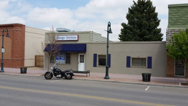
| 9 N PARISH AVE | JOHNSTOWN | 04 | 04 | 67 |
| Account | Parcel | Account Type | Tax Year | Buildings | Actual Value | Local Govt Assessed Value | School Assessed Value |
|---|---|---|---|---|---|---|---|
| R4486386 | 105904300010 | Commercial | 2026 | 1 | 349,220 | 94,290 | 94,290 |
| Account | Owner Name | Address |
|---|---|---|
| R4486386 | EVA AND KATE I LLC | 1968 CATALUNA DR WINDSOR, CO 805503544 |
| Account | Parcel | Account Type | Tax Year | Buildings | Actual Value | Local Govt Assessed Value | School Assessed Value |
|---|---|---|---|---|---|---|---|
| R4486386 | 105904300010 | Commercial | 2026 | 1 | 349,220 | 94,290 | 94,290 |
| Reception | Rec Date | Type | Grantor | Grantee | Doc Fee | Sale Date | Sale Price |
|---|---|---|---|---|---|---|---|
| 01831694 | 07-31-1980 | RITL | 0.00 | 01-01-1900 | 0 | ||
| 3054070 | 04-21-2003 | PRD | STEWART FLORENCE M | GRINE MICHAEL P & BRUNSON KEVIN S | 9.61 | 04-16-2003 | 96,100 |
| 3122552 | 10-31-2003 | QCN | GRINE MICHAEL P & | GRINE MICHAEL P & | 0.00 | 10-29-2003 | 0 |
| 3727186 | 10-22-2010 | QCN | GRINE CAROL ANN | GRINE MICHAEL PAUL | 0.00 | 10-21-2010 | 0 |
| 3830492 | 03-08-2012 | WD | GRINE MICHAEL P | BURGER PATRICIA A | 10.00 | 03-07-2012 | 100,000 |
| 4312062 | 06-21-2017 | WDN | BURGER PATRICIA A | BURGER PATRICIA A TRUST | 0.00 | 04-19-2017 | 0 |
| 4707545 | 04-22-2021 | SWDN | BURGER PATRICIA A TRUST | EVA AND KATE I LLC | 0.00 | 03-29-2021 | 0 |
*If the hyperlink for the reception number does not work, try a manual search in the Clerk and Recorder records. Use the Grantor or Grantee in your search.
| Account | Parcel | Account Type | Tax Year | Buildings | Actual Value | Local Govt Assessed Value | School Assessed Value |
|---|---|---|---|---|---|---|---|
| R4486386 | 105904300010 | Commercial | 2026 | 1 | 349,220 | 94,290 | 94,290 |
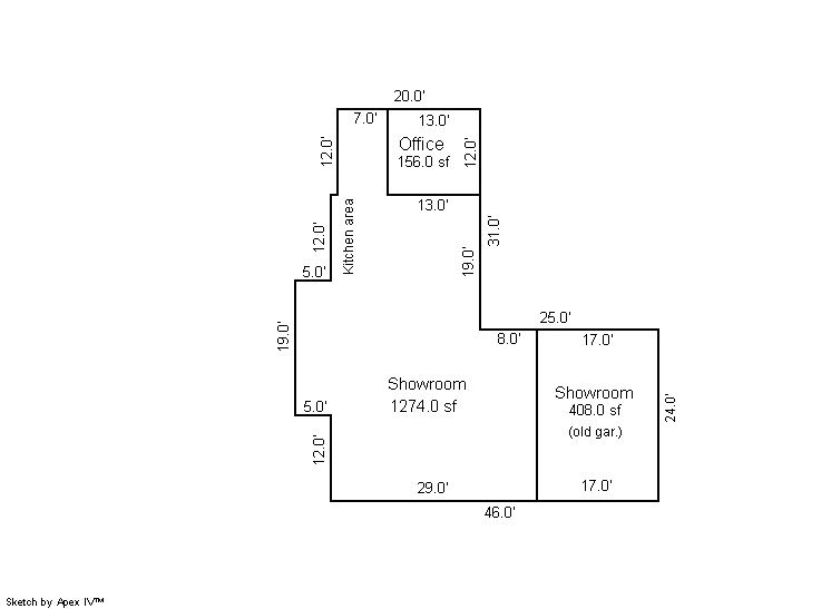
Building 1
| AccountNo | Building ID | Occupancy |
|---|---|---|
| R4486386 | 1 | Retail |
| ID | Type | NBHD | Occupancy | % Complete | Bedrooms | Baths |
|---|---|---|---|---|---|---|
| 1 | Commercial | 0907 | Retail | 100 | 0 | 0.00 |
| ID | Exterior | Roof Cover | Interior | HVAC | Perimeter | Units | Unit Type | Make |
|---|---|---|---|---|---|---|---|---|
| 1 | NA | NA | NA | Forced Air | NA | 0 | NA | NA |
| ID | Square Ft | Condo SF | Total Basement SF | Finished Basement SF | Garage SF | Carport SF | Balcony SF | Porch SF |
|---|---|---|---|---|---|---|---|---|
| 1 | 1,838 | 0 | 0 | 0 | 0 | 0 | 0 | 0 |
| ID | Built As | Square Ft | Year Built | Stories | Length | Width |
|---|---|---|---|---|---|---|
| 1.00 | Retail Store | 1,838 | 1903 | 1 | 0 | 0 |
No Additional Details for Building 1
| Account | Parcel | Account Type | Tax Year | Buildings | Actual Value | Local Govt Assessed Value | School Assessed Value |
|---|---|---|---|---|---|---|---|
| R4486386 | 105904300010 | Commercial | 2026 | 1 | 349,220 | 94,290 | 94,290 |
| Type | Code | Description | Actual Value | Local Govt Assessed Value | School Assessed Value | Acres | Land SqFt |
|---|---|---|---|---|---|---|---|
| Improvement | 2212 | MERCHANDISING-IMPROVEMENT | 304,220 | 82,140 | 82,140 | 0.000 | 0 |
| Land | 2112 | MERCHANDISING-LAND | 45,000 | 12,150 | 12,150 | 0.172 | 7,500 |
| Totals | - | - | 349,220 | 94,290 | 94,290 | 0.172 | 7,500 |
Comparable sales for your Residential or Commercial property may be found using our SALES SEARCH TOOL
Values are updated annually on May 1st for Real Property and June 15th for Personal Property and Oil and Gas.
| Account | Parcel | Account Type | Tax Year | Buildings | Actual Value | Local Govt Assessed Value | School Assessed Value |
|---|---|---|---|---|---|---|---|
| R4486386 | 105904300010 | Commercial | 2026 | 1 | 349,220 | 94,290 | 94,290 |
| Tax Area | District ID | District Name | Local Govt Mill Levy |
School Mill Levy |
Estimated Taxes |
|---|---|---|---|---|---|
| 0567 | 0700 | AIMS JUNIOR COLLEGE | 6.313 | 0.000 | $595.25 |
| 0567 | 0510 | FRONT RANGE FIRE RESCUE FIRE PROTECTION DISTRICT | 11.483 | 0.000 | $1,082.73 |
| 0567 | 0414 | JOHNSTOWN TOWN | 23.947 | 0.000 | $2,257.96 |
| 0567 | 0301 | NORTHERN COLORADO WATER (NCW) | 1.000 | 0.000 | $94.29 |
| 0567 | 0205 | SCHOOL DIST RE5J-JOHNSTOWN | 0.000 | 36.271 | $3,419.99 |
| 0567 | 0901 | THOMPSON RIVER REC | 3.594 | 0.000 | $338.88 |
| 0567 | 0100 | WELD COUNTY | 15.956 | 0.000 | $1,504.49 |
| Total | - | - | 62.293 | 36.271 | $9,293.60 |
The estimate of tax is based on the prior year mill levy and the 2025 projected assessment rates. Mill levies and tax estimates will be updated yearly on December 22nd for the current year. Additional information can be found at https://assessor.weld.gov