Account: R4534486
April 5, 2026
| Account | Parcel | Account Type | Tax Year | Buildings | Actual Value | Local Govt Assessed Value | School Assessed Value |
|---|---|---|---|---|---|---|---|
| R4534486 | 105905424004 | Residential | 2026 | 1 | 436,601 | 27,290 | 30,790 |
| Legal |
|---|
| JOH 21572 L23-24 BLK3 |
| Subdivision | Block | Lot | Land Economic Area |
|---|---|---|---|
| JOHNSTOWN TOWN | 3 | 23 | JOHNSTOWN |
| Property Address | Property City | Section | Township | Range |
|---|---|---|---|---|
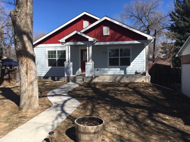
| 25 S RAYMOND AVE | JOHNSTOWN | 05 | 04 | 67 |
| Account | Parcel | Account Type | Tax Year | Buildings | Actual Value | Local Govt Assessed Value | School Assessed Value |
|---|---|---|---|---|---|---|---|
| R4534486 | 105905424004 | Residential | 2026 | 1 | 436,601 | 27,290 | 30,790 |
| Account | Owner Name | Address |
|---|---|---|
| R4534486 | HASELHORST WESLEY A | 25 RAYMOND AVE JOHNSTOWN, CO 805349088 |
| R4534486 | ARTUNDUAGE PATRICIA G CHOQUE |
| Account | Parcel | Account Type | Tax Year | Buildings | Actual Value | Local Govt Assessed Value | School Assessed Value |
|---|---|---|---|---|---|---|---|
| R4534486 | 105905424004 | Residential | 2026 | 1 | 436,601 | 27,290 | 30,790 |
| Reception | Rec Date | Type | Grantor | Grantee | Doc Fee | Sale Date | Sale Price |
|---|---|---|---|---|---|---|---|
| 01788508 | 04-25-1979 | DEC | 0.00 | 01-01-1900 | 0 | ||
| 2959559 | 06-10-2002 | PRD | DEE ELBA E 2/3 INT | JOHNSTOWN FARMS LLC | 210.00 | 05-29-2002 | 2,100,000 |
| 2959560 | 06-10-2002 | WDN | OCONNOR PATRICIA | JOHNSTOWN FARMS LLC | 0.00 | 05-31-2002 | 0 |
| 2959561 | 06-10-2002 | WDN | BECKER JOSEPH D | JOHNSTOWN FARMS LLC | 0.00 | 05-21-2002 | 0 |
| 2959562 | 06-10-2002 | WDN | BECKER RUSSELL M | JOHNSTOWN FARMS LLC | 0.00 | 05-21-2002 | 0 |
| 2959564 | 06-10-2002 | TRUN | BURBANK JANET | JOHNSTOWN FARMS LLC | 0.00 | 05-30-2002 | 0 |
| 3059421 | 05-06-2003 | QCN | JOHNSTOWN FARMS LLC | HOLMAN JOHN L JR & JOHN L III | 0.00 | 04-24-2003 | 0 |
| 3059422 | 05-06-2003 | QCN | JOHNSTOWN FARMS LLC | HOLMAN JOHN L JR & JOHN L III | 0.00 | 04-24-2003 | 0 |
| 3524675 | 12-19-2007 | QCN | NEW FRONTIER BANK | HOLMAN JOHN L JR & | 0.00 | 12-12-2007 | 0 |
| 3524676 | 12-19-2007 | WD | HOLMAN JOHN L JR & | DEROCK CHRISTINE C & | 2.70 | 12-03-2007 | 27,000 |
| 3968983 | 10-07-2013 | WD | DEROCK CHRISTINE C | ROHRBACKER RANDY | 2.20 | 10-04-2013 | 22,000 |
| 4233648 | 09-02-2016 | WD | ROHRBACKER RANDY; ROHRBACKER JULIE | SMITH WADE L | 5.50 | 08-29-2016 | 55,000 |
| 4306713 | 06-01-2017 | WD | SMITH WADE L | HASELHORST WESLEY A; ARTUNDUAGE PATRICIA G CHOQUE | 28.00 | 05-25-2017 | 280,000 |
| 87419 | NA | SUB | SUBDIVISION | JOHNSTOWN | 0.00 | NA | 0 |
*If the hyperlink for the reception number does not work, try a manual search in the Clerk and Recorder records. Use the Grantor or Grantee in your search.
| Account | Parcel | Account Type | Tax Year | Buildings | Actual Value | Local Govt Assessed Value | School Assessed Value |
|---|---|---|---|---|---|---|---|
| R4534486 | 105905424004 | Residential | 2026 | 1 | 436,601 | 27,290 | 30,790 |
Building 1
| AccountNo | Building ID | Occupancy |
|---|---|---|
| R4534486 | 1 | Single Family Residential |
| ID | Type | NBHD | Occupancy | % Complete | Bedrooms | Baths |
|---|---|---|---|---|---|---|
| 1 | Residential | 0J3075 | Single Family Residential | 100 | 2 | 2.00 |
| ID | Exterior | Roof Cover | Interior | HVAC | Perimeter | Units | Unit Type | Make |
|---|---|---|---|---|---|---|---|---|
| 1 | Frame Siding | Composition Shingle | Drywall | Central Air to Air | 132 | 0 | NA | NA |
| ID | Square Ft | Condo SF | Total Basement SF | Finished Basement SF | Garage SF | Carport SF | Balcony SF | Porch SF |
|---|---|---|---|---|---|---|---|---|
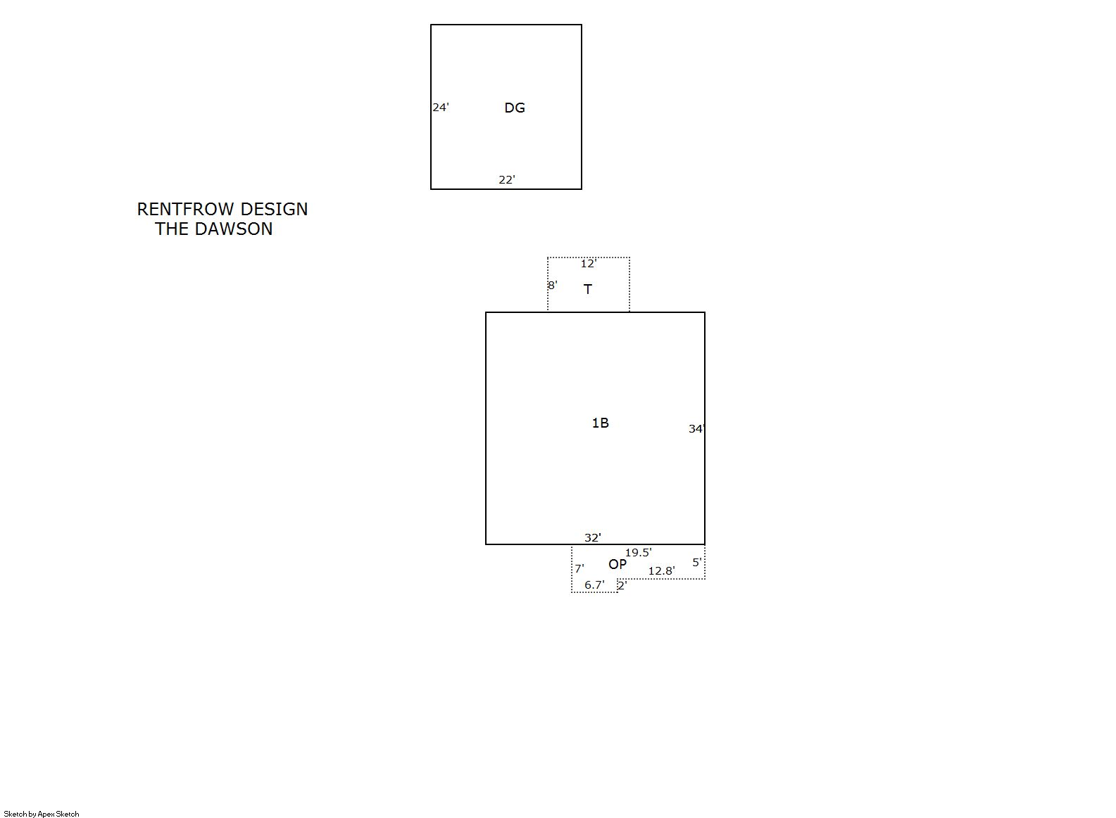
| 1 | 1,088 | 0 | 1,088 | 0 | 528 | 0 | 0 | 96 |
| ID | Built As | Square Ft | Year Built | Stories | Length | Width |
|---|---|---|---|---|---|---|
| 1.00 | Ranch 1 Story | 1,088 | 2017 | 1 | 0 | 0 |
| ID | Detail Type | Description | Units |
|---|---|---|---|
| 1 | Basement | Total Basement SF | 1088.00 |
| 1 | Fixture | Full Bath | 2.00 |
| 1 | Garage | Detached | 528.00 |
| 1 | Porch | Open Slab | 96.00 |
| 1 | Porch | Slab Roof Ceil | 111.00 |
| 1 | Rough In | Rough In | 1.00 |
| Account | Parcel | Account Type | Tax Year | Buildings | Actual Value | Local Govt Assessed Value | School Assessed Value |
|---|---|---|---|---|---|---|---|
| R4534486 | 105905424004 | Residential | 2026 | 1 | 436,601 | 27,290 | 30,790 |
| Type | Code | Description | Actual Value | Local Govt Assessed Value | School Assessed Value | Acres | Land SqFt |
|---|---|---|---|---|---|---|---|
| Improvement | 1212 | SINGLE FAMILY RESIDENTIAL IMPROVEMENTS | 366,601 | 22,910 | 25,850 | 0.000 | 0 |
| Land | 1112 | SINGLE FAMILY RESIDENTIAL-LAND | 70,000 | 4,380 | 4,940 | 0.161 | 7,000 |
| Totals | - | - | 436,601 | 27,290 | 30,790 | 0.161 | 7,000 |
Comparable sales for your Residential or Commercial property may be found using our SALES SEARCH TOOL
Values are updated annually on May 1st for Real Property and June 15th for Personal Property and Oil and Gas.
| Account | Parcel | Account Type | Tax Year | Buildings | Actual Value | Local Govt Assessed Value | School Assessed Value |
|---|---|---|---|---|---|---|---|
| R4534486 | 105905424004 | Residential | 2026 | 1 | 436,601 | 27,290 | 30,790 |
| Tax Area | District ID | District Name | Local Govt Mill Levy |
School Mill Levy |
Estimated Taxes |
|---|---|---|---|---|---|
| 0567 | 0700 | AIMS JUNIOR COLLEGE | 6.313 | 0.000 | $172.28 |
| 0567 | 0510 | FRONT RANGE FIRE RESCUE FIRE PROTECTION DISTRICT | 11.483 | 0.000 | $313.37 |
| 0567 | 0414 | JOHNSTOWN TOWN | 23.947 | 0.000 | $653.51 |
| 0567 | 0301 | NORTHERN COLORADO WATER (NCW) | 1.000 | 0.000 | $27.29 |
| 0567 | 0205 | SCHOOL DIST RE5J-JOHNSTOWN | 0.000 | 36.271 | $1,116.78 |
| 0567 | 0901 | THOMPSON RIVER REC | 3.594 | 0.000 | $98.08 |
| 0567 | 0100 | WELD COUNTY | 15.956 | 0.000 | $435.44 |
| Total | - | - | 62.293 | 36.271 | $2,816.76 |
The estimate of tax is based on the prior year mill levy and the 2025 projected assessment rates. Mill levies and tax estimates will be updated yearly on December 22nd for the current year. Additional information can be found at https://assessor.weld.gov