Account: R4794986
April 1, 2026
| Account | Parcel | Account Type | Tax Year | Buildings | Actual Value | Local Govt Assessed Value | School Assessed Value |
|---|---|---|---|---|---|---|---|
| R4794986 | 120912000008 | Agricultural | 2026 | 2 | 366,216 | 37,600 | 39,970 |
| Legal |
|---|
| 21183 E2NE4 12 3 67 EXC UND IN OG&M (3R) |
| Subdivision | Block | Lot | Land Economic Area |
|---|---|---|---|
| PLATTEVILLE RURAL |
| Property Address | Property City | Section | Township | Range |
|---|---|---|---|---|
| 16757 COUNTY ROAD 25 | WELD | 12 | 03 | 67 |
| Account | Parcel | Account Type | Tax Year | Buildings | Actual Value | Local Govt Assessed Value | School Assessed Value |
|---|---|---|---|---|---|---|---|
| R4794986 | 120912000008 | Agricultural | 2026 | 2 | 366,216 | 37,600 | 39,970 |
| Account | Owner Name | Address |
|---|---|---|
| R4794986 | AGGREGATE INDUSTRIES LAND COMPANY INC | 8700 W BRYN MAWR AVE STE 300 CHICAGO, IL 606313512 |
| Account | Parcel | Account Type | Tax Year | Buildings | Actual Value | Local Govt Assessed Value | School Assessed Value |
|---|---|---|---|---|---|---|---|
| R4794986 | 120912000008 | Agricultural | 2026 | 2 | 366,216 | 37,600 | 39,970 |
| Reception | Rec Date | Type | Grantor | Grantee | Doc Fee | Sale Date | Sale Price |
|---|---|---|---|---|---|---|---|
| 12-19-1996 | USR | USE BY SPECIAL REVIEW | USR-1136 TELECOMM TOWER 120 FT | 0.00 | NA | 0 | |
| 09-08-1999 | USR | USE BY SPECIAL REVIEW | USR-1236 POWER LINES 230/345 KV | 0.00 | NA | 0 | |
| 01877231 | 12-16-1981 | AFFD | 0.00 | 01-01-1900 | 0 | ||
| 02231420 | 10-29-1990 | WDN | 0.00 | 01-01-1900 | 0 | ||
| 2848926 | 05-16-2001 | QCN | BOULTER FRANK L & LEAVY ILA J | BOULTER FRANK L & LEAVY ILA J | 0.00 | 05-15-2001 | 0 |
| 3726332 | 10-19-2010 | PRDN | BOULTER FRANK L ESTATE | BOULTER DAVID S | 0.00 | 10-15-2010 | 0 |
| 3959004 | 08-26-2013 | WDN | BOULTER DAVID S | DB FARMS LLC | 0.00 | 08-21-2013 | 0 |
| 4770277 | 10-27-2021 | SWD | LEAVY ILA J; DB FARMS LLC | CHUGWATER CREEK LLC | 123.60 | 10-27-2021 | 1,236,000 |
| 4770576 | 10-28-2021 | SWD | CHUGWATER CREEK LLC | AGGREGATE INDUSTRIES LAND COMPANY INC | 900.00 | 10-27-2021 | 9,000,000 |
*If the hyperlink for the reception number does not work, try a manual search in the Clerk and Recorder records. Use the Grantor or Grantee in your search.
| Account | Parcel | Account Type | Tax Year | Buildings | Actual Value | Local Govt Assessed Value | School Assessed Value |
|---|---|---|---|---|---|---|---|
| R4794986 | 120912000008 | Agricultural | 2026 | 2 | 366,216 | 37,600 | 39,970 |
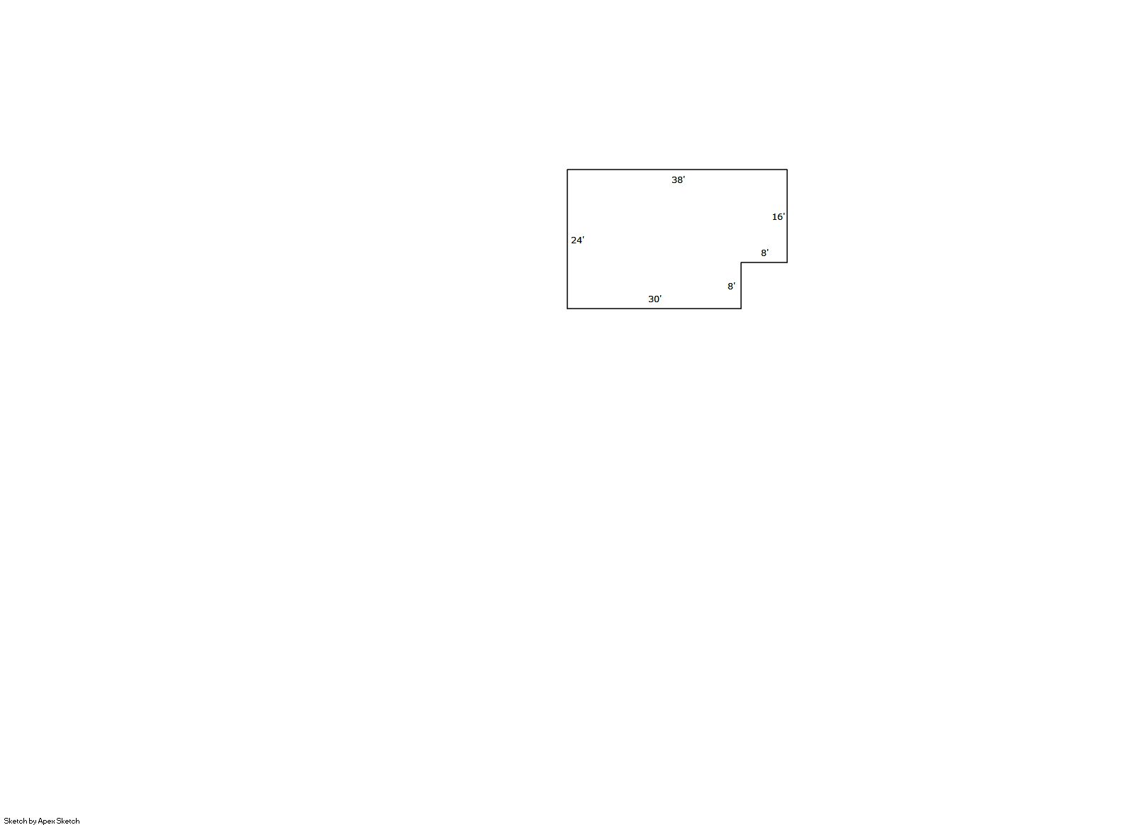
Building 1
| AccountNo | Building ID | Occupancy |
|---|---|---|
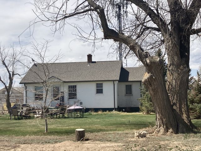
| R4794986 | 1 | Single Family Residential on Ag |
| ID | Type | NBHD | Occupancy | % Complete | Bedrooms | Baths |
|---|---|---|---|---|---|---|
| 1 | Residential | 4R1021 | Single Family Residential on Ag | 100 | 2 | 1.00 |
| ID | Exterior | Roof Cover | Interior | HVAC | Perimeter | Units | Unit Type | Make |
|---|---|---|---|---|---|---|---|---|
| 1 | Frame Masonry Veneer | Composition Shingle | Drywall | None | 124 | 0 | NA | NA |
| ID | Square Ft | Condo SF | Total Basement SF | Finished Basement SF | Garage SF | Carport SF | Balcony SF | Porch SF |
|---|---|---|---|---|---|---|---|---|
| 1 | 848 | 0 | 848 | 0 | 0 | 0 | 0 | 0 |
| ID | Built As | Square Ft | Year Built | Stories | Length | Width |
|---|---|---|---|---|---|---|
| 1.00 | Ranch 1 Story | 848 | 1942 | 1 | 0 | 0 |
| ID | Detail Type | Description | Units |
|---|---|---|---|
| 1 | Basement | Total Basement SF | 848.00 |
| 1 | Fixture | Full Bath | 1.00 |
Building 2
| AccountNo | Building ID | Occupancy |
|---|---|---|
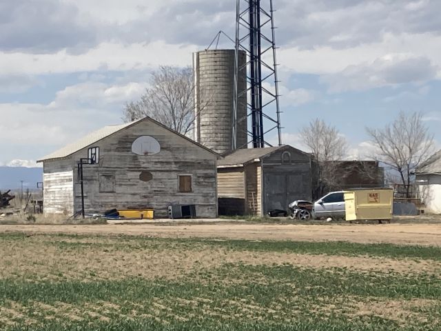
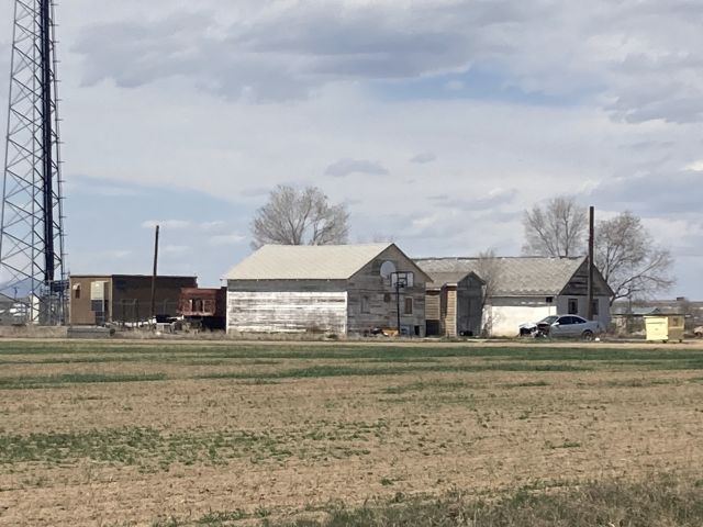
| R4794986 | 2 | Shed - Utility |
| ID | Type | NBHD | Occupancy | % Complete | Bedrooms | Baths |
|---|---|---|---|---|---|---|
| 2 | Out Building | NA | Shed - Utility | 100 | NA | 0.00 |
| ID | Exterior | Roof Cover | Interior | HVAC | Perimeter | Units | Unit Type | Make |
|---|---|---|---|---|---|---|---|---|
| 2 | Pole Frame Metal Siding | NA | NA | None | NA | 0 | NA | NA |
| ID | Square Ft | Condo SF | Total Basement SF | Finished Basement SF | Garage SF | Carport SF | Balcony SF | Porch SF |
|---|---|---|---|---|---|---|---|---|
| 2 | 1 | 0 | 0 | 0 | 0 | 0 | 0 | 0 |
| ID | Built As | Square Ft | Year Built | Stories | Length | Width |
|---|---|---|---|---|---|---|
| 2.00 | Shed - Utility | 1 | 0 | 1 | 0 | 0 |
No Additional Details for Building 2
| Account | Parcel | Account Type | Tax Year | Buildings | Actual Value | Local Govt Assessed Value | School Assessed Value |
|---|---|---|---|---|---|---|---|
| R4794986 | 120912000008 | Agricultural | 2026 | 2 | 366,216 | 37,600 | 39,970 |
| Type | Code | Description | Actual Value | Local Govt Assessed Value | School Assessed Value | Acres | Land SqFt |
|---|---|---|---|---|---|---|---|
| Improvement | 4277 | FARM/RANCH RESIDENCE-IMPS | 295,279 | 18,450 | 20,820 | 0.000 | 0 |
| Improvement | 4279 | FARM RANCH SUPPORT BLDGS | 1,413 | 380 | 380 | 0.000 | 0 |
| Land | 4117 | FLOOD IRRIGATED LAND-AGRICULTURAL | 69,524 | 18,770 | 18,770 | 77.000 | 3,354,120 |
| Totals | - | - | 366,216 | 37,600 | 39,970 | 77.000 | 3,354,120 |
Comparable sales for your Residential or Commercial property may be found using our SALES SEARCH TOOL
Values are updated annually on May 1st for Real Property and June 15th for Personal Property and Oil and Gas.
| Account | Parcel | Account Type | Tax Year | Buildings | Actual Value | Local Govt Assessed Value | School Assessed Value |
|---|---|---|---|---|---|---|---|
| R4794986 | 120912000008 | Agricultural | 2026 | 2 | 366,216 | 37,600 | 39,970 |
| Tax Area | District ID | District Name | Local Govt Mill Levy |
School Mill Levy |
Estimated Taxes |
|---|---|---|---|---|---|
| 3052 | 0700 | AIMS JUNIOR COLLEGE | 6.313 | 0.000 | $237.37 |
| 3052 | 0313 | CENTRAL COLO WATER WELL (CCA) | 9.152 | 0.000 | $344.12 |
| 3052 | 0302 | CENTRAL COLORADO WATER (CCW) | 0.980 | 0.000 | $36.85 |
| 3052 | 0305 | CENTRAL WELD COUNTY WATER (CWC) | 0.000 | 0.000 | $0.00 |
| 3052 | 1050 | HIGH PLAINS LIBRARY | 3.044 | 0.000 | $114.45 |
| 3052 | 0301 | NORTHERN COLORADO WATER (NCW) | 1.000 | 0.000 | $37.60 |
| 3052 | 1201 | PLATTE VALLEY CONSERVATION | 0.000 | 0.000 | $0.00 |
| 3052 | 0516 | PLATTEVILLE-GILCREST FIRE | 7.540 | 0.000 | $283.50 |
| 3052 | 0201 | SCHOOL DIST RE1-GILCREST | 0.000 | 15.382 | $614.82 |
| 3052 | 0100 | WELD COUNTY | 15.956 | 0.000 | $599.95 |
| Total | - | - | 43.985 | 15.382 | $2,268.65 |
The estimate of tax is based on the prior year mill levy and the 2025 projected assessment rates. Mill levies and tax estimates will be updated yearly on December 22nd for the current year. Additional information can be found at https://assessor.weld.gov