Account: R5388608
April 2, 2026
| Account | Parcel | Account Type | Tax Year | Buildings | Actual Value | Local Govt Assessed Value | School Assessed Value |
|---|---|---|---|---|---|---|---|
| R5388608 | 105704300030 | Agricultural | 2026 | 2 | 11,415 | 2,870 | 2,880 |
| Legal |
|---|
| PT E2SW4 4-4-66 N OF PLATTE RIVER LOT B REC EXEMPT RE-3097 EXC DESC BEG W4 COR SEC 4 N89D32E 1358.15' N89D30E 1357.75' TO TPOB S02D06E 1213.71' S08D34W 257.97' S04D54W 26.51' S86D15W 728.55' N15D52E 839.14' N36D45E 315.25' N44D22E 319.67' N17D46E 266.40' TO POB EXC DESC BEG SW4 COR SEC 4 S89D43E 2804.08' S89D43E 653.14' TO TPOB N60D59E 769.84' N01D14W 644.32' CURVE TO L R=3669.72' CHORD=N86D03E 27.15' N86D15E 1310.49' S16D47W 1162.24' N89D43W 1658.55' TO TPOB |
| Subdivision | Block | Lot | Land Economic Area |
|---|---|---|---|
| GREELEY RURAL |
| Property Address | Property City | Section | Township | Range |
|---|---|---|---|---|
| 14240 COUNTY ROAD 396 | WELD | 04 | 04 | 66 |
| Account | Parcel | Account Type | Tax Year | Buildings | Actual Value | Local Govt Assessed Value | School Assessed Value |
|---|---|---|---|---|---|---|---|
| R5388608 | 105704300030 | Agricultural | 2026 | 2 | 11,415 | 2,870 | 2,880 |
| Account | Owner Name | Address |
|---|---|---|
| R5388608 | AGGREGATOR LLC | 500 CANAL ST METAIRIE, LA 700053602 |
| Account | Parcel | Account Type | Tax Year | Buildings | Actual Value | Local Govt Assessed Value | School Assessed Value |
|---|---|---|---|---|---|---|---|
| R5388608 | 105704300030 | Agricultural | 2026 | 2 | 11,415 | 2,870 | 2,880 |
| Reception | Rec Date | Type | Grantor | Grantee | Doc Fee | Sale Date | Sale Price |
|---|---|---|---|---|---|---|---|
| 02-20-1987 | USR | USE BY SPECIAL REVIEW | USR-732 SUBSTATION & LINES 115 KV | 0.00 | NA | 0 | |
| 06-01-2004 | USR | USE BY SPECIAL REVIEW | USR-1354 GRAVEL MINING, BATCH PLANT | 0.00 | NA | 0 | |
| 2865870 | 07-16-2001 | RE | RE-3097 | RE-3097 | 0.00 | 07-16-2001 | 0 |
| 2865870 | 07-16-2001 | RE | RECORDED EXEMPTION | RE-3097 | 0.00 | NA | 0 |
| 3795767 | 09-30-2011 | PTD | SW MILLIKEN LLC | AGGREGATOR LLC | 0.00 | 09-29-2011 | 0 |
*If the hyperlink for the reception number does not work, try a manual search in the Clerk and Recorder records. Use the Grantor or Grantee in your search.
| Account | Parcel | Account Type | Tax Year | Buildings | Actual Value | Local Govt Assessed Value | School Assessed Value |
|---|---|---|---|---|---|---|---|
| R5388608 | 105704300030 | Agricultural | 2026 | 2 | 11,415 | 2,870 | 2,880 |
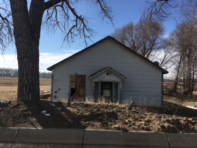
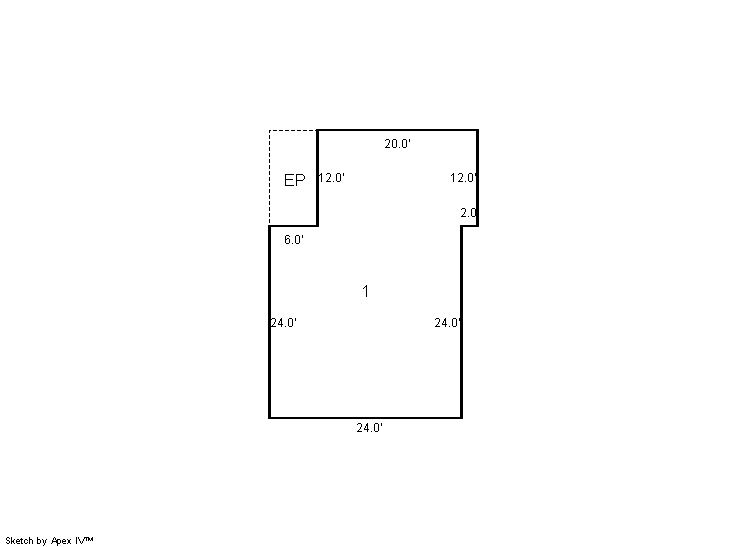
Building 1
| AccountNo | Building ID | Occupancy |
|---|---|---|
| R5388608 | 1 | Single Family Residential on Ag |
| ID | Type | NBHD | Occupancy | % Complete | Bedrooms | Baths |
|---|---|---|---|---|---|---|
| 1 | Residential | 6R3007 | Single Family Residential on Ag | 100 | 2 | 1.00 |
| ID | Exterior | Roof Cover | Interior | HVAC | Perimeter | Units | Unit Type | Make |
|---|---|---|---|---|---|---|---|---|
| 1 | Frame Hardboard | Composition Shingle | Drywall | None | 0 | 0 | NA | NA |
| ID | Square Ft | Condo SF | Total Basement SF | Finished Basement SF | Garage SF | Carport SF | Balcony SF | Porch SF |
|---|---|---|---|---|---|---|---|---|
| 1 | 816 | 0 | 0 | 0 | 0 | 0 | 0 | 72 |
| ID | Built As | Square Ft | Year Built | Stories | Length | Width |
|---|---|---|---|---|---|---|
| 1.00 | Ranch 1 Story | 816 | 1910 | 1 | 0 | 0 |
| ID | Detail Type | Description | Units |
|---|---|---|---|
| 1 | Porch | Encl Solid Wall | 72.00 |
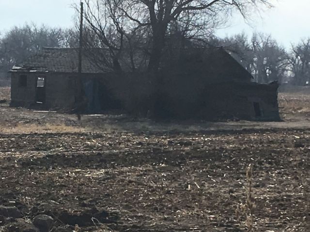
Building 2
| AccountNo | Building ID | Occupancy |
|---|---|---|
| R5388608 | 2 | Utility Building |
| ID | Type | NBHD | Occupancy | % Complete | Bedrooms | Baths |
|---|---|---|---|---|---|---|
| 2 | Out Building | NA | Utility Building | 100 | 0 | 0.00 |
| ID | Exterior | Roof Cover | Interior | HVAC | Perimeter | Units | Unit Type | Make |
|---|---|---|---|---|---|---|---|---|
| 2 | NA | NA | NA | None | 136 | 0 | NA | NA |
| ID | Square Ft | Condo SF | Total Basement SF | Finished Basement SF | Garage SF | Carport SF | Balcony SF | Porch SF |
|---|---|---|---|---|---|---|---|---|
| 2 | 900 | 0 | 0 | 0 | 0 | 0 | 0 | 0 |
| ID | Built As | Square Ft | Year Built | Stories | Length | Width |
|---|---|---|---|---|---|---|
| 2.00 | Utility Building | 900 | 1910 | 1 | 50 | 18 |
No Additional Details for Building 2
| Account | Parcel | Account Type | Tax Year | Buildings | Actual Value | Local Govt Assessed Value | School Assessed Value |
|---|---|---|---|---|---|---|---|
| R5388608 | 105704300030 | Agricultural | 2026 | 2 | 11,415 | 2,870 | 2,880 |
| Type | Code | Description | Actual Value | Local Govt Assessed Value | School Assessed Value | Acres | Land SqFt |
|---|---|---|---|---|---|---|---|
| Improvement | 4277 | FARM/RANCH RESIDENCE-IMPS | 1,000 | 60 | 70 | 0.000 | 0 |
| Improvement | 4279 | FARM RANCH SUPPORT BLDGS | 1,000 | 270 | 270 | 0.000 | 0 |
| Land | 4117 | FLOOD IRRIGATED LAND-AGRICULTURAL | 9,415 | 2,540 | 2,540 | 11.518 | 501,724 |
| Totals | - | - | 11,415 | 2,870 | 2,880 | 11.518 | 501,724 |
Comparable sales for your Residential or Commercial property may be found using our SALES SEARCH TOOL
Values are updated annually on May 1st for Real Property and June 15th for Personal Property and Oil and Gas.
| Account | Parcel | Account Type | Tax Year | Buildings | Actual Value | Local Govt Assessed Value | School Assessed Value |
|---|---|---|---|---|---|---|---|
| R5388608 | 105704300030 | Agricultural | 2026 | 2 | 11,415 | 2,870 | 2,880 |
| Tax Area | District ID | District Name | Local Govt Mill Levy |
School Mill Levy |
Estimated Taxes |
|---|---|---|---|---|---|
| 5744 | 0700 | AIMS JUNIOR COLLEGE | 6.313 | 0.000 | $18.12 |
| 5744 | 0302 | CENTRAL COLORADO WATER (CCW) | 0.980 | 0.000 | $2.81 |
| 5744 | 0309 | CENTRAL COLORADO WATER SUBDISTRICT (CCS) | 1.462 | 0.000 | $4.20 |
| 5744 | 0510 | FRONT RANGE FIRE RESCUE FIRE PROTECTION DISTRICT | 11.483 | 0.000 | $32.96 |
| 5744 | 1050 | HIGH PLAINS LIBRARY | 3.044 | 0.000 | $8.74 |
| 5744 | 0306 | LITTLE THOMPSON WATER (LTW) | 0.000 | 0.000 | $0.00 |
| 5744 | 0301 | NORTHERN COLORADO WATER (NCW) | 1.000 | 0.000 | $2.87 |
| 5744 | 0205 | SCHOOL DIST RE5J-JOHNSTOWN | 0.000 | 36.271 | $104.46 |
| 5744 | 0901 | THOMPSON RIVER REC | 3.594 | 0.000 | $10.31 |
| 5744 | 0100 | WELD COUNTY | 15.956 | 0.000 | $45.79 |
| 5744 | 1200 | WEST GREELEY CONSERVATION | 0.414 | 0.000 | $1.19 |
| Total | - | - | 44.246 | 36.271 | $231.45 |
The estimate of tax is based on the prior year mill levy and the 2025 projected assessment rates. Mill levies and tax estimates will be updated yearly on December 22nd for the current year. Additional information can be found at https://assessor.weld.gov