Account: R5394886
April 1, 2026
| Account | Parcel | Account Type | Tax Year | Buildings | Actual Value | Local Govt Assessed Value | School Assessed Value |
|---|---|---|---|---|---|---|---|
| R5394886 | 131115000020 | Agricultural | 2026 | 1 | 32,161 | 2,040 | 2,300 |
| Legal |
|---|
| 20343-B PT S2NE4 15-2-67 BEG E4 COR S89D41'W 242' N22D55'W 451.5' N26D18'E 799.55' N79D50'E 70' S0D14'W 1146.37' M/L TO BEG |
| Subdivision | Block | Lot | Land Economic Area |
|---|---|---|---|
| CENTRAL ECON 4 RURAL |
| Property Address | Property City | Section | Township | Range |
|---|---|---|---|---|
| 9982 COUNTY ROAD 22 | WELD | 15 | 02 | 67 |
| Account | Parcel | Account Type | Tax Year | Buildings | Actual Value | Local Govt Assessed Value | School Assessed Value |
|---|---|---|---|---|---|---|---|
| R5394886 | 131115000020 | Agricultural | 2026 | 1 | 32,161 | 2,040 | 2,300 |
| Account | Owner Name | Address |
|---|---|---|
| R5394886 | MOUNTRAKIS GEORGIA MARIE | 10301 COUNTY ROAD 20 FORT LUPTON, CO 806218943 |
| Account | Parcel | Account Type | Tax Year | Buildings | Actual Value | Local Govt Assessed Value | School Assessed Value |
|---|---|---|---|---|---|---|---|
| R5394886 | 131115000020 | Agricultural | 2026 | 1 | 32,161 | 2,040 | 2,300 |
| Reception | Rec Date | Type | Grantor | Grantee | Doc Fee | Sale Date | Sale Price |
|---|---|---|---|---|---|---|---|
| 05-21-1986 | USR | USE BY SPECIAL REVIEW | USR-710 KENNEL 200 DOGS | 0.00 | NA | 0 | |
| 02099177 | 05-11-1987 | TRD | 0.00 | 05-08-1987 | 0 | ||
| 02427592 | 02-23-1995 | QCN | 0.00 | 02-20-1995 | 0 | ||
| 2243538 | 03-11-1991 | WD | FRANK ROBERT V | WOKERSIN TED & DARLENE | 0.25 | 03-11-1991 | 2,500 |
| 2899692 | 11-13-2001 | WD | WOKERSIN TED & DARLENE & | ONEILL GEORGIA & WILLIAM | 5.00 | 10-31-2001 | 50,000 |
| 3708895 | 08-02-2010 | SURV | SURVEY | SURVEY | 0.00 | 08-02-2010 | 0 |
| 4467899 | 02-19-2019 | WD | ONEILL WILLIAM | MOUNTRAKIS GEORGIA MARIE | 5.50 | 02-11-2019 | 55,000 |
*If the hyperlink for the reception number does not work, try a manual search in the Clerk and Recorder records. Use the Grantor or Grantee in your search.
| Account | Parcel | Account Type | Tax Year | Buildings | Actual Value | Local Govt Assessed Value | School Assessed Value |
|---|---|---|---|---|---|---|---|
| R5394886 | 131115000020 | Agricultural | 2026 | 1 | 32,161 | 2,040 | 2,300 |
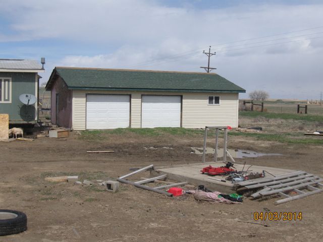
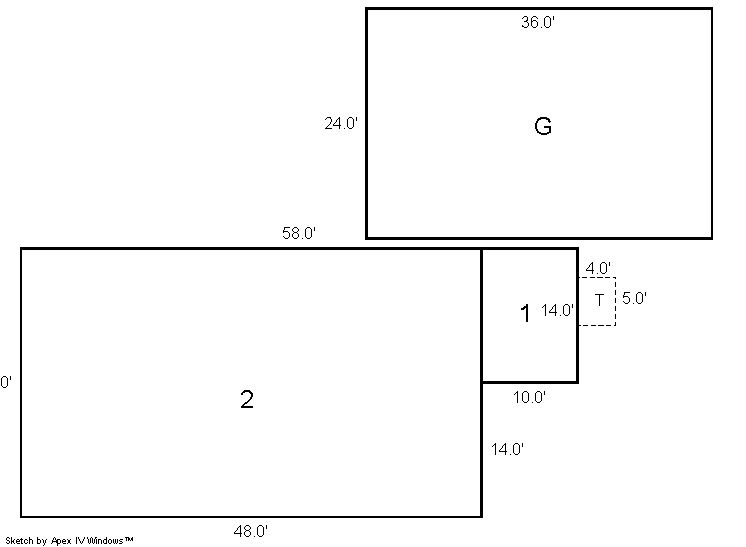
Building 2
| AccountNo | Building ID | Occupancy |
|---|---|---|
| R5394886 | 2 | Detached Garage |
| ID | Type | NBHD | Occupancy | % Complete | Bedrooms | Baths |
|---|---|---|---|---|---|---|
| 2 | Out Building | 4801 | Detached Garage | 100 | 0 | 0.00 |
| ID | Exterior | Roof Cover | Interior | HVAC | Perimeter | Units | Unit Type | Make |
|---|---|---|---|---|---|---|---|---|
| 2 | Frame Vinyl | NA | NA | None | NA | 0 | NA | NA |
| ID | Square Ft | Condo SF | Total Basement SF | Finished Basement SF | Garage SF | Carport SF | Balcony SF | Porch SF |
|---|---|---|---|---|---|---|---|---|
| 2 | 864 | 0 | 0 | 0 | 0 | 0 | 0 | 0 |
| ID | Built As | Square Ft | Year Built | Stories | Length | Width |
|---|---|---|---|---|---|---|
| 2.00 | Detached Garage | 864 | 2002 | 1 | 36 | 24 |
No Additional Details for Building 2
| Account | Parcel | Account Type | Tax Year | Buildings | Actual Value | Local Govt Assessed Value | School Assessed Value |
|---|---|---|---|---|---|---|---|
| R5394886 | 131115000020 | Agricultural | 2026 | 1 | 32,161 | 2,040 | 2,300 |
| Type | Code | Description | Actual Value | Local Govt Assessed Value | School Assessed Value | Acres | Land SqFt |
|---|---|---|---|---|---|---|---|
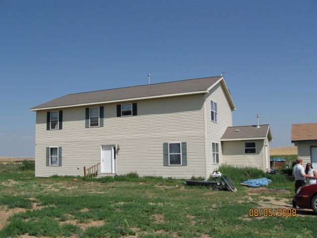
| Improvement | 4277 | FARM/RANCH RESIDENCE-IMPS | 32,028 | 2,000 | 2,260 | 0.000 | 0 |
| Land | 4147 | GRAZING LAND-AGRICULTURAL | 133 | 40 | 40 | 7.190 | 313,196 |
| Totals | - | - | 32,161 | 2,040 | 2,300 | 7.190 | 313,196 |
Comparable sales for your Residential or Commercial property may be found using our SALES SEARCH TOOL
Values are updated annually on May 1st for Real Property and June 15th for Personal Property and Oil and Gas.
| Account | Parcel | Account Type | Tax Year | Buildings | Actual Value | Local Govt Assessed Value | School Assessed Value |
|---|---|---|---|---|---|---|---|
| R5394886 | 131115000020 | Agricultural | 2026 | 1 | 32,161 | 2,040 | 2,300 |
| Tax Area | District ID | District Name | Local Govt Mill Levy |
School Mill Levy |
Estimated Taxes |
|---|---|---|---|---|---|
| 2279 | 0700 | AIMS JUNIOR COLLEGE | 6.313 | 0.000 | $12.88 |
| 2279 | 0506 | FORT LUPTON FIRE | 9.357 | 0.000 | $19.09 |
| 2279 | 1050 | HIGH PLAINS LIBRARY | 3.044 | 0.000 | $6.21 |
| 2279 | 1202 | LONGMONT CONSERVATION | 0.000 | 0.000 | $0.00 |
| 2279 | 0208 | SCHOOL DIST RE8-FORT LUPTON AND DACONO | 0.000 | 18.198 | $41.86 |
| 2279 | 0100 | WELD COUNTY | 15.956 | 0.000 | $32.55 |
| Total | - | - | 34.67 | 18.198 | $112.58 |
The estimate of tax is based on the prior year mill levy and the 2025 projected assessment rates. Mill levies and tax estimates will be updated yearly on December 22nd for the current year. Additional information can be found at https://assessor.weld.gov