Account: R5623486
April 1, 2026
| Account | Parcel | Account Type | Tax Year | Buildings | Actual Value | Local Govt Assessed Value | School Assessed Value |
|---|---|---|---|---|---|---|---|
| R5623486 | 131316000083 | Agricultural | 2026 | 1 | 388,944 | 24,360 | 27,460 |
| Legal |
|---|
| 25153-A N4.5A OF SE4NE4 16 2 68 & PT SE4NE4 BEG N0D20'E 1190.82' FROM E4 COR S89D45'W 743' S0D05'E 40' THENCE N89D45'E 742.71' N0D20'E 40' TO BEG |
| Subdivision | Block | Lot | Land Economic Area |
|---|---|---|---|
| FREDERICK RURAL |
| Property Address | Property City | Section | Township | Range |
|---|---|---|---|---|
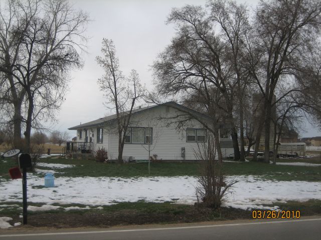
| 9735 COUNTY ROAD 7 | WELD | 16 | 02 | 68 |
| Account | Parcel | Account Type | Tax Year | Buildings | Actual Value | Local Govt Assessed Value | School Assessed Value |
|---|---|---|---|---|---|---|---|
| R5623486 | 131316000083 | Agricultural | 2026 | 1 | 388,944 | 24,360 | 27,460 |
| Account | Owner Name | Address |
|---|---|---|
| R5623486 | REUTH MARY JO (HEIRS OF) | 9735 COUNTY ROAD 7 LONGMONT, CO 805046728 |
| Account | Parcel | Account Type | Tax Year | Buildings | Actual Value | Local Govt Assessed Value | School Assessed Value |
|---|---|---|---|---|---|---|---|
| R5623486 | 131316000083 | Agricultural | 2026 | 1 | 388,944 | 24,360 | 27,460 |
| Reception | Rec Date | Type | Grantor | Grantee | Doc Fee | Sale Date | Sale Price |
|---|---|---|---|---|---|---|---|
| 01629063 | 01-25-1974 | WDN | BLANK PAUL C; BLANK RUTH E | BURRETT WARD; BURRETT MABEL O | 0.00 | 01-24-1974 | 0 |
| 02147550 | 07-11-1988 | DTHC | BURRETT MABEL O | BURRETT WARD | 0.00 | 06-27-1988 | 0 |
| 2604151 | 04-03-1998 | QCN | PARMLEY LEE | REUTH MARY JO | 0.00 | 03-12-1998 | 0 |
| 2624396 | 07-07-1998 | PRDN | BURRETT WARD | REUTH CARL W; REUTH MARY JO | 0.00 | 07-06-1998 | 0 |
| 3236053 | 11-16-2004 | DTHC | REUTH CARL W | REUTH MARY JO | 0.00 | 09-27-2004 | 0 |
| 5076951 | 01-12-2026 | DTHC | REUTH MARY JO | REUTH MARY JO (HEIRS OF) | 0.00 | 06-14-2025 | 0 |
*If the hyperlink for the reception number does not work, try a manual search in the Clerk and Recorder records. Use the Grantor or Grantee in your search.
| Account | Parcel | Account Type | Tax Year | Buildings | Actual Value | Local Govt Assessed Value | School Assessed Value |
|---|---|---|---|---|---|---|---|
| R5623486 | 131316000083 | Agricultural | 2026 | 1 | 388,944 | 24,360 | 27,460 |
Building 1
| AccountNo | Building ID | Occupancy |
|---|---|---|
| R5623486 | 1 | Single Family Residential on Ag |
| ID | Type | NBHD | Occupancy | % Complete | Bedrooms | Baths |
|---|---|---|---|---|---|---|
| 1 | Residential | 3R2021 | Single Family Residential on Ag | 100 | 3 | 1.00 |
| ID | Exterior | Roof Cover | Interior | HVAC | Perimeter | Units | Unit Type | Make |
|---|---|---|---|---|---|---|---|---|
| 1 | Frame Vinyl | Composition Shingle | Drywall | Forced Air | 0 | 0 | NA | NA |
| ID | Square Ft | Condo SF | Total Basement SF | Finished Basement SF | Garage SF | Carport SF | Balcony SF | Porch SF |
|---|---|---|---|---|---|---|---|---|
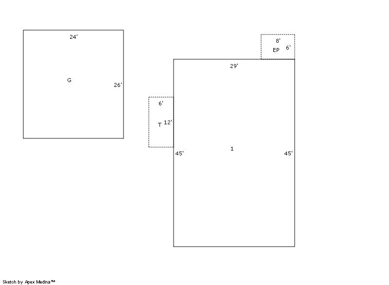
| 1 | 1,305 | 0 | 0 | 0 | 624 | 0 | 0 | 48 |
| ID | Built As | Square Ft | Year Built | Stories | Length | Width |
|---|---|---|---|---|---|---|
| 1.00 | Ranch 1 Story | 1,305 | 1969 | 1 | 0 | 0 |
| ID | Detail Type | Description | Units |
|---|---|---|---|
| 1 | Fixture | Full Bath | 1.00 |
| 1 | Garage | Detached | 624.00 |
| 1 | Porch | Encl Solid Wall | 48.00 |
| 1 | Porch | Open Slab | 72.00 |
| Account | Parcel | Account Type | Tax Year | Buildings | Actual Value | Local Govt Assessed Value | School Assessed Value |
|---|---|---|---|---|---|---|---|
| R5623486 | 131316000083 | Agricultural | 2026 | 1 | 388,944 | 24,360 | 27,460 |
| Type | Code | Description | Actual Value | Local Govt Assessed Value | School Assessed Value | Acres | Land SqFt |
|---|---|---|---|---|---|---|---|
| Improvement | 4277 | FARM/RANCH RESIDENCE-IMPS | 388,764 | 24,300 | 27,410 | 0.000 | 0 |
| Land | 4147 | GRAZING LAND-AGRICULTURAL | 179 | 50 | 50 | 5.054 | 220,152 |
| Land | 4167 | WASTE LAND | 1 | 10 | 0 | 0.126 | 5,489 |
| Totals | - | - | 388,944 | 24,360 | 27,460 | 5.180 | 225,641 |
Comparable sales for your Residential or Commercial property may be found using our SALES SEARCH TOOL
Values are updated annually on May 1st for Real Property and June 15th for Personal Property and Oil and Gas.
| Account | Parcel | Account Type | Tax Year | Buildings | Actual Value | Local Govt Assessed Value | School Assessed Value |
|---|---|---|---|---|---|---|---|
| R5623486 | 131316000083 | Agricultural | 2026 | 1 | 388,944 | 24,360 | 27,460 |
| Tax Area | District ID | District Name | Local Govt Mill Levy |
School Mill Levy |
Estimated Taxes |
|---|---|---|---|---|---|
| 2306 | 1050 | HIGH PLAINS LIBRARY | 3.044 | 0.000 | $74.15 |
| 2306 | 0311 | LEFT HAND WATER | 0.000 | 0.000 | $0.00 |
| 2306 | 1202 | LONGMONT CONSERVATION | 0.000 | 0.000 | $0.00 |
| 2306 | 0512 | MOUNTAIN VIEW FIRE PROTECTION DISTRICT | 16.342 | 0.000 | $398.09 |
| 2306 | 0301 | NORTHERN COLORADO WATER (NCW) | 1.000 | 0.000 | $24.36 |
| 2306 | 0213 | SCHOOL DIST RE1J-LONGMONT | 0.000 | 57.717 | $1,584.91 |
| 2306 | 0100 | WELD COUNTY | 15.956 | 0.000 | $388.69 |
| Total | - | - | 36.342 | 57.717 | $2,470.20 |
The estimate of tax is based on the prior year mill levy and the 2025 projected assessment rates. Mill levies and tax estimates will be updated yearly on December 22nd for the current year. Additional information can be found at https://assessor.weld.gov