Account: R5667486
April 1, 2026
| Account | Parcel | Account Type | Tax Year | Buildings | Actual Value | Local Govt Assessed Value | School Assessed Value |
|---|---|---|---|---|---|---|---|
| R5667486 | 131334302002 | Residential | 2026 | 2 | 494,011 | 30,880 | 34,830 |
| Legal |
|---|
| 25293-C PT L6 PURITAN SUB OF SW4 34 2 68 BEG 20'S OF NE COR L6 S70' W320' N70' E320' TO BEG (.5142A) |
| Subdivision | Block | Lot | Land Economic Area |
|---|---|---|---|
| PURITAN SUB | 6 | PURITAN |
| Property Address | Property City | Section | Township | Range |
|---|---|---|---|---|
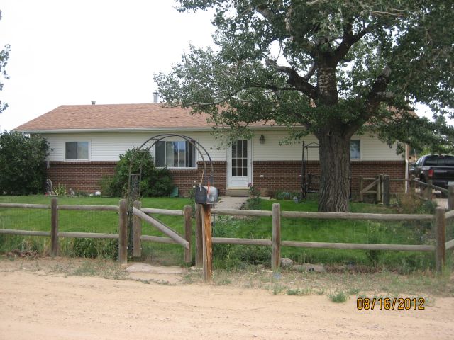
| 3331 HIGHWAY 52 | WELD | 34 | 02 | 68 |
| Account | Parcel | Account Type | Tax Year | Buildings | Actual Value | Local Govt Assessed Value | School Assessed Value |
|---|---|---|---|---|---|---|---|
| R5667486 | 131334302002 | Residential | 2026 | 2 | 494,011 | 30,880 | 34,830 |
| Account | Owner Name | Address |
|---|---|---|
| R5667486 | AKIA ERIK | 3331 STATE HIGHWAY 52 ERIE, CO 805169405 |
| R5667486 | AKIA LEEWITT |
| Account | Parcel | Account Type | Tax Year | Buildings | Actual Value | Local Govt Assessed Value | School Assessed Value |
|---|---|---|---|---|---|---|---|
| R5667486 | 131334302002 | Residential | 2026 | 2 | 494,011 | 30,880 | 34,830 |
| Reception | Rec Date | Type | Grantor | Grantee | Doc Fee | Sale Date | Sale Price |
|---|---|---|---|---|---|---|---|
| 02003487 | 03-27-1985 | QCN | 0.00 | 01-01-1900 | 0 | ||
| 02309522 | 11-03-1992 | QCN | 0.00 | 10-02-1992 | 0 | ||
| 1009475 | NA | SUB | SUBDIVISION | PURITAN | 0.00 | NA | 0 |
| 2309523 | 11-03-1992 | WD | LONTINE LEROY & MARY LANE | OSTRANDER FRANK A | 9.50 | 10-30-1992 | 95,000 |
| 3989422 | 01-10-2014 | QCN | OSTRANDER FRANK A | OSTRANDER FRANK A | 0.00 | 02-07-2013 | 0 |
| 4238296 | 09-21-2016 | WD | OSTRANDER FRANK A; OSTRANDER GERALYN S | CURRIER SCOTT W | 27.80 | 09-15-2016 | 278,000 |
| 4852771 | 09-01-2022 | SWD | CURRIER SCOTT W | AKIA ERIK; AKIA LEEWITT | 48.50 | 08-30-2022 | 485,000 |
| 4866912 | 11-14-2022 | SURV | SURVEY | SURVEY | 0.00 | 10-18-2022 | 0 |
*If the hyperlink for the reception number does not work, try a manual search in the Clerk and Recorder records. Use the Grantor or Grantee in your search.
| Account | Parcel | Account Type | Tax Year | Buildings | Actual Value | Local Govt Assessed Value | School Assessed Value |
|---|---|---|---|---|---|---|---|
| R5667486 | 131334302002 | Residential | 2026 | 2 | 494,011 | 30,880 | 34,830 |
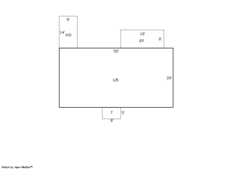
Building 1
| AccountNo | Building ID | Occupancy |
|---|---|---|
| R5667486 | 1 | Single Family Residential |
| ID | Type | NBHD | Occupancy | % Complete | Bedrooms | Baths |
|---|---|---|---|---|---|---|
| 1 | Residential | 3R2021 | Single Family Residential | 100 | 3 | 2.00 |
| ID | Exterior | Roof Cover | Interior | HVAC | Perimeter | Units | Unit Type | Make |
|---|---|---|---|---|---|---|---|---|
| 1 | Frame Masonry Veneer | Composition Shingle | Drywall | Forced Air | 0 | 0 | NA | NA |
| ID | Square Ft | Condo SF | Total Basement SF | Finished Basement SF | Garage SF | Carport SF | Balcony SF | Porch SF |
|---|---|---|---|---|---|---|---|---|
| 1 | 1,300 | 0 | 1,300 | 1,300 | 0 | 0 | 0 | 112 |
| ID | Built As | Square Ft | Year Built | Stories | Length | Width |
|---|---|---|---|---|---|---|
| 1.00 | Ranch 1 Story | 1,300 | 1981 | 1 | 0 | 0 |
| ID | Detail Type | Description | Units |
|---|---|---|---|
| 1 | Add On | Flue Only | 1.00 |
| 1 | Basement | Finished | 1300.00 |
| 1 | Basement | Total Basement SF | 1300.00 |
| 1 | Fixture | Full Bath | 2.00 |
| 1 | Porch | Encl Solid Wall | 152.00 |
| 1 | Porch | Open Slab | 40.00 |
| 1 | Porch | Wood Deck | 112.00 |
Building 2
| AccountNo | Building ID | Occupancy |
|---|---|---|
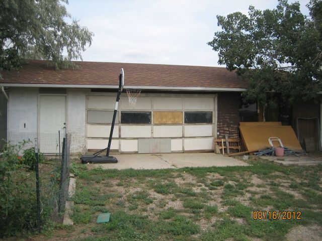
| R5667486 | 2 | Utility Building |
| ID | Type | NBHD | Occupancy | % Complete | Bedrooms | Baths |
|---|---|---|---|---|---|---|
| 2 | Out Building | NA | Utility Building | 100 | 0 | 0.00 |
| ID | Exterior | Roof Cover | Interior | HVAC | Perimeter | Units | Unit Type | Make |
|---|---|---|---|---|---|---|---|---|
| 2 | NA | NA | NA | None | 128 | 0 | NA | NA |
| ID | Square Ft | Condo SF | Total Basement SF | Finished Basement SF | Garage SF | Carport SF | Balcony SF | Porch SF |
|---|---|---|---|---|---|---|---|---|
| 2 | 960 | 0 | 0 | 0 | 0 | 0 | 0 | 0 |
| ID | Built As | Square Ft | Year Built | Stories | Length | Width |
|---|---|---|---|---|---|---|
| 2.00 | Utility Building | 960 | 1986 | 1 | 40 | 24 |
| ID | Detail Type | Description | Units |
|---|---|---|---|
| 2 | Add On | OB Open Shelter Lean To Wood | 480.00 |
| Account | Parcel | Account Type | Tax Year | Buildings | Actual Value | Local Govt Assessed Value | School Assessed Value |
|---|---|---|---|---|---|---|---|
| R5667486 | 131334302002 | Residential | 2026 | 2 | 494,011 | 30,880 | 34,830 |
| Type | Code | Description | Actual Value | Local Govt Assessed Value | School Assessed Value | Acres | Land SqFt |
|---|---|---|---|---|---|---|---|
| Improvement | 1212 | SINGLE FAMILY RESIDENTIAL IMPROVEMENTS | 314,404 | 19,650 | 22,170 | 0.000 | 0 |
| Land | 1112 | SINGLE FAMILY RESIDENTIAL-LAND | 179,607 | 11,230 | 12,660 | 0.520 | 22,651 |
| Totals | - | - | 494,011 | 30,880 | 34,830 | 0.520 | 22,651 |
Comparable sales for your Residential or Commercial property may be found using our SALES SEARCH TOOL
Values are updated annually on May 1st for Real Property and June 15th for Personal Property and Oil and Gas.
| Account | Parcel | Account Type | Tax Year | Buildings | Actual Value | Local Govt Assessed Value | School Assessed Value |
|---|---|---|---|---|---|---|---|
| R5667486 | 131334302002 | Residential | 2026 | 2 | 494,011 | 30,880 | 34,830 |
| Tax Area | District ID | District Name | Local Govt Mill Levy |
School Mill Levy |
Estimated Taxes |
|---|---|---|---|---|---|
| 2300 | 0507 | FREDERICK-FIRESTONE FIRE | 15.559 | 0.000 | $480.46 |
| 2300 | 1050 | HIGH PLAINS LIBRARY | 3.044 | 0.000 | $94.00 |
| 2300 | 0311 | LEFT HAND WATER | 0.000 | 0.000 | $0.00 |
| 2300 | 1202 | LONGMONT CONSERVATION | 0.000 | 0.000 | $0.00 |
| 2300 | 0301 | NORTHERN COLORADO WATER (NCW) | 1.000 | 0.000 | $30.88 |
| 2300 | 0213 | SCHOOL DIST RE1J-LONGMONT | 0.000 | 57.717 | $2,010.28 |
| 2300 | 0100 | WELD COUNTY | 15.956 | 0.000 | $492.72 |
| Total | - | - | 35.559 | 57.717 | $3,108.35 |
The estimate of tax is based on the prior year mill levy and the 2025 projected assessment rates. Mill levies and tax estimates will be updated yearly on December 22nd for the current year. Additional information can be found at https://assessor.weld.gov