Account: R6194286
April 5, 2026
| Account | Parcel | Account Type | Tax Year | Buildings | Actual Value | Local Govt Assessed Value | School Assessed Value |
|---|---|---|---|---|---|---|---|
| R6194286 | 147107102010 | Residential | 2026 | 1 | 349,346 | 21,840 | 24,630 |
| Legal |
|---|
| PA2-15 L15 PEACEFUL ACRES |
| Subdivision | Block | Lot | Land Economic Area |
|---|---|---|---|
| PEACEFUL ACRES | 15 | FORT LUPTON SOUTH |
| Property Address | Property City | Section | Township | Range |
|---|---|---|---|---|
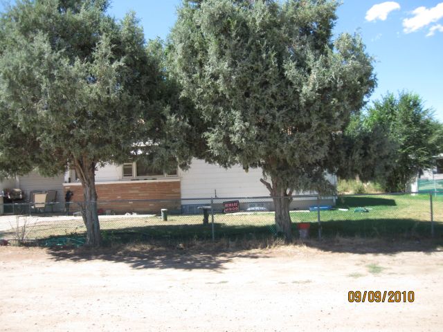
| 635 S PARK AVE | WELD | 07 | 01 | 66 |
| Account | Parcel | Account Type | Tax Year | Buildings | Actual Value | Local Govt Assessed Value | School Assessed Value |
|---|---|---|---|---|---|---|---|
| R6194286 | 147107102010 | Residential | 2026 | 1 | 349,346 | 21,840 | 24,630 |
| Account | Owner Name | Address |
|---|---|---|
| R6194286 | DECHANT DUSTIN R | 635 S PARK AVE FORT LUPTON, CO 806211230 |
| Account | Parcel | Account Type | Tax Year | Buildings | Actual Value | Local Govt Assessed Value | School Assessed Value |
|---|---|---|---|---|---|---|---|
| R6194286 | 147107102010 | Residential | 2026 | 1 | 349,346 | 21,840 | 24,630 |
| Reception | Rec Date | Type | Grantor | Grantee | Doc Fee | Sale Date | Sale Price |
|---|---|---|---|---|---|---|---|
| 12-16-1976 | COZ | WELD COUNTY ZONING | CASE: Z-27* ZONING R-2 | 0.00 | NA | 0 | |
| 01775018 | 12-07-1978 | WDN | 0.00 | 01-01-1900 | 0 | ||
| 1207210 | NA | SUB | SUBDIVISION | PEACEFUL ACRES | 0.00 | NA | 0 |
| 2868121 | 07-24-2001 | WD | LINDSEY FREDERICK DANIEL & MARIE E | BAYLON RAFAEL | 14.60 | 07-18-2001 | 146,000 |
| 3285850 | 05-13-2005 | WD | BAYLON RAFAEL | LARSEN STACIE | 17.00 | 05-11-2005 | 170,000 |
| 3579399 | 09-22-2008 | QCN | LARSEN STACIE | 635 SOUTH PARK LARSEN LAND TRUST | 0.00 | 08-21-2008 | 0 |
| 3665094 | 12-15-2009 | PTD | LARSEN STACIE | BANK NEW YORK MELLON | 0.00 | 12-14-2009 | 0 |
| 3688638 | 04-22-2010 | SWD | BANK NEW YORK | DECHANT DUSTIN R | 10.50 | 04-05-2010 | 105,000 |
*If the hyperlink for the reception number does not work, try a manual search in the Clerk and Recorder records. Use the Grantor or Grantee in your search.
| Account | Parcel | Account Type | Tax Year | Buildings | Actual Value | Local Govt Assessed Value | School Assessed Value |
|---|---|---|---|---|---|---|---|
| R6194286 | 147107102010 | Residential | 2026 | 1 | 349,346 | 21,840 | 24,630 |
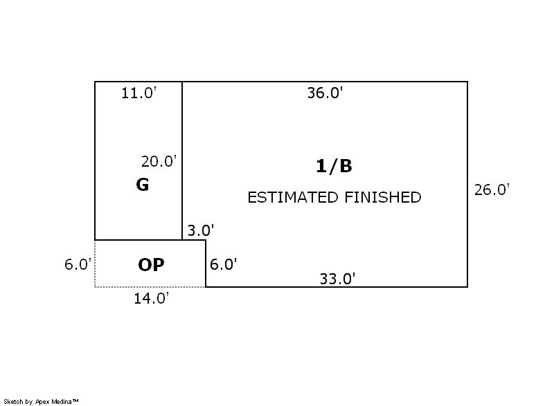
Building 1
| AccountNo | Building ID | Occupancy |
|---|---|---|
| R6194286 | 1 | Single Family Residential |
| ID | Type | NBHD | Occupancy | % Complete | Bedrooms | Baths |
|---|---|---|---|---|---|---|
| 1 | Residential | 4F1007 | Single Family Residential | 100 | 3 | 1.00 |
| ID | Exterior | Roof Cover | Interior | HVAC | Perimeter | Units | Unit Type | Make |
|---|---|---|---|---|---|---|---|---|
| 1 | Frame Hardboard | Composition Shingle | Drywall | Forced Air | 0 | 0 | NA | NA |
| ID | Square Ft | Condo SF | Total Basement SF | Finished Basement SF | Garage SF | Carport SF | Balcony SF | Porch SF |
|---|---|---|---|---|---|---|---|---|
| 1 | 918 | 0 | 918 | 918 | 220 | 0 | 0 | 84 |
| ID | Built As | Square Ft | Year Built | Stories | Length | Width |
|---|---|---|---|---|---|---|
| 1.00 | Ranch 1 Story | 918 | 1960 | 1 | 0 | 0 |
| ID | Detail Type | Description | Units |
|---|---|---|---|
| 1 | Basement | Finished | 918.00 |
| 1 | Basement | Total Basement SF | 918.00 |
| 1 | Fixture | Full Bath | 1.00 |
| 1 | Garage | Attached | 220.00 |
| 1 | Porch | Slab Roof Ceil | 84.00 |
| Account | Parcel | Account Type | Tax Year | Buildings | Actual Value | Local Govt Assessed Value | School Assessed Value |
|---|---|---|---|---|---|---|---|
| R6194286 | 147107102010 | Residential | 2026 | 1 | 349,346 | 21,840 | 24,630 |
| Type | Code | Description | Actual Value | Local Govt Assessed Value | School Assessed Value | Acres | Land SqFt |
|---|---|---|---|---|---|---|---|
| Improvement | 1212 | SINGLE FAMILY RESIDENTIAL IMPROVEMENTS | 259,346 | 16,210 | 18,280 | 0.000 | 0 |
| Land | 1112 | SINGLE FAMILY RESIDENTIAL-LAND | 90,000 | 5,630 | 6,350 | 0.298 | 13,000 |
| Totals | - | - | 349,346 | 21,840 | 24,630 | 0.298 | 13,000 |
Comparable sales for your Residential or Commercial property may be found using our SALES SEARCH TOOL
Values are updated annually on May 1st for Real Property and June 15th for Personal Property and Oil and Gas.
| Account | Parcel | Account Type | Tax Year | Buildings | Actual Value | Local Govt Assessed Value | School Assessed Value |
|---|---|---|---|---|---|---|---|
| R6194286 | 147107102010 | Residential | 2026 | 1 | 349,346 | 21,840 | 24,630 |
| Tax Area | District ID | District Name | Local Govt Mill Levy |
School Mill Levy |
Estimated Taxes |
|---|---|---|---|---|---|
| 3686 | 0700 | AIMS JUNIOR COLLEGE | 6.313 | 0.000 | $137.88 |
| 3686 | 0302 | CENTRAL COLORADO WATER (CCW) | 0.980 | 0.000 | $21.40 |
| 3686 | 0309 | CENTRAL COLORADO WATER SUBDISTRICT (CCS) | 1.462 | 0.000 | $31.93 |
| 3686 | 0506 | FORT LUPTON FIRE | 9.357 | 0.000 | $204.36 |
| 3686 | 1050 | HIGH PLAINS LIBRARY | 3.044 | 0.000 | $66.48 |
| 3686 | 1201 | PLATTE VALLEY CONSERVATION | 0.000 | 0.000 | $0.00 |
| 3686 | 0208 | SCHOOL DIST RE8-FORT LUPTON AND DACONO | 0.000 | 18.198 | $448.22 |
| 3686 | 0100 | WELD COUNTY | 15.956 | 0.000 | $348.48 |
| Total | - | - | 37.112 | 18.198 | $1,258.74 |
The estimate of tax is based on the prior year mill levy and the 2025 projected assessment rates. Mill levies and tax estimates will be updated yearly on December 22nd for the current year. Additional information can be found at https://assessor.weld.gov