Account: R6784898
April 5, 2026
| Account | Parcel | Account Type | Tax Year | Buildings | Actual Value | Local Govt Assessed Value | School Assessed Value |
|---|---|---|---|---|---|---|---|
| R6784898 | 070516300002 | Agricultural | 2026 | 3 | 649,597 | 49,060 | 53,930 |
| Legal |
|---|
| PT SW4 16 7 67 LOT B REC EXEMPT RE-4897 |
| Subdivision | Block | Lot | Land Economic Area |
|---|---|---|---|
| WINDSOR RURAL |
| Property Address | Property City | Section | Township | Range |
|---|---|---|---|---|
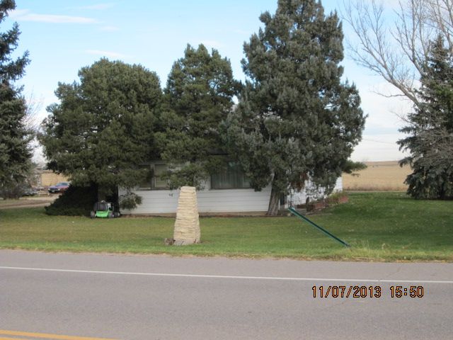
| 39330 HIGHWAY 257 | WELD | 16 | 07 | 67 |
| Account | Parcel | Account Type | Tax Year | Buildings | Actual Value | Local Govt Assessed Value | School Assessed Value |
|---|---|---|---|---|---|---|---|
| R6784898 | 070516300002 | Agricultural | 2026 | 3 | 649,597 | 49,060 | 53,930 |
| Account | Owner Name | Address |
|---|---|---|
| R6784898 | CACTUS HILL RANCH COMPANY | PO BOX 691 WINDSOR, CO 805500691 |
| Account | Parcel | Account Type | Tax Year | Buildings | Actual Value | Local Govt Assessed Value | School Assessed Value |
|---|---|---|---|---|---|---|---|
| R6784898 | 070516300002 | Agricultural | 2026 | 3 | 649,597 | 49,060 | 53,930 |
| Reception | Rec Date | Type | Grantor | Grantee | Doc Fee | Sale Date | Sale Price |
|---|---|---|---|---|---|---|---|
| 3968121 | 10-03-2013 | RE | RECORDED EXEMPTION | RE-4897 | 0.00 | NA | 0 |
| 3968121 | 10-03-2013 | RE | RE 4897 | RE 4897 | 0.00 | 09-24-2013 | 0 |
| 4076256 | 01-16-2015 | SWD | THORNTON CITY OF | CACTUS HILL RANCH COMPANY | 236.00 | 01-22-2015 | 2,360,000 |
*If the hyperlink for the reception number does not work, try a manual search in the Clerk and Recorder records. Use the Grantor or Grantee in your search.
| Account | Parcel | Account Type | Tax Year | Buildings | Actual Value | Local Govt Assessed Value | School Assessed Value |
|---|---|---|---|---|---|---|---|
| R6784898 | 070516300002 | Agricultural | 2026 | 3 | 649,597 | 49,060 | 53,930 |
Building 1
| AccountNo | Building ID | Occupancy |
|---|---|---|
| R6784898 | 1 | Single Family Residential on Ag |
| ID | Type | NBHD | Occupancy | % Complete | Bedrooms | Baths |
|---|---|---|---|---|---|---|
| 1 | Residential | 2R2001 | Single Family Residential on Ag | 100 | 3 | 1.00 |
| ID | Exterior | Roof Cover | Interior | HVAC | Perimeter | Units | Unit Type | Make |
|---|---|---|---|---|---|---|---|---|
| 1 | Frame Hardboard | Composition Shingle | Drywall | Hot Water Baseboard | 164 | 0 | NA | NA |
| ID | Square Ft | Condo SF | Total Basement SF | Finished Basement SF | Garage SF | Carport SF | Balcony SF | Porch SF |
|---|---|---|---|---|---|---|---|---|
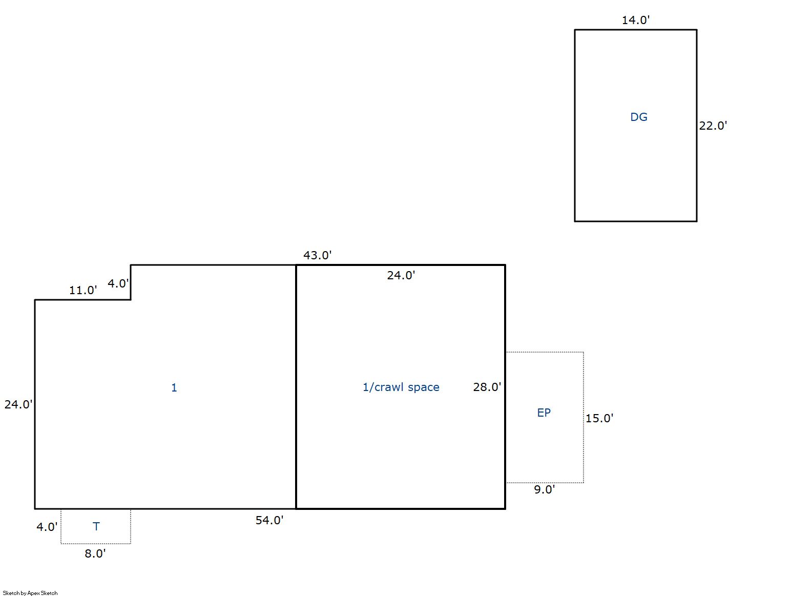
| 1 | 1,468 | 0 | 0 | 0 | 308 | 0 | 0 | 32 |
| ID | Built As | Square Ft | Year Built | Stories | Length | Width |
|---|---|---|---|---|---|---|
| 1.00 | Ranch 1 Story | 1,468 | 1925 | 1 | 0 | 0 |
| ID | Detail Type | Description | Units |
|---|---|---|---|
| 1 | Fixture | Full Bath | 1.00 |
| 1 | Garage | Detached | 308.00 |
| 1 | Porch | Encl Solid Wall | 135.00 |
| 1 | Porch | Open Slab | 32.00 |
Building 2
| AccountNo | Building ID | Occupancy |
|---|---|---|
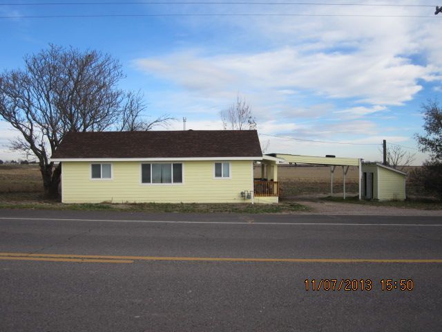
| R6784898 | 2 | Secondary Single Family Res on Ag |
| ID | Type | NBHD | Occupancy | % Complete | Bedrooms | Baths |
|---|---|---|---|---|---|---|
| 2 | Residential | 2R2001 | Secondary Single Family Res on Ag | 100 | 2 | 1.00 |
| ID | Exterior | Roof Cover | Interior | HVAC | Perimeter | Units | Unit Type | Make |
|---|---|---|---|---|---|---|---|---|
| 2 | Frame Hardboard | Composition Shingle | Drywall | Central Air to Air | 120 | 0 | NA | NA |
| ID | Square Ft | Condo SF | Total Basement SF | Finished Basement SF | Garage SF | Carport SF | Balcony SF | Porch SF |
|---|---|---|---|---|---|---|---|---|
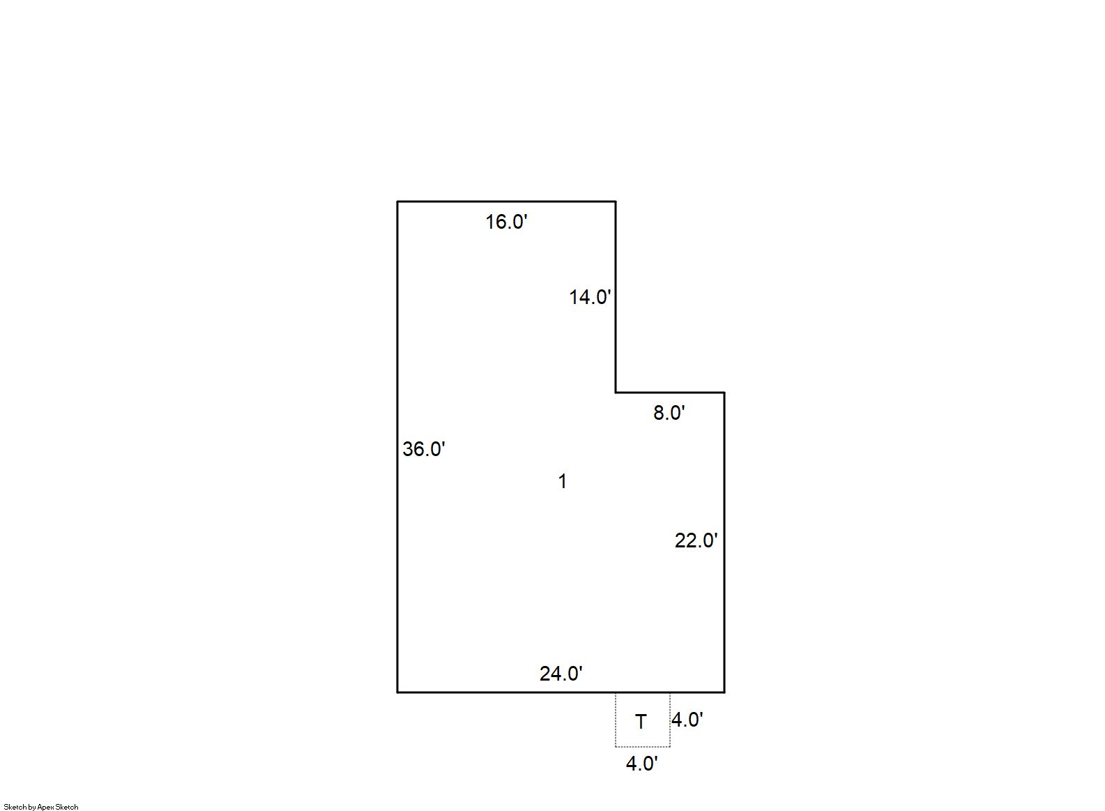
| 2 | 752 | 0 | 0 | 0 | 0 | 0 | 0 | 16 |
| ID | Built As | Square Ft | Year Built | Stories | Length | Width |
|---|---|---|---|---|---|---|
| 2.00 | Ranch 1 Story | 752 | 1925 | 1 | 0 | 0 |
| ID | Detail Type | Description | Units |
|---|---|---|---|
| 2 | Fixture | Full Bath | 1.00 |
| 2 | Porch | Open Slab | 16.00 |
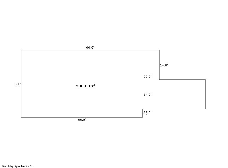
Building 3
| AccountNo | Building ID | Occupancy |
|---|---|---|
| R6784898 | 3 | Utility Building |
| ID | Type | NBHD | Occupancy | % Complete | Bedrooms | Baths |
|---|---|---|---|---|---|---|
| 3 | Out Building | NA | Utility Building | 100 | 0 | 0.00 |
| ID | Exterior | Roof Cover | Interior | HVAC | Perimeter | Units | Unit Type | Make |
|---|---|---|---|---|---|---|---|---|
| 3 | NA | NA | NA | None | 0 | 0 | NA | NA |
| ID | Square Ft | Condo SF | Total Basement SF | Finished Basement SF | Garage SF | Carport SF | Balcony SF | Porch SF |
|---|---|---|---|---|---|---|---|---|
| 3 | 2,388 | 0 | 0 | 0 | 0 | 0 | 0 | 0 |
| ID | Built As | Square Ft | Year Built | Stories | Length | Width |
|---|---|---|---|---|---|---|
| 3.00 | Utility Building | 2,388 | 1920 | 1 | 0 | 0 |
No Additional Details for Building 3
| Account | Parcel | Account Type | Tax Year | Buildings | Actual Value | Local Govt Assessed Value | School Assessed Value |
|---|---|---|---|---|---|---|---|
| R6784898 | 070516300002 | Agricultural | 2026 | 3 | 649,597 | 49,060 | 53,930 |
| Type | Code | Description | Actual Value | Local Govt Assessed Value | School Assessed Value | Acres | Land SqFt |
|---|---|---|---|---|---|---|---|
| Improvement | 4277 | FARM/RANCH RESIDENCE-IMPS | 608,837 | 38,050 | 42,920 | 0.000 | 0 |
| Improvement | 4279 | FARM RANCH SUPPORT BLDGS | 100 | 30 | 30 | 0.000 | 0 |
| Land | 4107 | SPRINKLER IRRIGATED LAND | 39,408 | 10,640 | 10,640 | 85.055 | 3,704,996 |
| Land | 4127 | DRY FARM LAND-AGRICULTURAL | 1,195 | 320 | 320 | 9.054 | 394,392 |
| Land | 4167 | WASTE LAND | 57 | 20 | 20 | 8.631 | 375,966 |
| Totals | - | - | 649,597 | 49,060 | 53,930 | 102.740 | 4,475,354 |
Comparable sales for your Residential or Commercial property may be found using our SALES SEARCH TOOL
Values are updated annually on May 1st for Real Property and June 15th for Personal Property and Oil and Gas.
| Account | Parcel | Account Type | Tax Year | Buildings | Actual Value | Local Govt Assessed Value | School Assessed Value |
|---|---|---|---|---|---|---|---|
| R6784898 | 070516300002 | Agricultural | 2026 | 3 | 649,597 | 49,060 | 53,930 |
| Tax Area | District ID | District Name | Local Govt Mill Levy |
School Mill Levy |
Estimated Taxes |
|---|---|---|---|---|---|
| 2410 | 0700 | AIMS JUNIOR COLLEGE | 6.313 | 0.000 | $309.72 |
| 2410 | 1051 | CLEARVIEW LIBRARY | 3.546 | 0.000 | $173.97 |
| 2410 | 1206 | LARIMER CONSERVATION DISTRICT | 0.000 | 0.000 | $0.00 |
| 2410 | 0304 | NORTH WELD COUNTY WATER (NWC) | 0.000 | 0.000 | $0.00 |
| 2410 | 0301 | NORTHERN COLORADO WATER (NCW) | 1.000 | 0.000 | $49.06 |
| 2410 | 0204 | SCHOOL DIST RE4-WINDSOR | 0.000 | 46.646 | $2,515.62 |
| 2410 | 0100 | WELD COUNTY | 15.956 | 0.000 | $782.80 |
| 2410 | 0521 | WINDSOR-SEVERANCE FIRE | 8.535 | 0.000 | $418.73 |
| Total | - | - | 35.35 | 46.646 | $4,249.89 |
The estimate of tax is based on the prior year mill levy and the 2025 projected assessment rates. Mill levies and tax estimates will be updated yearly on December 22nd for the current year. Additional information can be found at https://assessor.weld.gov