Account: R6829097
April 2, 2026
| Account | Parcel | Account Type | Tax Year | Buildings | Actual Value | Local Govt Assessed Value | School Assessed Value |
|---|---|---|---|---|---|---|---|
| R6829097 | 120723304001 | Commercial | 2026 | 2 | 3,452,355 | 932,140 | 932,140 |
| Legal |
|---|
| L1 NORTH VALLEY DRIVE CONDOS (AKA VALLEY 66 BUSINESS PARK) |
| Subdivision | Block | Lot | Land Economic Area |
|---|---|---|---|
| VALLEY 66 BUSINESS PARK | 1 | MEAD SEKICH, VALLEY 66, LYONS 66 |
| Property Address | Property City | Section | Township | Range |
|---|---|---|---|---|
| 14215 MEAD ST | MEAD | 23 | 03 | 68 |
| Account | Parcel | Account Type | Tax Year | Buildings | Actual Value | Local Govt Assessed Value | School Assessed Value |
|---|---|---|---|---|---|---|---|
| R6829097 | 120723304001 | Commercial | 2026 | 2 | 3,452,355 | 932,140 | 932,140 |
| Account | Owner Name | Address |
|---|---|---|
| R6829097 | 14215 MEAD STREET LLC | 3101 IRIS AVE STE 240 BOULDER, CO 803011495 |
| Account | Parcel | Account Type | Tax Year | Buildings | Actual Value | Local Govt Assessed Value | School Assessed Value |
|---|---|---|---|---|---|---|---|
| R6829097 | 120723304001 | Commercial | 2026 | 2 | 3,452,355 | 932,140 | 932,140 |
| Reception | Rec Date | Type | Grantor | Grantee | Doc Fee | Sale Date | Sale Price |
|---|---|---|---|---|---|---|---|
| 2539911 | NA | SUB | SUBDIVISION | VALLEY 66 BUSINESS PARK PHASE 5 | 0.00 | NA | 0 |
| 2584822 | 12-17-1997 | WD | VALLEY SIXTY-SIX | BDI INVESTMENT LLC | 8.50 | 12-09-1997 | 85,000 |
| 2725728 | 10-08-1999 | WDN | BDI INVESTMENT LLC | WELLSTAR CORPORATION | 0.00 | 09-10-1999 | 0 |
| 4499139 | 06-20-2019 | SWDN | WELLSTAR CORPORATION | MAYER DALE A (90 %); MAYER DALE A IRREVOCABLE FAMILY TRUST (10 %) | 0.00 | 02-05-2019 | 0 |
| 4499235 | 06-20-2019 | SWDN | MAYER DALE A; MAYER DALE A IRREVOCABLE FAMILY TRUST | 14215 MEAD STREET LLC | 0.00 | 02-05-2019 | 0 |
*If the hyperlink for the reception number does not work, try a manual search in the Clerk and Recorder records. Use the Grantor or Grantee in your search.
| Account | Parcel | Account Type | Tax Year | Buildings | Actual Value | Local Govt Assessed Value | School Assessed Value |
|---|---|---|---|---|---|---|---|
| R6829097 | 120723304001 | Commercial | 2026 | 2 | 3,452,355 | 932,140 | 932,140 |
Building 1
| AccountNo | Building ID | Occupancy |
|---|---|---|
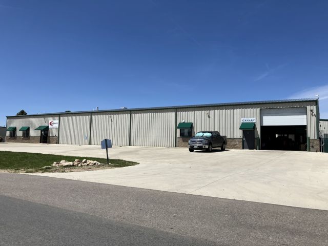
| R6829097 | 1 | Warehouse |
| ID | Type | NBHD | Occupancy | % Complete | Bedrooms | Baths |
|---|---|---|---|---|---|---|
| 1 | Commercial | 3923 | Warehouse | 100 | 0 | 0.00 |
| ID | Exterior | Roof Cover | Interior | HVAC | Perimeter | Units | Unit Type | Make |
|---|---|---|---|---|---|---|---|---|
| 1 | NA | NA | NA | Radiant | 484 | 0 | NA | NA |
| ID | Square Ft | Condo SF | Total Basement SF | Finished Basement SF | Garage SF | Carport SF | Balcony SF | Porch SF |
|---|---|---|---|---|---|---|---|---|
| 1 | 12,525 | 0 | 0 | 0 | 0 | 0 | 0 | 0 |
| ID | Built As | Square Ft | Year Built | Stories | Length | Width |
|---|---|---|---|---|---|---|
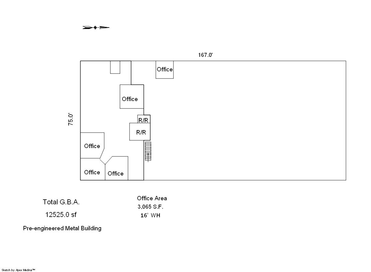
| 1.00 | Office Building | 3,113 | 1998 | 1 | 0 | 0 |
| 1.00 | Storage Warehouse | 9,412 | 1998 | 1 | 0 | 0 |
| ID | Detail Type | Description | Units |
|---|---|---|---|
| 1 | Add On | Chain Link Fence 6Ft. | 900.00 |
| 1 | Add On | Concrete Slab | 960.00 |
| 1 | Add On | Loading Docks Filled Conc Walls & Floor | 884.00 |
Building 2
| AccountNo | Building ID | Occupancy |
|---|---|---|
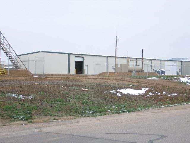
| R6829097 | 2 | Warehouse |
| ID | Type | NBHD | Occupancy | % Complete | Bedrooms | Baths |
|---|---|---|---|---|---|---|
| 2 | Commercial | 3923 | Warehouse | 100 | 0 | 0.00 |
| ID | Exterior | Roof Cover | Interior | HVAC | Perimeter | Units | Unit Type | Make |
|---|---|---|---|---|---|---|---|---|
| 2 | NA | NA | NA | Space Heater | 580 | 0 | NA | NA |
| ID | Square Ft | Condo SF | Total Basement SF | Finished Basement SF | Garage SF | Carport SF | Balcony SF | Porch SF |
|---|---|---|---|---|---|---|---|---|
| 2 | 11,993 | 0 | 0 | 0 | 0 | 0 | 0 | 0 |
| ID | Built As | Square Ft | Year Built | Stories | Length | Width |
|---|---|---|---|---|---|---|
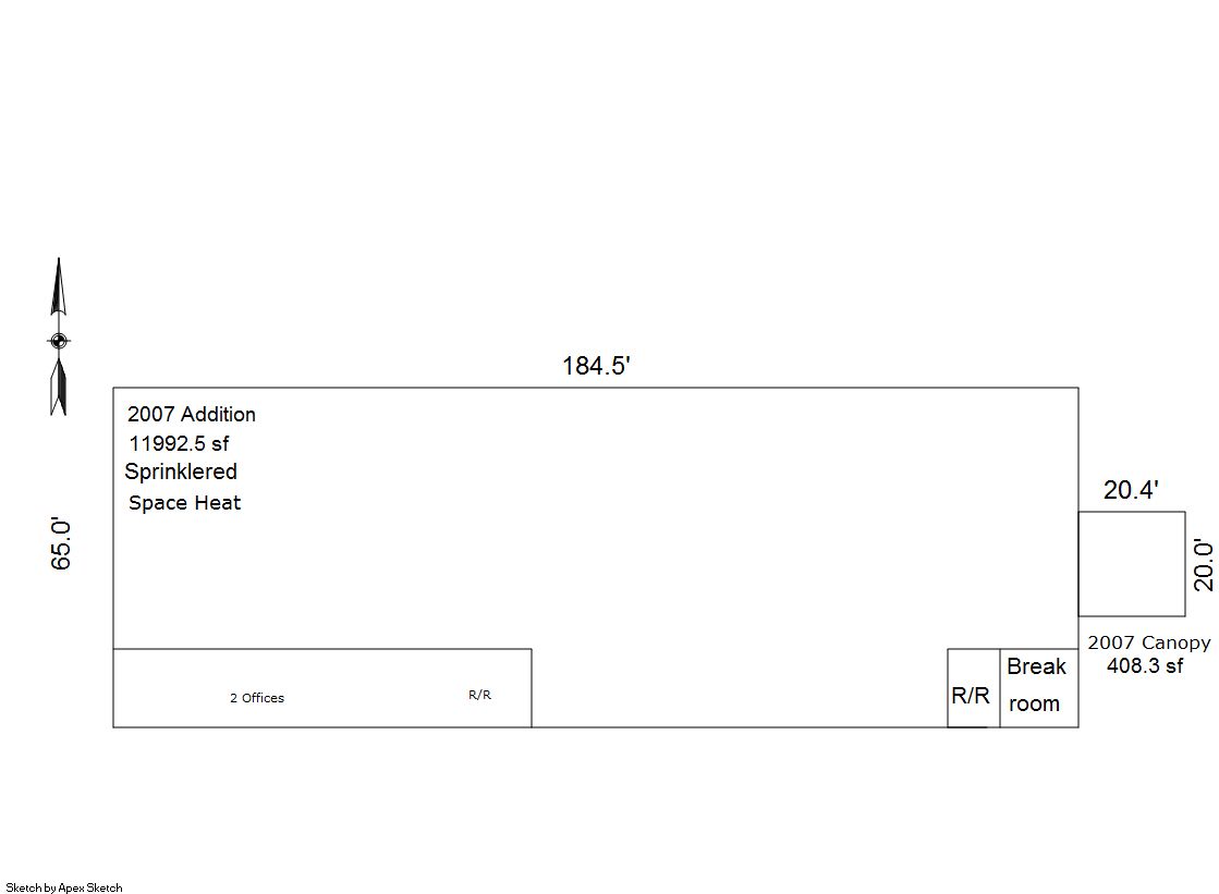
| 2.00 | Storage Warehouse | 11,993 | 2007 | 1 | 0 | 0 |
| ID | Detail Type | Description | Units |
|---|---|---|---|
| 2 | Add On | Com Canopies Steel Average | 408.00 |
| 2 | Add On | Com Office Finish Average | 600.00 |
| Account | Parcel | Account Type | Tax Year | Buildings | Actual Value | Local Govt Assessed Value | School Assessed Value |
|---|---|---|---|---|---|---|---|
| R6829097 | 120723304001 | Commercial | 2026 | 2 | 3,452,355 | 932,140 | 932,140 |
| Type | Code | Description | Actual Value | Local Govt Assessed Value | School Assessed Value | Acres | Land SqFt |
|---|---|---|---|---|---|---|---|
| Improvement | 2235 | WAREHOUSE/STORAGE-IMPS | 2,619,923 | 707,380 | 707,380 | 0.000 | 0 |
| Land | 2135 | WAREHOUSE/STORAGE-LAND | 832,432 | 224,760 | 224,760 | 2.730 | 118,919 |
| Totals | - | - | 3,452,355 | 932,140 | 932,140 | 2.730 | 118,919 |
Comparable sales for your Residential or Commercial property may be found using our SALES SEARCH TOOL
Values are updated annually on May 1st for Real Property and June 15th for Personal Property and Oil and Gas.
| Account | Parcel | Account Type | Tax Year | Buildings | Actual Value | Local Govt Assessed Value | School Assessed Value |
|---|---|---|---|---|---|---|---|
| R6829097 | 120723304001 | Commercial | 2026 | 2 | 3,452,355 | 932,140 | 932,140 |
| Tax Area | District ID | District Name | Local Govt Mill Levy |
School Mill Levy |
Estimated Taxes |
|---|---|---|---|---|---|
| 5515 | 1050 | HIGH PLAINS LIBRARY | 3.044 | 0.000 | $2,837.43 |
| 5515 | 0306 | LITTLE THOMPSON WATER (LTW) | 0.000 | 0.000 | $0.00 |
| 5515 | 0420 | MEAD TOWN | 11.522 | 0.000 | $10,740.12 |
| 5515 | 0972 | MEAD URBAN RENEWAL AUTHORITY | 0.000 | 0.000 | $0.00 |
| 5515 | 0512 | MOUNTAIN VIEW FIRE PROTECTION DISTRICT | 16.342 | 0.000 | $15,233.03 |
| 5515 | 0301 | NORTHERN COLORADO WATER (NCW) | 1.000 | 0.000 | $932.14 |
| 5515 | 0213 | SCHOOL DIST RE1J-LONGMONT | 0.000 | 57.717 | $53,800.32 |
| 5515 | 0303 | ST VRAIN LEFT HAND WATER (SVW) | 1.406 | 0.000 | $1,310.59 |
| 5515 | 0620 | ST VRAIN SANITATION | 0.316 | 0.000 | $294.56 |
| 5515 | 0100 | WELD COUNTY | 15.956 | 0.000 | $14,873.23 |
| Total | - | - | 49.586 | 57.717 | $100,021.42 |
The estimate of tax is based on the prior year mill levy and the 2025 projected assessment rates. Mill levies and tax estimates will be updated yearly on December 22nd for the current year. Additional information can be found at https://assessor.weld.gov