Account: R7437697
April 2, 2026
| Account | Parcel | Account Type | Tax Year | Buildings | Actual Value | Local Govt Assessed Value | School Assessed Value |
|---|---|---|---|---|---|---|---|
| R7437697 | 146916100080 | Agricultural | 2026 | 2 | 550,602 | 37,150 | 41,450 |
| Legal |
|---|
| PT S2NE4 16 1 67 LYING N & W OF BULL CANAL DESC AS BEG AT SW COR S2NE4 N0D04'E 390.82' TO TPOB TH CONT ALG W LN N0D04'E 929.11' TO NW COR OF S2NW4 N89D58'E ALG N LN 1652.42' TO PT ON C/L OF BULL CANAL TH S49D01'W 883.52' TO CURVE TO RIGHT (R=500' C/A=38D57' CHORD S68D30'W 333.49') TH WRLY ALG C/L S87D58'W 328.01' S73D56'W 260.65' S33D50'W 178.27' TO TPOB (1.14D) |
| Subdivision | Block | Lot | Land Economic Area |
|---|---|---|---|
| SW ECON 4 RURAL |
| Property Address | Property City | Section | Township | Range |
|---|---|---|---|---|
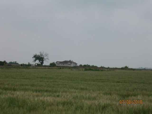
| 8502 COUNTY ROAD 10 | WELD | 16 | 01 | 67 |
| Account | Parcel | Account Type | Tax Year | Buildings | Actual Value | Local Govt Assessed Value | School Assessed Value |
|---|---|---|---|---|---|---|---|
| R7437697 | 146916100080 | Agricultural | 2026 | 2 | 550,602 | 37,150 | 41,450 |
| Account | Owner Name | Address |
|---|---|---|
| R7437697 | VEIT DOLF C | 8502 COUNTY ROAD 10 FORT LUPTON, CO 806218112 |
| R7437697 | VEIT SUSAN A |
| Account | Parcel | Account Type | Tax Year | Buildings | Actual Value | Local Govt Assessed Value | School Assessed Value |
|---|---|---|---|---|---|---|---|
| R7437697 | 146916100080 | Agricultural | 2026 | 2 | 550,602 | 37,150 | 41,450 |
| Reception | Rec Date | Type | Grantor | Grantee | Doc Fee | Sale Date | Sale Price |
|---|---|---|---|---|---|---|---|
| 2558613 | 07-17-1997 | WD | MATLOCK WILLIAM T | BOUDREAUX THEO L | 7.50 | 07-16-1997 | 75,000 |
| 2676755 | 03-01-1999 | WD | BOUDREAUX THEO L | VEIT DOLF C & SUSAN A | 9.50 | 02-26-1999 | 95,000 |
*If the hyperlink for the reception number does not work, try a manual search in the Clerk and Recorder records. Use the Grantor or Grantee in your search.
| Account | Parcel | Account Type | Tax Year | Buildings | Actual Value | Local Govt Assessed Value | School Assessed Value |
|---|---|---|---|---|---|---|---|
| R7437697 | 146916100080 | Agricultural | 2026 | 2 | 550,602 | 37,150 | 41,450 |
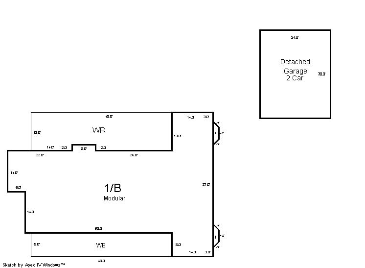
Building 1
| AccountNo | Building ID | Occupancy |
|---|---|---|
| R7437697 | 1 | Single Family Residential on Ag |
| ID | Type | NBHD | Occupancy | % Complete | Bedrooms | Baths |
|---|---|---|---|---|---|---|
| 1 | Residential | 4R0011 | Single Family Residential on Ag | 100 | 3 | 3.00 |
| ID | Exterior | Roof Cover | Interior | HVAC | Perimeter | Units | Unit Type | Make |
|---|---|---|---|---|---|---|---|---|
| 1 | Frame Siding | Composition Shingle | Drywall | Central Air to Air | 0 | 0 | NA | NA |
| ID | Square Ft | Condo SF | Total Basement SF | Finished Basement SF | Garage SF | Carport SF | Balcony SF | Porch SF |
|---|---|---|---|---|---|---|---|---|
| 1 | 2,210 | 0 | 2,186 | 0 | 720 | 0 | 992 | 0 |
| ID | Built As | Square Ft | Year Built | Stories | Length | Width |
|---|---|---|---|---|---|---|
| 1.00 | Modular 1 Story | 2,210 | 1999 | 1 | 0 | 0 |
| ID | Detail Type | Description | Units |
|---|---|---|---|
| 1 | Add On | Fireplace Wood | 1.00 |
| 1 | Balcony | Wood Wood Fin | 992.00 |
| 1 | Basement | Total Basement SF | 2186.00 |
| 1 | Fixture | Full Bath | 2.00 |
| 1 | Fixture | Half Bath | 1.00 |
| 1 | Garage | Detached | 720.00 |
Building 2
| AccountNo | Building ID | Occupancy |
|---|---|---|
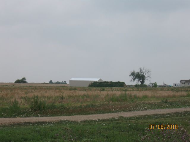
| R7437697 | 2 | Equipment Building |
| ID | Type | NBHD | Occupancy | % Complete | Bedrooms | Baths |
|---|---|---|---|---|---|---|
| 2 | Out Building | NA | Equipment Building | 100 | 0 | 0.00 |
| ID | Exterior | Roof Cover | Interior | HVAC | Perimeter | Units | Unit Type | Make |
|---|---|---|---|---|---|---|---|---|
| 2 | NA | NA | NA | None | 176 | 0 | NA | NA |
| ID | Square Ft | Condo SF | Total Basement SF | Finished Basement SF | Garage SF | Carport SF | Balcony SF | Porch SF |
|---|---|---|---|---|---|---|---|---|
| 2 | 1,920 | 0 | 0 | 0 | 0 | 0 | 0 | 0 |
| ID | Built As | Square Ft | Year Built | Stories | Length | Width |
|---|---|---|---|---|---|---|
| 2.00 | Equipment Building | 1,920 | 2009 | 1 | 48 | 40 |
No Additional Details for Building 2
| Account | Parcel | Account Type | Tax Year | Buildings | Actual Value | Local Govt Assessed Value | School Assessed Value |
|---|---|---|---|---|---|---|---|
| R7437697 | 146916100080 | Agricultural | 2026 | 2 | 550,602 | 37,150 | 41,450 |
| Type | Code | Description | Actual Value | Local Govt Assessed Value | School Assessed Value | Acres | Land SqFt |
|---|---|---|---|---|---|---|---|
| Improvement | 4277 | FARM/RANCH RESIDENCE-IMPS | 537,410 | 33,590 | 37,890 | 0.000 | 0 |
| Improvement | 4279 | FARM RANCH SUPPORT BLDGS | 10,349 | 2,790 | 2,790 | 0.000 | 0 |
| Land | 4127 | DRY FARM LAND-AGRICULTURAL | 2,843 | 770 | 770 | 18.710 | 815,008 |
| Totals | - | - | 550,602 | 37,150 | 41,450 | 18.710 | 815,008 |
Comparable sales for your Residential or Commercial property may be found using our SALES SEARCH TOOL
Values are updated annually on May 1st for Real Property and June 15th for Personal Property and Oil and Gas.
| Account | Parcel | Account Type | Tax Year | Buildings | Actual Value | Local Govt Assessed Value | School Assessed Value |
|---|---|---|---|---|---|---|---|
| R7437697 | 146916100080 | Agricultural | 2026 | 2 | 550,602 | 37,150 | 41,450 |
| Tax Area | District ID | District Name | Local Govt Mill Levy |
School Mill Levy |
Estimated Taxes |
|---|---|---|---|---|---|
| 4125 | 0700 | AIMS JUNIOR COLLEGE | 6.313 | 0.000 | $234.53 |
| 4125 | 0900 | CARBON VALLEY REC | 4.427 | 0.000 | $164.46 |
| 4125 | 0302 | CENTRAL COLORADO WATER (CCW) | 0.980 | 0.000 | $36.41 |
| 4125 | 0309 | CENTRAL COLORADO WATER SUBDISTRICT (CCS) | 1.462 | 0.000 | $54.31 |
| 4125 | 0305 | CENTRAL WELD COUNTY WATER (CWC) | 0.000 | 0.000 | $0.00 |
| 4125 | 0506 | FORT LUPTON FIRE | 9.357 | 0.000 | $347.61 |
| 4125 | 1050 | HIGH PLAINS LIBRARY | 3.044 | 0.000 | $113.08 |
| 4125 | 1202 | LONGMONT CONSERVATION | 0.000 | 0.000 | $0.00 |
| 4125 | 0301 | NORTHERN COLORADO WATER (NCW) | 1.000 | 0.000 | $37.15 |
| 4125 | 0208 | SCHOOL DIST RE8-FORT LUPTON AND DACONO | 0.000 | 18.198 | $754.31 |
| 4125 | 0100 | WELD COUNTY | 15.956 | 0.000 | $592.77 |
| Total | - | - | 42.539 | 18.198 | $2,334.63 |
The estimate of tax is based on the prior year mill levy and the 2025 projected assessment rates. Mill levies and tax estimates will be updated yearly on December 22nd for the current year. Additional information can be found at https://assessor.weld.gov