Account: R8077800
April 1, 2026
| Account | Parcel | Account Type | Tax Year | Buildings | Actual Value | Local Govt Assessed Value | School Assessed Value |
|---|---|---|---|---|---|---|---|
| R8077800 | 120729000090 | Residential | 2026 | 2 | 627,191 | 39,200 | 44,210 |
| Legal |
|---|
| PT NE4 29-3-68 BEG E4 COR S89D58'W 119.85' N06D06'W 30.27' N01D03'E 127.97' N07D14'E 144.86' N26D22'E 114.82' N46D59'E 35.86' S89D21'E 30' S0D38'W 428.73' TO POB (.36R) |
| Subdivision | Block | Lot | Land Economic Area |
|---|---|---|---|
| MEAD RURAL |
| Property Address | Property City | Section | Township | Range |
|---|---|---|---|---|
| 13515 COUNTY ROAD 5 | WELD | 29 | 03 | 68 |
| Account | Parcel | Account Type | Tax Year | Buildings | Actual Value | Local Govt Assessed Value | School Assessed Value |
|---|---|---|---|---|---|---|---|
| R8077800 | 120729000090 | Residential | 2026 | 2 | 627,191 | 39,200 | 44,210 |
| Account | Owner Name | Address |
|---|---|---|
| R8077800 | 13515 WELD COUNTY ROAD 5 LLC | 19349 COUNTY ROAD 25 LOT 4 BRUSH, CO 807239722 |
| Account | Parcel | Account Type | Tax Year | Buildings | Actual Value | Local Govt Assessed Value | School Assessed Value |
|---|---|---|---|---|---|---|---|
| R8077800 | 120729000090 | Residential | 2026 | 2 | 627,191 | 39,200 | 44,210 |
| Reception | Rec Date | Type | Grantor | Grantee | Doc Fee | Sale Date | Sale Price |
|---|---|---|---|---|---|---|---|
| 2205410 | 02-15-1990 | QCN | OLANDER DEAN L & DOROTHY A | DEAN L OLANDER CO & DOROTHY A OLANDER CO | 0.00 | 02-07-1990 | 0 |
| 2594752 | 02-18-1998 | SWDN | OLANDER DEAN L & DOROTHY ANN 1/2 INT & | DOROTHY A OLANDER FAMILY TURST | 0.00 | 02-12-1998 | 0 |
| 4360952 | 12-18-2017 | WDN | OLANDER DEAN L COMPANY; OLANDER DOROTHY A FAMILY TRUST | OLANDER RANDALL R | 0.00 | 11-01-1999 | 0 |
| 4360953 | 12-18-2017 | SWDN | OLANDER RANDALL R | OLANDER RANDALL LIVING TRUST | 0.00 | 12-14-2017 | 0 |
| 5040378 | 07-10-2025 | SWDN | OLANDER NANCY LIVING TRUST; OLANDER RANDALL LIVING TRUST | 13515 WELD COUNTY ROAD 5 LLC | 0.00 | 06-23-2025 | 0 |
*If the hyperlink for the reception number does not work, try a manual search in the Clerk and Recorder records. Use the Grantor or Grantee in your search.
| Account | Parcel | Account Type | Tax Year | Buildings | Actual Value | Local Govt Assessed Value | School Assessed Value |
|---|---|---|---|---|---|---|---|
| R8077800 | 120729000090 | Residential | 2026 | 2 | 627,191 | 39,200 | 44,210 |
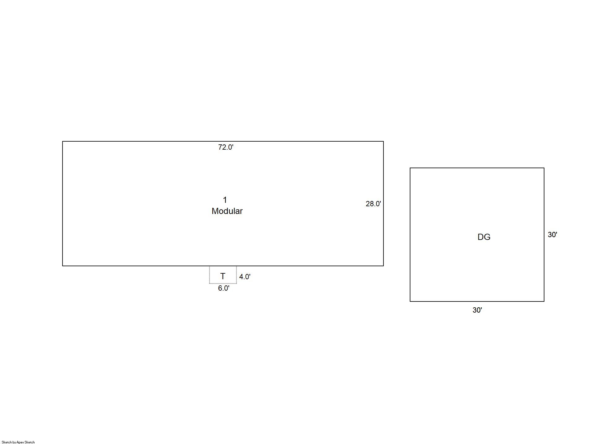
Building 1
| AccountNo | Building ID | Occupancy |
|---|---|---|
| R8077800 | 1 | Single Family Residential |
| ID | Type | NBHD | Occupancy | % Complete | Bedrooms | Baths |
|---|---|---|---|---|---|---|
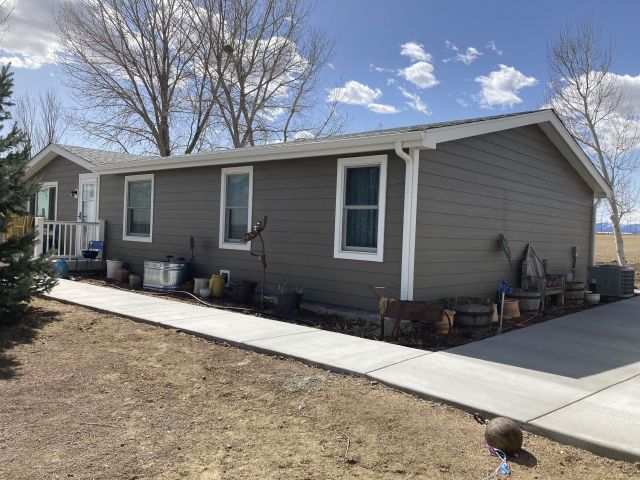
| 1 | Manufactured Hm | 3R0051 | Single Family Residential | 100 | 4 | 2.00 |
| ID | Exterior | Roof Cover | Interior | HVAC | Perimeter | Units | Unit Type | Make |
|---|---|---|---|---|---|---|---|---|
| 1 | Vinyl Siding | Composition Shingle | Drywall | Central Air to Air | 200 | 0 | NA | Redman |
| ID | Square Ft | Condo SF | Total Basement SF | Finished Basement SF | Garage SF | Carport SF | Balcony SF | Porch SF |
|---|---|---|---|---|---|---|---|---|
| 1 | 2,016 | 0 | 0 | 0 | 900 | 0 | 0 | 24 |
| ID | Built As | Square Ft | Year Built | Stories | Length | Width |
|---|---|---|---|---|---|---|
| 1.00 | Mnfctrd Home 1 Story | 2,016 | 1999 | 1 | 72 | 28 |
| ID | Detail Type | Description | Units |
|---|---|---|---|
| 1 | Fixture | Full Bath | 2.00 |
| 1 | Garage | Detached | 900.00 |
| 1 | Porch | Open Slab | 24.00 |
Building 2
| AccountNo | Building ID | Occupancy |
|---|---|---|
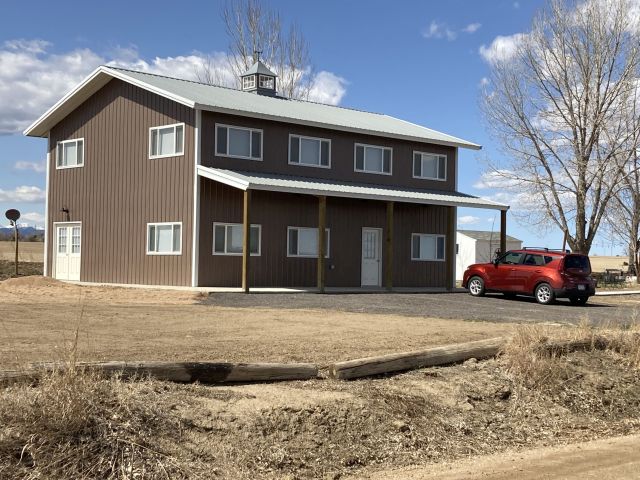
| R8077800 | 2 | Equipment Building |
| ID | Type | NBHD | Occupancy | % Complete | Bedrooms | Baths |
|---|---|---|---|---|---|---|
| 2 | Out Building | NA | Equipment Building | 100 | NA | 0.00 |
| ID | Exterior | Roof Cover | Interior | HVAC | Perimeter | Units | Unit Type | Make |
|---|---|---|---|---|---|---|---|---|
| 2 | Frame Aluminum | NA | Drywall | Radiant | 140 | 0 | NA | NA |
| ID | Square Ft | Condo SF | Total Basement SF | Finished Basement SF | Garage SF | Carport SF | Balcony SF | Porch SF |
|---|---|---|---|---|---|---|---|---|
| 2 | 1,200 | 0 | 0 | 0 | 0 | 0 | 0 | 0 |
| ID | Built As | Square Ft | Year Built | Stories | Length | Width |
|---|---|---|---|---|---|---|
| 2.00 | Equipment Building | 1,200 | 2021 | 2 | 40 | 30 |
| ID | Detail Type | Description | Units |
|---|---|---|---|
| 2 | Add On | Finished Space in OutBldg | 1200.00 |
| 2 | Add On | OB Loft | 1200.00 |
| 2 | Add On | Slab Roof Ceiling | 120.00 |
| Account | Parcel | Account Type | Tax Year | Buildings | Actual Value | Local Govt Assessed Value | School Assessed Value |
|---|---|---|---|---|---|---|---|
| R8077800 | 120729000090 | Residential | 2026 | 2 | 627,191 | 39,200 | 44,210 |
| Type | Code | Description | Actual Value | Local Govt Assessed Value | School Assessed Value | Acres | Land SqFt |
|---|---|---|---|---|---|---|---|
| Improvement | 1212 | SINGLE FAMILY RESIDENTIAL IMPROVEMENTS | 506,446 | 31,650 | 35,700 | 0.000 | 0 |
| Land | 1112 | SINGLE FAMILY RESIDENTIAL-LAND | 120,745 | 7,550 | 8,510 | 0.740 | 32,234 |
| Totals | - | - | 627,191 | 39,200 | 44,210 | 0.740 | 32,234 |
Comparable sales for your Residential or Commercial property may be found using our SALES SEARCH TOOL
Values are updated annually on May 1st for Real Property and June 15th for Personal Property and Oil and Gas.
| Account | Parcel | Account Type | Tax Year | Buildings | Actual Value | Local Govt Assessed Value | School Assessed Value |
|---|---|---|---|---|---|---|---|
| R8077800 | 120729000090 | Residential | 2026 | 2 | 627,191 | 39,200 | 44,210 |
| Tax Area | District ID | District Name | Local Govt Mill Levy |
School Mill Levy |
Estimated Taxes |
|---|---|---|---|---|---|
| 2325 | 1050 | HIGH PLAINS LIBRARY | 3.044 | 0.000 | $119.32 |
| 2325 | 1202 | LONGMONT CONSERVATION | 0.000 | 0.000 | $0.00 |
| 2325 | 0312 | LONGS PEAK WATER | 0.000 | 0.000 | $0.00 |
| 2325 | 0512 | MOUNTAIN VIEW FIRE PROTECTION DISTRICT | 16.342 | 0.000 | $640.61 |
| 2325 | 0301 | NORTHERN COLORADO WATER (NCW) | 1.000 | 0.000 | $39.20 |
| 2325 | 0213 | SCHOOL DIST RE1J-LONGMONT | 0.000 | 57.717 | $2,551.67 |
| 2325 | 0303 | ST VRAIN LEFT HAND WATER (SVW) | 1.406 | 0.000 | $55.12 |
| 2325 | 0100 | WELD COUNTY | 15.956 | 0.000 | $625.48 |
| Total | - | - | 37.748 | 57.717 | $4,031.39 |
The estimate of tax is based on the prior year mill levy and the 2025 projected assessment rates. Mill levies and tax estimates will be updated yearly on December 22nd for the current year. Additional information can be found at https://assessor.weld.gov