Account: R8456900
April 2, 2026
| Account | Parcel | Account Type | Tax Year | Buildings | Actual Value | Local Govt Assessed Value | School Assessed Value |
|---|---|---|---|---|---|---|---|
| R8456900 | 131113202005 | Agricultural | 2026 | 1 | 359,530 | 22,470 | 25,350 |
| Legal |
|---|
| IMPS ONLY ON PT N2 13-2-67 L15 & 16 LUPTON MEADOW DIV 1 EXC UPRR RES & EXC 6.06 AC AG&M TO GWS CO (LAND PARCEL 131113202005) 9990 23 CR WELD 0 |
| Subdivision | Block | Lot | Land Economic Area |
|---|---|---|---|
| LUPTON MEADOWS LAND CO DIV #1 | 15 |
| Property Address | Property City | Section | Township | Range |
|---|---|---|---|---|
| 9990 COUNTY ROAD 23 | WELD | 13 | 02 | 67 |
| Account | Parcel | Account Type | Tax Year | Buildings | Actual Value | Local Govt Assessed Value | School Assessed Value |
|---|---|---|---|---|---|---|---|
| R8456900 | 131113202005 | Agricultural | 2026 | 1 | 359,530 | 22,470 | 25,350 |
| Account | Owner Name | Address |
|---|---|---|
| R8456900 | WAGNER GERALD | 9990 COUNTY ROAD 23 FORT LUPTON, CO 806219304 |
| R8456900 | WAGNER TAWNYA |
| Account | Parcel | Account Type | Tax Year | Buildings | Actual Value | Local Govt Assessed Value | School Assessed Value |
|---|---|---|---|---|---|---|---|
| R8456900 | 131113202005 | Agricultural | 2026 | 1 | 359,530 | 22,470 | 25,350 |
No documents found.
| Account | Parcel | Account Type | Tax Year | Buildings | Actual Value | Local Govt Assessed Value | School Assessed Value |
|---|---|---|---|---|---|---|---|
| R8456900 | 131113202005 | Agricultural | 2026 | 1 | 359,530 | 22,470 | 25,350 |
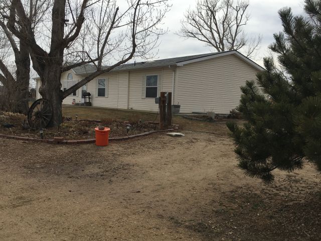
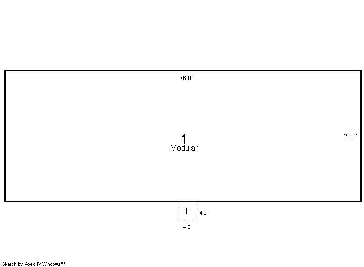
Building 1
| AccountNo | Building ID | Occupancy |
|---|---|---|
| R8456900 | 1 | Single Family Residential on Ag |
| ID | Type | NBHD | Occupancy | % Complete | Bedrooms | Baths |
|---|---|---|---|---|---|---|
| 1 | Residential | 4R1016 | Single Family Residential on Ag | 100 | 3 | 2.00 |
| ID | Exterior | Roof Cover | Interior | HVAC | Perimeter | Units | Unit Type | Make |
|---|---|---|---|---|---|---|---|---|
| 1 | Frame Siding | Composition Shingle | Drywall | Forced Air | 0 | 0 | NA | NA |
| ID | Square Ft | Condo SF | Total Basement SF | Finished Basement SF | Garage SF | Carport SF | Balcony SF | Porch SF |
|---|---|---|---|---|---|---|---|---|
| 1 | 2,128 | 0 | 0 | 0 | 0 | 0 | 0 | 16 |
| ID | Built As | Square Ft | Year Built | Stories | Length | Width |
|---|---|---|---|---|---|---|
| 1.00 | Modular 1 Story | 2,128 | 1999 | 1 | 0 | 0 |
| ID | Detail Type | Description | Units |
|---|---|---|---|
| 1 | Fixture | Full Bath | 2.00 |
| 1 | Porch | Open Slab | 16.00 |
| Account | Parcel | Account Type | Tax Year | Buildings | Actual Value | Local Govt Assessed Value | School Assessed Value |
|---|---|---|---|---|---|---|---|
| R8456900 | 131113202005 | Agricultural | 2026 | 1 | 359,530 | 22,470 | 25,350 |
| Type | Code | Description | Actual Value | Local Govt Assessed Value | School Assessed Value | Acres | Land SqFt |
|---|---|---|---|---|---|---|---|
| Improvement | 4277 | FARM/RANCH RESIDENCE-IMPS | 359,530 | 22,470 | 25,350 | 0.000 | 0 |
| Totals | - | - | 359,530 | 22,470 | 25,350 | 0.000 | 0 |
Comparable sales for your Residential or Commercial property may be found using our SALES SEARCH TOOL
Values are updated annually on May 1st for Real Property and June 15th for Personal Property and Oil and Gas.
| Account | Parcel | Account Type | Tax Year | Buildings | Actual Value | Local Govt Assessed Value | School Assessed Value |
|---|---|---|---|---|---|---|---|
| R8456900 | 131113202005 | Agricultural | 2026 | 1 | 359,530 | 22,470 | 25,350 |
| Tax Area | District ID | District Name | Local Govt Mill Levy |
School Mill Levy |
Estimated Taxes |
|---|---|---|---|---|---|
| 4569 | 0700 | AIMS JUNIOR COLLEGE | 6.313 | 0.000 | $141.85 |
| 4569 | 0313 | CENTRAL COLO WATER WELL (CCA) | 9.152 | 0.000 | $205.65 |
| 4569 | 0302 | CENTRAL COLORADO WATER (CCW) | 0.980 | 0.000 | $22.02 |
| 4569 | 0506 | FORT LUPTON FIRE | 9.357 | 0.000 | $210.25 |
| 4569 | 1050 | HIGH PLAINS LIBRARY | 3.044 | 0.000 | $68.40 |
| 4569 | 0301 | NORTHERN COLORADO WATER (NCW) | 1.000 | 0.000 | $22.47 |
| 4569 | 1201 | PLATTE VALLEY CONSERVATION | 0.000 | 0.000 | $0.00 |
| 4569 | 0208 | SCHOOL DIST RE8-FORT LUPTON AND DACONO | 0.000 | 18.198 | $461.32 |
| 4569 | 0100 | WELD COUNTY | 15.956 | 0.000 | $358.53 |
| Total | - | - | 45.802 | 18.198 | $1,490.49 |
The estimate of tax is based on the prior year mill levy and the 2025 projected assessment rates. Mill levies and tax estimates will be updated yearly on December 22nd for the current year. Additional information can be found at https://assessor.weld.gov