Account: R8747600
April 2, 2026
| Account | Parcel | Account Type | Tax Year | Buildings | Actual Value | Local Govt Assessed Value | School Assessed Value |
|---|---|---|---|---|---|---|---|
| R8747600 | 146921000079 | Agricultural | 2026 | 1 | 942,530 | 58,910 | 66,450 |
| Legal |
|---|
| PT NE4 21-1-67 LOT B REC EXEMPT RE-2214 EXC THAT PT OF FOLLOWING DESC LAND LYING WITH IN THIS PARCEL BEG NE COR SEC S45D30W 453.55' TO WLY ROW CR 19 & TPOB TH S43D15W 101.45' TH ALG CURVE TO L (R=250) CHORD=S22D06W 180.44' TO WLY ROW CR 19 TH ALG CURVE TO R (R=210) CHORD=N18D50E 79.76' TH N29D47E 33.26' TH ALG CURVE TO R (R=947) CHORD=N34D50E 166.56' TO TPOB (7.89RES) |
| Subdivision | Block | Lot | Land Economic Area |
|---|---|---|---|
| SW ECON 4 RURAL |
| Property Address | Property City | Section | Township | Range |
|---|---|---|---|---|
| 8741 COUNTY ROAD 8 | WELD | 21 | 01 | 67 |
| Account | Parcel | Account Type | Tax Year | Buildings | Actual Value | Local Govt Assessed Value | School Assessed Value |
|---|---|---|---|---|---|---|---|
| R8747600 | 146921000079 | Agricultural | 2026 | 1 | 942,530 | 58,910 | 66,450 |
| Account | Owner Name | Address |
|---|---|---|
| R8747600 | BAUER AMY B | 8741 COUNTY ROAD 8 BRIGHTON, CO 806038903 |
| R8747600 | BAUER MICHAEL R |
| Account | Parcel | Account Type | Tax Year | Buildings | Actual Value | Local Govt Assessed Value | School Assessed Value |
|---|---|---|---|---|---|---|---|
| R8747600 | 146921000079 | Agricultural | 2026 | 1 | 942,530 | 58,910 | 66,450 |
| Reception | Rec Date | Type | Grantor | Grantee | Doc Fee | Sale Date | Sale Price |
|---|---|---|---|---|---|---|---|
| 2635490 | 08-25-1998 | RE | RE-2214 | RE-2214 | 0.00 | 08-25-1998 | 0 |
| 2635490 | 08-25-1998 | RE | RECORDED EXEMPTION | RE-2214 | 0.00 | NA | 0 |
| 3810102 | 12-06-2011 | WD | MATLOCK WILLIAM T | BAUER AMY B | 11.50 | 12-05-2011 | 115,000 |
*If the hyperlink for the reception number does not work, try a manual search in the Clerk and Recorder records. Use the Grantor or Grantee in your search.
| Account | Parcel | Account Type | Tax Year | Buildings | Actual Value | Local Govt Assessed Value | School Assessed Value |
|---|---|---|---|---|---|---|---|
| R8747600 | 146921000079 | Agricultural | 2026 | 1 | 942,530 | 58,910 | 66,450 |
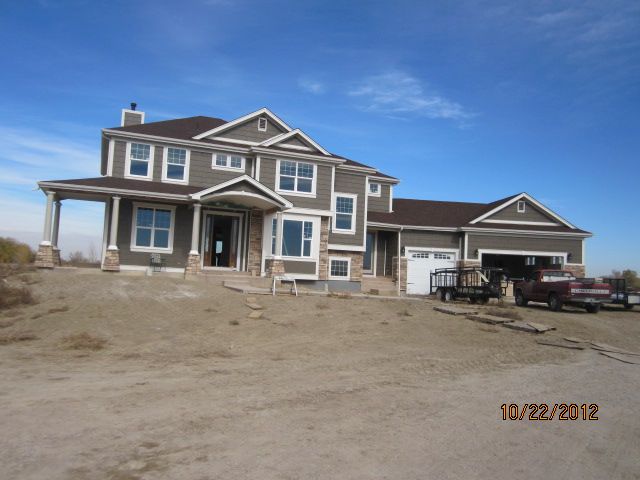
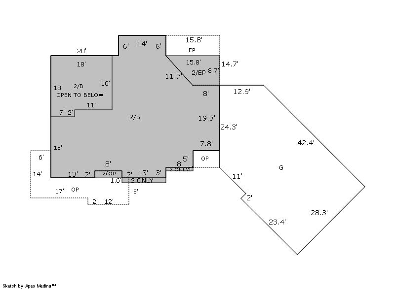
Building 1
| AccountNo | Building ID | Occupancy |
|---|---|---|
| R8747600 | 1 | Single Family Residential |
| ID | Type | NBHD | Occupancy | % Complete | Bedrooms | Baths |
|---|---|---|---|---|---|---|
| 1 | Residential | 4R0011 | Single Family Residential | 100 | 3 | 3.00 |
| ID | Exterior | Roof Cover | Interior | HVAC | Perimeter | Units | Unit Type | Make |
|---|---|---|---|---|---|---|---|---|
| 1 | Frame Siding | Composition Shingle | Drywall | Central Air to Air | 0 | 0 | NA | NA |
| ID | Square Ft | Condo SF | Total Basement SF | Finished Basement SF | Garage SF | Carport SF | Balcony SF | Porch SF |
|---|---|---|---|---|---|---|---|---|
| 1 | 3,187 | 0 | 1,670 | 0 | 1,214 | 0 | 0 | 199 |
| ID | Built As | Square Ft | Year Built | Stories | Length | Width |
|---|---|---|---|---|---|---|
| 1.00 | 2 Story | 3,187 | 2012 | 2 | 0 | 0 |
| ID | Detail Type | Description | Units |
|---|---|---|---|
| 1 | Add On | Fireplace Gas | 2.00 |
| 1 | Basement | Total Basement SF | 1670.00 |
| 1 | Fixture | Full Bath | 2.00 |
| 1 | Fixture | Half Bath | 1.00 |
| 1 | Garage | Attached | 1214.00 |
| 1 | Porch | Encl Solid Wall | 199.00 |
| 1 | Porch | Slab Roof Ceil | 301.00 |
| 1 | Rough In | Rough In | 1.00 |
| Account | Parcel | Account Type | Tax Year | Buildings | Actual Value | Local Govt Assessed Value | School Assessed Value |
|---|---|---|---|---|---|---|---|
| R8747600 | 146921000079 | Agricultural | 2026 | 1 | 942,530 | 58,910 | 66,450 |
| Type | Code | Description | Actual Value | Local Govt Assessed Value | School Assessed Value | Acres | Land SqFt |
|---|---|---|---|---|---|---|---|
| Improvement | 1212 | SINGLE FAMILY RESIDENTIAL IMPROVEMENTS | 695,164 | 43,450 | 49,010 | 0.000 | 0 |
| Land | 1112 | SINGLE FAMILY RESIDENTIAL-LAND | 247,366 | 15,460 | 17,440 | 6.360 | 277,042 |
| Totals | - | - | 942,530 | 58,910 | 66,450 | 6.360 | 277,042 |
Comparable sales for your Residential or Commercial property may be found using our SALES SEARCH TOOL
Values are updated annually on May 1st for Real Property and June 15th for Personal Property and Oil and Gas.
| Account | Parcel | Account Type | Tax Year | Buildings | Actual Value | Local Govt Assessed Value | School Assessed Value |
|---|---|---|---|---|---|---|---|
| R8747600 | 146921000079 | Agricultural | 2026 | 1 | 942,530 | 58,910 | 66,450 |
| Tax Area | District ID | District Name | Local Govt Mill Levy |
School Mill Levy |
Estimated Taxes |
|---|---|---|---|---|---|
| 2508 | 0700 | AIMS JUNIOR COLLEGE | 6.313 | 0.000 | $371.90 |
| 2508 | 0900 | CARBON VALLEY REC | 4.427 | 0.000 | $260.79 |
| 2508 | 0506 | FORT LUPTON FIRE | 9.357 | 0.000 | $551.22 |
| 2508 | 1050 | HIGH PLAINS LIBRARY | 3.044 | 0.000 | $179.32 |
| 2508 | 0208 | SCHOOL DIST RE8-FORT LUPTON AND DACONO | 0.000 | 18.198 | $1,209.26 |
| 2508 | 0100 | WELD COUNTY | 15.956 | 0.000 | $939.97 |
| 2508 | 1209 | WEST ADAMS CONSERVATION | 0.000 | 0.000 | $0.00 |
| Total | - | - | 39.097 | 18.198 | $3,512.46 |
The estimate of tax is based on the prior year mill levy and the 2025 projected assessment rates. Mill levies and tax estimates will be updated yearly on December 22nd for the current year. Additional information can be found at https://assessor.weld.gov