Account: R8946000
April 1, 2026
| Account | Parcel | Account Type | Tax Year | Buildings | Actual Value | Local Govt Assessed Value | School Assessed Value |
|---|---|---|---|---|---|---|---|
| R8946000 | 095718200056 | Agricultural | 2026 | 3 | 489,614 | 41,840 | 45,320 |
| Legal |
|---|
| N2 NW4 18-5-67 EXC PT BEG SW COR OF N2NW4 N89D20'E 30' TPOB TH N685.67' N65D26'E 29.69' S697.69' S89D20'W 27' TPOB AND N88.56' TPOB N325.21' N46.37'E 37.14 S338.36' S65.24'W 29.69' TPOB |
| Subdivision | Block | Lot | Land Economic Area |
|---|---|---|---|
| W GREELEY RURAL |
| Property Address | Property City | Section | Township | Range |
|---|---|---|---|---|
| 27780 COUNTY ROAD 13 | WELD | 18 | 05 | 67 |
| Account | Parcel | Account Type | Tax Year | Buildings | Actual Value | Local Govt Assessed Value | School Assessed Value |
|---|---|---|---|---|---|---|---|
| R8946000 | 095718200056 | Agricultural | 2026 | 3 | 489,614 | 41,840 | 45,320 |
| Account | Owner Name | Address |
|---|---|---|
| R8946000 | ANADARKO E&P ONSHORE LLC | ATTN: STEVE FISHER LAND SURFACE ROCKIES 1099 18TH ST DENVER, CO 802021908 |
| Account | Parcel | Account Type | Tax Year | Buildings | Actual Value | Local Govt Assessed Value | School Assessed Value |
|---|---|---|---|---|---|---|---|
| R8946000 | 095718200056 | Agricultural | 2026 | 3 | 489,614 | 41,840 | 45,320 |
| Reception | Rec Date | Type | Grantor | Grantee | Doc Fee | Sale Date | Sale Price |
|---|---|---|---|---|---|---|---|
| 4214426 | 06-27-2016 | WD | WELD 34 LLC | DLS LAND COMPANY LLC | 337.50 | 06-24-2016 | 3,375,000 |
| 4226418 | 08-09-2016 | SURV | SURVEY | SURVEY | 0.00 | 07-25-2016 | 0 |
| 4385806 | 03-27-2018 | SWDN | DLS LAND COMPANY LLC | ANADARKO E&P ONSHORE LLC | 0.00 | 03-23-2018 | 0 |
*If the hyperlink for the reception number does not work, try a manual search in the Clerk and Recorder records. Use the Grantor or Grantee in your search.
| Account | Parcel | Account Type | Tax Year | Buildings | Actual Value | Local Govt Assessed Value | School Assessed Value |
|---|---|---|---|---|---|---|---|
| R8946000 | 095718200056 | Agricultural | 2026 | 3 | 489,614 | 41,840 | 45,320 |
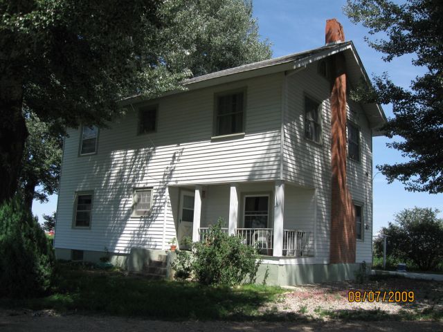
Building 1
| AccountNo | Building ID | Occupancy |
|---|---|---|
| R8946000 | 1 | Single Family Residential on Ag |
| ID | Type | NBHD | Occupancy | % Complete | Bedrooms | Baths |
|---|---|---|---|---|---|---|
| 1 | Residential | 2R3011 | Single Family Residential on Ag | 100 | 3 | 1.00 |
| ID | Exterior | Roof Cover | Interior | HVAC | Perimeter | Units | Unit Type | Make |
|---|---|---|---|---|---|---|---|---|
| 1 | Frame Siding | Composition Shingle | Drywall | Forced Air | NA | 0 | NA | NA |
| ID | Square Ft | Condo SF | Total Basement SF | Finished Basement SF | Garage SF | Carport SF | Balcony SF | Porch SF |
|---|---|---|---|---|---|---|---|---|
| 1 | 2,030 | 0 | 0 | 0 | 0 | 0 | 0 | 126 |
| ID | Built As | Square Ft | Year Built | Stories | Length | Width |
|---|---|---|---|---|---|---|
| 1.00 | 2 Story | 2,030 | 1899 | 2 | 0 | 0 |
| ID | Detail Type | Description | Units |
|---|---|---|---|
| 1 | Add On | Fireplace Gas | 1.00 |
| 1 | Fixture | Full Bath | 1.00 |
| 1 | Porch | Ceiling | 126.00 |
| 1 | Porch | Open Slab | 271.00 |
| 1 | Porch | Solid Wall | 126.00 |
| 1 | Porch | Wood Roof | 246.00 |
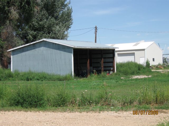
Building 2
| AccountNo | Building ID | Occupancy |
|---|---|---|
| R8946000 | 2 | Equipment Building |
| ID | Type | NBHD | Occupancy | % Complete | Bedrooms | Baths |
|---|---|---|---|---|---|---|
| 2 | Out Building | NA | Equipment Building | 100 | 0 | 0.00 |
| ID | Exterior | Roof Cover | Interior | HVAC | Perimeter | Units | Unit Type | Make |
|---|---|---|---|---|---|---|---|---|
| 2 | NA | NA | NA | None | 140 | 0 | NA | NA |
| ID | Square Ft | Condo SF | Total Basement SF | Finished Basement SF | Garage SF | Carport SF | Balcony SF | Porch SF |
|---|---|---|---|---|---|---|---|---|
| 2 | 1,200 | 0 | 0 | 0 | 0 | 0 | 0 | 0 |
| ID | Built As | Square Ft | Year Built | Stories | Length | Width |
|---|---|---|---|---|---|---|
| 2.00 | Equipment Building | 1,200 | 1995 | 1 | 40 | 30 |
No Additional Details for Building 2
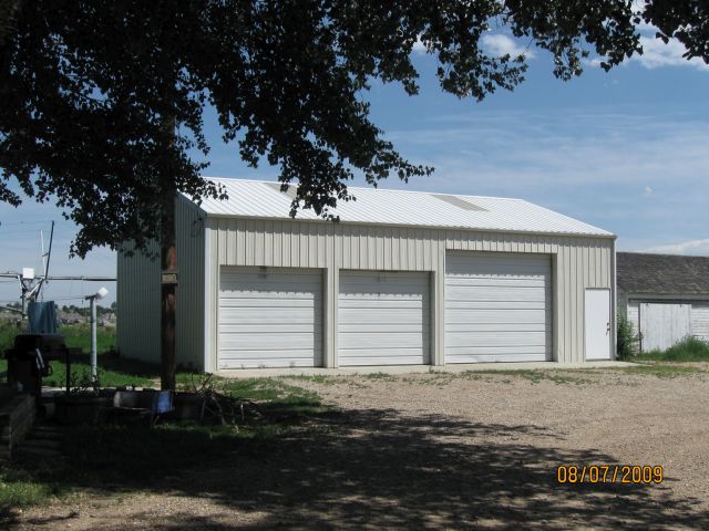
Building 3
| AccountNo | Building ID | Occupancy |
|---|---|---|
| R8946000 | 3 | Shed - Utility |
| ID | Type | NBHD | Occupancy | % Complete | Bedrooms | Baths |
|---|---|---|---|---|---|---|
| 3 | Out Building | NA | Shed - Utility | 100 | 0 | 0.00 |
| ID | Exterior | Roof Cover | Interior | HVAC | Perimeter | Units | Unit Type | Make |
|---|---|---|---|---|---|---|---|---|
| 3 | NA | NA | NA | None | 148 | 0 | NA | NA |
| ID | Square Ft | Condo SF | Total Basement SF | Finished Basement SF | Garage SF | Carport SF | Balcony SF | Porch SF |
|---|---|---|---|---|---|---|---|---|
| 3 | 1,170 | 0 | 0 | 0 | 0 | 0 | 0 | 0 |
| ID | Built As | Square Ft | Year Built | Stories | Length | Width |
|---|---|---|---|---|---|---|
| 3.00 | Shed - Utility | 1,170 | 1939 | 1 | 39 | 30 |
No Additional Details for Building 3
| Account | Parcel | Account Type | Tax Year | Buildings | Actual Value | Local Govt Assessed Value | School Assessed Value |
|---|---|---|---|---|---|---|---|
| R8946000 | 095718200056 | Agricultural | 2026 | 3 | 489,614 | 41,840 | 45,320 |
| Type | Code | Description | Actual Value | Local Govt Assessed Value | School Assessed Value | Acres | Land SqFt |
|---|---|---|---|---|---|---|---|
| Improvement | 1277 | PROPERTY NOT INTEGRAL TO AG - IMPROVEMENTS | 306,289 | 19,140 | 21,590 | 0.000 | 0 |
| Improvement | 4279 | FARM RANCH SUPPORT BLDGS | 18,073 | 4,880 | 4,880 | 0.000 | 0 |
| Land | 1177 | PROPERTY NOT INTEGRAL TO AG - LAND | 129,130 | 8,070 | 9,100 | 1.000 | 43,560 |
| Land | 4107 | SPRINKLER IRRIGATED LAND | 33,882 | 9,150 | 9,150 | 39.119 | 1,704,024 |
| Land | 4127 | DRY FARM LAND-AGRICULTURAL | 2,240 | 600 | 600 | 16.642 | 724,926 |
| Land | 4167 | WASTE LAND | 0 | 0 | 0 | 5.000 | 217,800 |
| Totals | - | - | 489,614 | 41,840 | 45,320 | 61.761 | 2,690,310 |
Comparable sales for your Residential or Commercial property may be found using our SALES SEARCH TOOL
Values are updated annually on May 1st for Real Property and June 15th for Personal Property and Oil and Gas.
| Account | Parcel | Account Type | Tax Year | Buildings | Actual Value | Local Govt Assessed Value | School Assessed Value |
|---|---|---|---|---|---|---|---|
| R8946000 | 095718200056 | Agricultural | 2026 | 3 | 489,614 | 41,840 | 45,320 |
| Tax Area | District ID | District Name | Local Govt Mill Levy |
School Mill Levy |
Estimated Taxes |
|---|---|---|---|---|---|
| 2362 | 0700 | AIMS JUNIOR COLLEGE | 6.313 | 0.000 | $264.14 |
| 2362 | 1050 | HIGH PLAINS LIBRARY | 3.044 | 0.000 | $127.36 |
| 2362 | 1206 | LARIMER CONSERVATION DISTRICT | 0.000 | 0.000 | $0.00 |
| 2362 | 0301 | NORTHERN COLORADO WATER (NCW) | 1.000 | 0.000 | $41.84 |
| 2362 | 0205 | SCHOOL DIST RE5J-JOHNSTOWN | 0.000 | 36.271 | $1,643.80 |
| 2362 | 0100 | WELD COUNTY | 15.956 | 0.000 | $667.60 |
| 2362 | 0521 | WINDSOR-SEVERANCE FIRE | 8.535 | 0.000 | $357.10 |
| Total | - | - | 34.848 | 36.271 | $3,101.84 |
The estimate of tax is based on the prior year mill levy and the 2025 projected assessment rates. Mill levies and tax estimates will be updated yearly on December 22nd for the current year. Additional information can be found at https://assessor.weld.gov