Account: R8951984
April 1, 2026
| Account | Parcel | Account Type | Tax Year | Buildings | Actual Value | Local Govt Assessed Value | School Assessed Value |
|---|---|---|---|---|---|---|---|
| R8951984 | 146733359005 | Commercial | 2026 | 1 | 1,756,616 | 474,280 | 474,280 |
| Legal |
|---|
| LOT 5A VISTA RIDGE FG 14, 4TH AMD MINOR SUB |
| Subdivision | Block | Lot | Land Economic Area |
|---|---|---|---|
| VISTA RIDGE FG 14, 4TH AMD MINOR SUB | 5A | VISTA RIDGE MARKETPLACE |
| Property Address | Property City | Section | Township | Range |
|---|---|---|---|---|
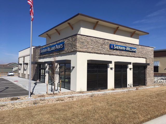
| 2325 HIGHWAY 7 | ERIE | 33 | 01 | 68 |
| Account | Parcel | Account Type | Tax Year | Buildings | Actual Value | Local Govt Assessed Value | School Assessed Value |
|---|---|---|---|---|---|---|---|
| R8951984 | 146733359005 | Commercial | 2026 | 1 | 1,756,616 | 474,280 | 474,280 |
| Account | Owner Name | Address |
|---|---|---|
| R8951984 | AGREE LIMITED PARTNERSHIP | 32301 WOODWARD AVE ROYAL OAK, MI 480730946 |
| Account | Parcel | Account Type | Tax Year | Buildings | Actual Value | Local Govt Assessed Value | School Assessed Value |
|---|---|---|---|---|---|---|---|
| R8951984 | 146733359005 | Commercial | 2026 | 1 | 1,756,616 | 474,280 | 474,280 |
| Reception | Rec Date | Type | Grantor | Grantee | Doc Fee | Sale Date | Sale Price |
|---|---|---|---|---|---|---|---|
| 4347550 | 10-27-2017 | PLT | VISTA RIDGE FG 14, 4TH AMD MINOR SUB | VISTA RIDGE FG 14, 4TH AMD MINOR SUB | 0.00 | 10-18-2017 | 0 |
| 4383425 | 03-16-2018 | SWD | SH7 MARKETPLACE INC | WDG ERIE LLC | 50.15 | 03-14-2018 | 501,500 |
| 4466449 | 02-12-2019 | SWD | WDG ERIE LLC | GLENWRIGHT THEODORE E 2005 TRUST | 274.00 | 02-11-2019 | 2,740,000 |
| 4543908 | 11-22-2019 | SURV | R68 T1 S33 SW4 | R68 T1 S33 SW4 | 0.00 | 11-20-2019 | 0 |
| 5080217 | 01-30-2026 | WD | GLENWRIGHT THEODORE E 2005 TRUST | AGREE LIMITED PARTNERSHIP | 255.50 | 01-29-2026 | 2,555,000 |
*If the hyperlink for the reception number does not work, try a manual search in the Clerk and Recorder records. Use the Grantor or Grantee in your search.
| Account | Parcel | Account Type | Tax Year | Buildings | Actual Value | Local Govt Assessed Value | School Assessed Value |
|---|---|---|---|---|---|---|---|
| R8951984 | 146733359005 | Commercial | 2026 | 1 | 1,756,616 | 474,280 | 474,280 |
Building 1
| AccountNo | Building ID | Occupancy |
|---|---|---|
| R8951984 | 1 | Retail |
| ID | Type | NBHD | Occupancy | % Complete | Bedrooms | Baths |
|---|---|---|---|---|---|---|
| 1 | Commercial | 3931 | Retail | 100 | NA | 0.00 |
| ID | Exterior | Roof Cover | Interior | HVAC | Perimeter | Units | Unit Type | Make |
|---|---|---|---|---|---|---|---|---|
| 1 | NA | NA | NA | Package Unit | 278 | 0 | NA | NA |
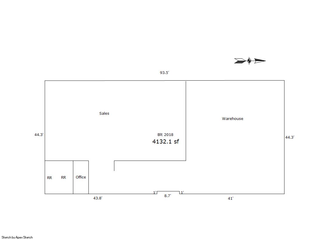
| ID | Square Ft | Condo SF | Total Basement SF | Finished Basement SF | Garage SF | Carport SF | Balcony SF | Porch SF |
|---|---|---|---|---|---|---|---|---|
| 1 | 4,132 | 0 | 0 | 0 | 0 | 0 | 0 | 0 |
| ID | Built As | Square Ft | Year Built | Stories | Length | Width |
|---|---|---|---|---|---|---|
| 1.00 | Retail Store | 4,132 | 2018 | 1 | 0 | 0 |
| ID | Detail Type | Description | Units |
|---|---|---|---|
| 1 | Add On | Asphalt Average | 7802.00 |
| 1 | Add On | Concrete Slab Average | 3440.00 |
| Account | Parcel | Account Type | Tax Year | Buildings | Actual Value | Local Govt Assessed Value | School Assessed Value |
|---|---|---|---|---|---|---|---|
| R8951984 | 146733359005 | Commercial | 2026 | 1 | 1,756,616 | 474,280 | 474,280 |
| Type | Code | Description | Actual Value | Local Govt Assessed Value | School Assessed Value | Acres | Land SqFt |
|---|---|---|---|---|---|---|---|
| Improvement | 2212 | MERCHANDISING-IMPROVEMENT | 1,255,160 | 338,890 | 338,890 | 0.000 | 0 |
| Land | 2112 | MERCHANDISING-LAND | 501,456 | 135,390 | 135,390 | 0.480 | 20,894 |
| Totals | - | - | 1,756,616 | 474,280 | 474,280 | 0.480 | 20,894 |
Comparable sales for your Residential or Commercial property may be found using our SALES SEARCH TOOL
Values are updated annually on May 1st for Real Property and June 15th for Personal Property and Oil and Gas.
| Account | Parcel | Account Type | Tax Year | Buildings | Actual Value | Local Govt Assessed Value | School Assessed Value |
|---|---|---|---|---|---|---|---|
| R8951984 | 146733359005 | Commercial | 2026 | 1 | 1,756,616 | 474,280 | 474,280 |
| Tax Area | District ID | District Name | Local Govt Mill Levy |
School Mill Levy |
Estimated Taxes |
|---|---|---|---|---|---|
| 3520 | 0404 | ERIE TOWN | 13.237 | 0.000 | $6,278.04 |
| 3520 | 1050 | HIGH PLAINS LIBRARY | 3.044 | 0.000 | $1,443.71 |
| 3520 | 0512 | MOUNTAIN VIEW FIRE PROTECTION DISTRICT | 16.342 | 0.000 | $7,750.68 |
| 3520 | 0301 | NORTHERN COLORADO WATER (NCW) | 1.000 | 0.000 | $474.28 |
| 3520 | 1360 | RTD | 0.000 | 0.000 | $0.00 |
| 3520 | 0213 | SCHOOL DIST RE1J-LONGMONT | 0.000 | 57.717 | $27,374.02 |
| 3520 | 1315 | VISTA RIDGE METRO DISTRICT | 47.000 | 0.000 | $22,291.16 |
| 3520 | 0100 | WELD COUNTY | 15.956 | 0.000 | $7,567.61 |
| Total | - | - | 96.579 | 57.717 | $73,179.51 |
The estimate of tax is based on the prior year mill levy and the 2025 projected assessment rates. Mill levies and tax estimates will be updated yearly on December 22nd for the current year. Additional information can be found at https://assessor.weld.gov