Account: R8960640
April 1, 2026
| Account | Parcel | Account Type | Tax Year | Buildings | Actual Value | Local Govt Assessed Value | School Assessed Value |
|---|---|---|---|---|---|---|---|
| R8960640 | 105326200005 | Agricultural | 2026 | 3 | 382,582 | 26,130 | 29,100 |
| Legal |
|---|
| PT NW4 26-4-64 LOT A AMD REC EXEMPT 1AMRECX18-07-4548 |
| Subdivision | Block | Lot | Land Economic Area |
|---|---|---|---|
| KERSEY RURAL |
| Property Address | Property City | Section | Township | Range |
|---|---|---|---|---|
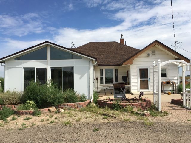
| 19970 COUNTY ROAD 57 | 26 | 04 | 64 |
| Account | Parcel | Account Type | Tax Year | Buildings | Actual Value | Local Govt Assessed Value | School Assessed Value |
|---|---|---|---|---|---|---|---|
| R8960640 | 105326200005 | Agricultural | 2026 | 3 | 382,582 | 26,130 | 29,100 |
| Account | Owner Name | Address |
|---|---|---|
| R8960640 | ALLEN CALVIN JR | 19970 COUNTY ROAD 57 KERSEY, CO 806449104 |
| R8960640 | ALLEN DEBRA J |
| Account | Parcel | Account Type | Tax Year | Buildings | Actual Value | Local Govt Assessed Value | School Assessed Value |
|---|---|---|---|---|---|---|---|
| R8960640 | 105326200005 | Agricultural | 2026 | 3 | 382,582 | 26,130 | 29,100 |
| Reception | Rec Date | Type | Grantor | Grantee | Doc Fee | Sale Date | Sale Price |
|---|---|---|---|---|---|---|---|
| 4489474 | 05-15-2019 | PLT | RECX 18 07 4548 AM1 | RECX 18 07 4548 AM1 | 0.00 | 05-09-2019 | 0 |
| 4735638 | 07-14-2021 | WD | DINNEL DONALD L; DINNEL PATRICIA PARKER; DINNEL MONROE DARLENE J | AMEN TODD A; AMEN RHONDA R | 42.50 | 07-12-2021 | 425,000 |
| 4929067 | 11-02-2023 | DTHC | DINNEL DALE FRANCIS | DINNEL DALE FRANCIS | 0.00 | 02-20-1999 | 0 |
| 4957884 | 05-01-2024 | WD | AMEN TODD A; AMEN RHONDA R | ALLEN CALVIN JR; ALLEN DEBRA J | 50.75 | 04-30-2024 | 507,500 |
*If the hyperlink for the reception number does not work, try a manual search in the Clerk and Recorder records. Use the Grantor or Grantee in your search.
| Account | Parcel | Account Type | Tax Year | Buildings | Actual Value | Local Govt Assessed Value | School Assessed Value |
|---|---|---|---|---|---|---|---|
| R8960640 | 105326200005 | Agricultural | 2026 | 3 | 382,582 | 26,130 | 29,100 |
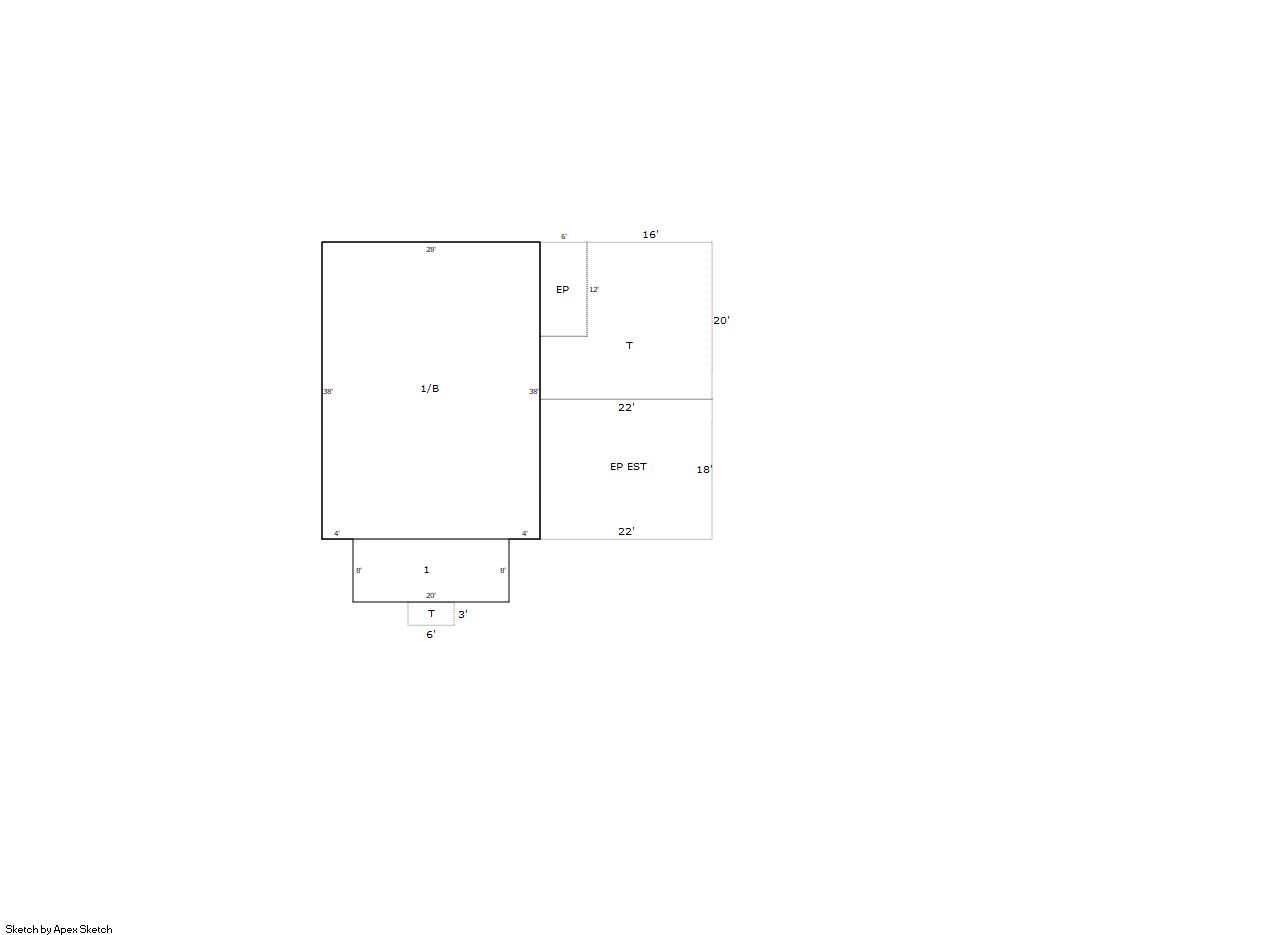
Building 1
| AccountNo | Building ID | Occupancy |
|---|---|---|
| R8960640 | 1 | Single Family Residential on Ag |
| ID | Type | NBHD | Occupancy | % Complete | Bedrooms | Baths |
|---|---|---|---|---|---|---|
| 1 | Residential | 6R2001 | Single Family Residential on Ag | 100 | 2 | 1.00 |
| ID | Exterior | Roof Cover | Interior | HVAC | Perimeter | Units | Unit Type | Make |
|---|---|---|---|---|---|---|---|---|
| 1 | Frame Vinyl | Composition Shingle | Drywall | Forced Air | 148 | 0 | NA | NA |
| ID | Square Ft | Condo SF | Total Basement SF | Finished Basement SF | Garage SF | Carport SF | Balcony SF | Porch SF |
|---|---|---|---|---|---|---|---|---|
| 1 | 1,224 | 0 | 1,064 | 1,064 | 0 | 0 | 0 | 468 |
| ID | Built As | Square Ft | Year Built | Stories | Length | Width |
|---|---|---|---|---|---|---|
| 1.00 | Ranch 1 Story | 1,224 | 1918 | 1 | 0 | 0 |
| ID | Detail Type | Description | Units |
|---|---|---|---|
| 1 | Basement | Finished | 1064.00 |
| 1 | Basement | Total Basement SF | 1064.00 |
| 1 | Fixture | Full Bath | 1.00 |
| 1 | Porch | Encl Solid Wall | 468.00 |
| 1 | Porch | Open Slab | 386.00 |
Building 2
| AccountNo | Building ID | Occupancy |
|---|---|---|
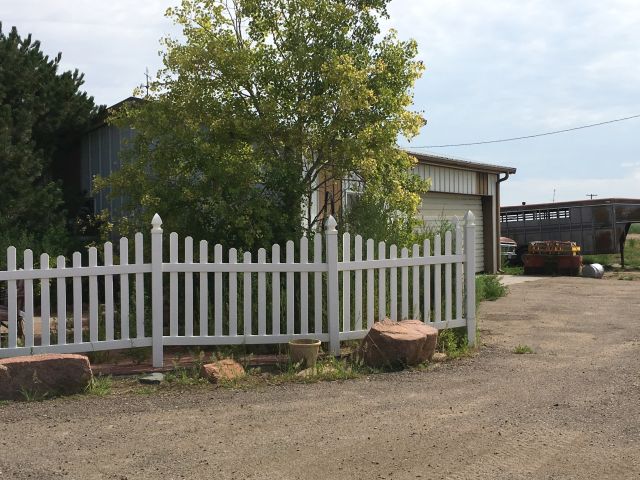
| R8960640 | 2 | Utility Building |
| ID | Type | NBHD | Occupancy | % Complete | Bedrooms | Baths |
|---|---|---|---|---|---|---|
| 2 | Out Building | NA | Utility Building | 100 | 0 | 0.00 |
| ID | Exterior | Roof Cover | Interior | HVAC | Perimeter | Units | Unit Type | Make |
|---|---|---|---|---|---|---|---|---|
| 2 | NA | NA | NA | None | 120 | 0 | NA | NA |
| ID | Square Ft | Condo SF | Total Basement SF | Finished Basement SF | Garage SF | Carport SF | Balcony SF | Porch SF |
|---|---|---|---|---|---|---|---|---|
| 2 | 864 | 0 | 0 | 0 | 0 | 0 | 0 | 0 |
| ID | Built As | Square Ft | Year Built | Stories | Length | Width |
|---|---|---|---|---|---|---|
| 2.00 | Utility Building | 864 | 1985 | 0 | 36 | 24 |
No Additional Details for Building 2
Building 3
| AccountNo | Building ID | Occupancy |
|---|---|---|
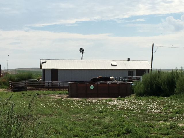
| R8960640 | 3 | Utility Building |
| ID | Type | NBHD | Occupancy | % Complete | Bedrooms | Baths |
|---|---|---|---|---|---|---|
| 3 | Out Building | NA | Utility Building | 100 | 0 | 0.00 |
| ID | Exterior | Roof Cover | Interior | HVAC | Perimeter | Units | Unit Type | Make |
|---|---|---|---|---|---|---|---|---|
| 3 | NA | NA | NA | None | 132 | 0 | NA | NA |
| ID | Square Ft | Condo SF | Total Basement SF | Finished Basement SF | Garage SF | Carport SF | Balcony SF | Porch SF |
|---|---|---|---|---|---|---|---|---|
| 3 | 800 | 0 | 0 | 0 | 0 | 0 | 0 | 0 |
| ID | Built As | Square Ft | Year Built | Stories | Length | Width |
|---|---|---|---|---|---|---|
| 3.00 | Utility Building | 800 | 1918 | 0 | 50 | 16 |
No Additional Details for Building 3
| Account | Parcel | Account Type | Tax Year | Buildings | Actual Value | Local Govt Assessed Value | School Assessed Value |
|---|---|---|---|---|---|---|---|
| R8960640 | 105326200005 | Agricultural | 2026 | 3 | 382,582 | 26,130 | 29,100 |
| Type | Code | Description | Actual Value | Local Govt Assessed Value | School Assessed Value | Acres | Land SqFt |
|---|---|---|---|---|---|---|---|
| Improvement | 4277 | FARM/RANCH RESIDENCE-IMPS | 371,904 | 23,240 | 26,220 | 0.000 | 0 |
| Improvement | 4279 | FARM RANCH SUPPORT BLDGS | 8,939 | 2,410 | 2,410 | 0.000 | 0 |
| Land | 4117 | FLOOD IRRIGATED LAND-AGRICULTURAL | 1,736 | 470 | 470 | 1.903 | 82,895 |
| Land | 4167 | WASTE LAND | 3 | 10 | 0 | 0.476 | 20,735 |
| Totals | - | - | 382,582 | 26,130 | 29,100 | 2.379 | 103,630 |
Comparable sales for your Residential or Commercial property may be found using our SALES SEARCH TOOL
Values are updated annually on May 1st for Real Property and June 15th for Personal Property and Oil and Gas.
| Account | Parcel | Account Type | Tax Year | Buildings | Actual Value | Local Govt Assessed Value | School Assessed Value |
|---|---|---|---|---|---|---|---|
| R8960640 | 105326200005 | Agricultural | 2026 | 3 | 382,582 | 26,130 | 29,100 |
| Tax Area | District ID | District Name | Local Govt Mill Levy |
School Mill Levy |
Estimated Taxes |
|---|---|---|---|---|---|
| 2469 | 0700 | AIMS JUNIOR COLLEGE | 6.313 | 0.000 | $164.96 |
| 2469 | 0302 | CENTRAL COLORADO WATER (CCW) | 0.980 | 0.000 | $25.61 |
| 2469 | 0309 | CENTRAL COLORADO WATER SUBDISTRICT (CCS) | 1.462 | 0.000 | $38.20 |
| 2469 | 0305 | CENTRAL WELD COUNTY WATER (CWC) | 0.000 | 0.000 | $0.00 |
| 2469 | 1050 | HIGH PLAINS LIBRARY | 3.044 | 0.000 | $79.54 |
| 2469 | 0301 | NORTHERN COLORADO WATER (NCW) | 1.000 | 0.000 | $26.13 |
| 2469 | 0515 | PLATTE VALLEY FIRE | 5.165 | 0.000 | $134.96 |
| 2469 | 0207 | SCHOOL DIST RE7-KERSEY | 0.000 | 11.014 | $320.51 |
| 2469 | 1208 | SOUTHEAST WELD CONSERVATION | 0.000 | 0.000 | $0.00 |
| 2469 | 0100 | WELD COUNTY | 15.956 | 0.000 | $416.93 |
| 2469 | 1200 | WEST GREELEY CONSERVATION | 0.414 | 0.000 | $10.82 |
| Total | - | - | 34.334 | 11.014 | $1,217.65 |
The estimate of tax is based on the prior year mill levy and the 2025 projected assessment rates. Mill levies and tax estimates will be updated yearly on December 22nd for the current year. Additional information can be found at https://assessor.weld.gov