Account: R8964105
April 5, 2026
| Account | Parcel | Account Type | Tax Year | Buildings | Actual Value | Local Govt Assessed Value | School Assessed Value |
|---|---|---|---|---|---|---|---|
| R8964105 | 120918300002 | Agricultural | 2026 | 2 | 1,006,917 | 74,600 | 82,200 |
| Legal |
|---|
| PT SE4SW4 18-3-67 LOT B REC EXEMPT RECX18-0173 |
| Subdivision | Block | Lot | Land Economic Area |
|---|---|---|---|
| MEAD RURAL |
| Property Address | Property City | Section | Township | Range |
|---|---|---|---|---|
| 6331 COUNTY ROAD 32 | WELD | 18 | 03 | 67 |
| Account | Parcel | Account Type | Tax Year | Buildings | Actual Value | Local Govt Assessed Value | School Assessed Value |
|---|---|---|---|---|---|---|---|
| R8964105 | 120918300002 | Agricultural | 2026 | 2 | 1,006,917 | 74,600 | 82,200 |
| Account | Owner Name | Address |
|---|---|---|
| R8964105 | BLISS EMILY | 6331 COUNTY ROAD 32 PLATTEVILLE, CO 806519000 |
| R8964105 | BLISS PAUL |
| Account | Parcel | Account Type | Tax Year | Buildings | Actual Value | Local Govt Assessed Value | School Assessed Value |
|---|---|---|---|---|---|---|---|
| R8964105 | 120918300002 | Agricultural | 2026 | 2 | 1,006,917 | 74,600 | 82,200 |
| Reception | Rec Date | Type | Grantor | Grantee | Doc Fee | Sale Date | Sale Price |
|---|---|---|---|---|---|---|---|
| 4549059 | 12-11-2019 | RE | RECX18 0173 | RECX18 0173 | 0.00 | 12-10-2019 | 0 |
| 4560256 | 01-22-2020 | QCN | BLISS INVESTMENT GROUP LLC | BLISS INVESTMENT GROUP LLC | 0.00 | 01-22-2020 | 0 |
| 4713899 | 05-11-2021 | QCN | BLISS INVESTMENT GROUP LLC | BLISS PAUL | 0.00 | 04-29-2021 | 0 |
| 4821335 | 04-25-2022 | AFFD | BLISS PAUL | BLISS PAUL | 0.00 | 04-22-2022 | 0 |
| 4891643 | 04-11-2023 | QCN | BLISS INVESTMENT GROUP LLC | BLISS EMILY | 0.00 | 04-11-2023 | 0 |
| 5077552 | 01-15-2026 | QCN | BLISS EMILY | BLISS PAUL; BLISS EMILY | 0.00 | 01-08-2026 | 0 |
*If the hyperlink for the reception number does not work, try a manual search in the Clerk and Recorder records. Use the Grantor or Grantee in your search.
| Account | Parcel | Account Type | Tax Year | Buildings | Actual Value | Local Govt Assessed Value | School Assessed Value |
|---|---|---|---|---|---|---|---|
| R8964105 | 120918300002 | Agricultural | 2026 | 2 | 1,006,917 | 74,600 | 82,200 |
Building 1
| AccountNo | Building ID | Occupancy |
|---|---|---|
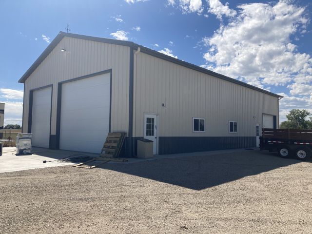
| R8964105 | 1 | Equipment Building |
| ID | Type | NBHD | Occupancy | % Complete | Bedrooms | Baths |
|---|---|---|---|---|---|---|
| 1 | Out Building | NA | Equipment Building | 100 | NA | 0.00 |
| ID | Exterior | Roof Cover | Interior | HVAC | Perimeter | Units | Unit Type | Make |
|---|---|---|---|---|---|---|---|---|
| 1 | NA | NA | NA | None | 220 | 0 | NA | NA |
| ID | Square Ft | Condo SF | Total Basement SF | Finished Basement SF | Garage SF | Carport SF | Balcony SF | Porch SF |
|---|---|---|---|---|---|---|---|---|
| 1 | 2,856 | 0 | 0 | 0 | 0 | 0 | 0 | 0 |
| ID | Built As | Square Ft | Year Built | Stories | Length | Width |
|---|---|---|---|---|---|---|
| 1.00 | Equipment Building | 2,856 | 2020 | 1 | 68 | 42 |
No Additional Details for Building 1
Building 2
| AccountNo | Building ID | Occupancy |
|---|---|---|
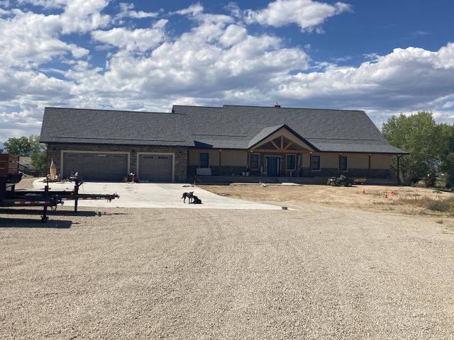
| R8964105 | 2 | Single Family Residential on Ag |
| ID | Type | NBHD | Occupancy | % Complete | Bedrooms | Baths |
|---|---|---|---|---|---|---|
| 2 | Residential | 3R2051 | Single Family Residential on Ag | 100 | 5 | 5.00 |
| ID | Exterior | Roof Cover | Interior | HVAC | Perimeter | Units | Unit Type | Make |
|---|---|---|---|---|---|---|---|---|
| 2 | Frame Stucco | Composition Shingle | Drywall | Central Air to Air | 359 | 0 | NA | NA |
| ID | Square Ft | Condo SF | Total Basement SF | Finished Basement SF | Garage SF | Carport SF | Balcony SF | Porch SF |
|---|---|---|---|---|---|---|---|---|
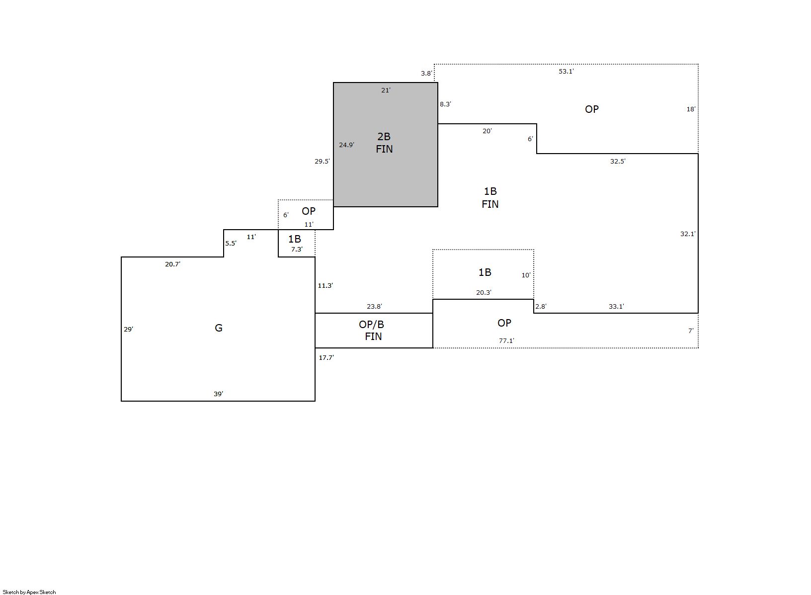
| 2 | 3,344 | 0 | 2,987 | 2,744 | 1,192 | 0 | 0 | 1487 |
| ID | Built As | Square Ft | Year Built | Stories | Length | Width |
|---|---|---|---|---|---|---|
| 2.00 | 1 1/2 Story Fin | 3,344 | 2021 | 2 | 0 | 0 |
| ID | Detail Type | Description | Units |
|---|---|---|---|
| 2 | Add On | Fireplace Gas | 1.00 |
| 2 | Basement | Finished | 2744.00 |
| 2 | Basement | Total Basement SF | 2987.00 |
| 2 | Fixture | Full Bath | 4.00 |
| 2 | Fixture | Half Bath | 1.00 |
| 2 | Garage | Attached | 1192.00 |
| 2 | Porch | Slab Roof Ceil | 1487.00 |
| Account | Parcel | Account Type | Tax Year | Buildings | Actual Value | Local Govt Assessed Value | School Assessed Value |
|---|---|---|---|---|---|---|---|
| R8964105 | 120918300002 | Agricultural | 2026 | 2 | 1,006,917 | 74,600 | 82,200 |
| Type | Code | Description | Actual Value | Local Govt Assessed Value | School Assessed Value | Acres | Land SqFt |
|---|---|---|---|---|---|---|---|
| Improvement | 4277 | FARM/RANCH RESIDENCE-IMPS | 950,712 | 59,420 | 67,030 | 0.000 | 0 |
| Improvement | 4279 | FARM RANCH SUPPORT BLDGS | 54,527 | 14,720 | 14,720 | 0.000 | 0 |
| Land | 4107 | SPRINKLER IRRIGATED LAND | 1,677 | 450 | 450 | 2.100 | 91,476 |
| Land | 4167 | WASTE LAND | 1 | 10 | 0 | 0.100 | 4,356 |
| Totals | - | - | 1,006,917 | 74,600 | 82,200 | 2.200 | 95,832 |
Comparable sales for your Residential or Commercial property may be found using our SALES SEARCH TOOL
Values are updated annually on May 1st for Real Property and June 15th for Personal Property and Oil and Gas.
| Account | Parcel | Account Type | Tax Year | Buildings | Actual Value | Local Govt Assessed Value | School Assessed Value |
|---|---|---|---|---|---|---|---|
| R8964105 | 120918300002 | Agricultural | 2026 | 2 | 1,006,917 | 74,600 | 82,200 |
| Tax Area | District ID | District Name | Local Govt Mill Levy |
School Mill Levy |
Estimated Taxes |
|---|---|---|---|---|---|
| 2309 | 1050 | HIGH PLAINS LIBRARY | 3.044 | 0.000 | $227.08 |
| 2309 | 0306 | LITTLE THOMPSON WATER (LTW) | 0.000 | 0.000 | $0.00 |
| 2309 | 1202 | LONGMONT CONSERVATION | 0.000 | 0.000 | $0.00 |
| 2309 | 0512 | MOUNTAIN VIEW FIRE PROTECTION DISTRICT | 16.342 | 0.000 | $1,219.11 |
| 2309 | 0301 | NORTHERN COLORADO WATER (NCW) | 1.000 | 0.000 | $74.60 |
| 2309 | 0213 | SCHOOL DIST RE1J-LONGMONT | 0.000 | 57.717 | $4,744.34 |
| 2309 | 0303 | ST VRAIN LEFT HAND WATER (SVW) | 1.406 | 0.000 | $104.89 |
| 2309 | 0100 | WELD COUNTY | 15.956 | 0.000 | $1,190.32 |
| Total | - | - | 37.748 | 57.717 | $7,560.34 |
The estimate of tax is based on the prior year mill levy and the 2025 projected assessment rates. Mill levies and tax estimates will be updated yearly on December 22nd for the current year. Additional information can be found at https://assessor.weld.gov