Account: R8965841
April 1, 2026
| Account | Parcel | Account Type | Tax Year | Buildings | Actual Value | Local Govt Assessed Value | School Assessed Value |
|---|---|---|---|---|---|---|---|
| R8965841 | 105103100001 | Agricultural | 2026 | 1 | 564,006 | 152,290 | 152,290 |
| Legal |
|---|
| ALL 3-4-63 INC FORMER UPRR R/W OF JULESBURG BRANCH LOCATED IN NE4 EXC 30AC N & E OF RR R/W ALSO EXC NW4SW4 ALSO EXC NE4SE4 ALSO EXC PT W2NW4 UNUSED RD ON W SIDE N2 |
| Subdivision | Block | Lot | Land Economic Area |
|---|---|---|---|
| ECON 6 T4-5 R61-63 RURAL |
| Property Address | Property City | Section | Township | Range |
|---|---|---|---|---|
| 03 | 04 | 63 |
| Account | Parcel | Account Type | Tax Year | Buildings | Actual Value | Local Govt Assessed Value | School Assessed Value |
|---|---|---|---|---|---|---|---|
| R8965841 | 105103100001 | Agricultural | 2026 | 1 | 564,006 | 152,290 | 152,290 |
| Account | Owner Name | Address |
|---|---|---|
| R8965841 | 70 RANCH LLC | 8301 E PRENTICE AVE STE 100 GREENWOOD VILLAGE, CO 801112904 |
| Account | Parcel | Account Type | Tax Year | Buildings | Actual Value | Local Govt Assessed Value | School Assessed Value |
|---|---|---|---|---|---|---|---|
| R8965841 | 105103100001 | Agricultural | 2026 | 1 | 564,006 | 152,290 | 152,290 |
No documents found.
| Account | Parcel | Account Type | Tax Year | Buildings | Actual Value | Local Govt Assessed Value | School Assessed Value |
|---|---|---|---|---|---|---|---|
| R8965841 | 105103100001 | Agricultural | 2026 | 1 | 564,006 | 152,290 | 152,290 |
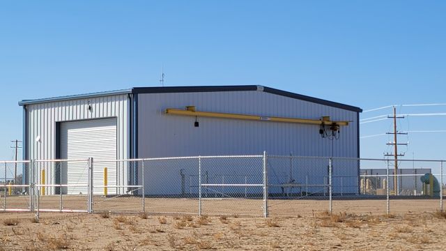
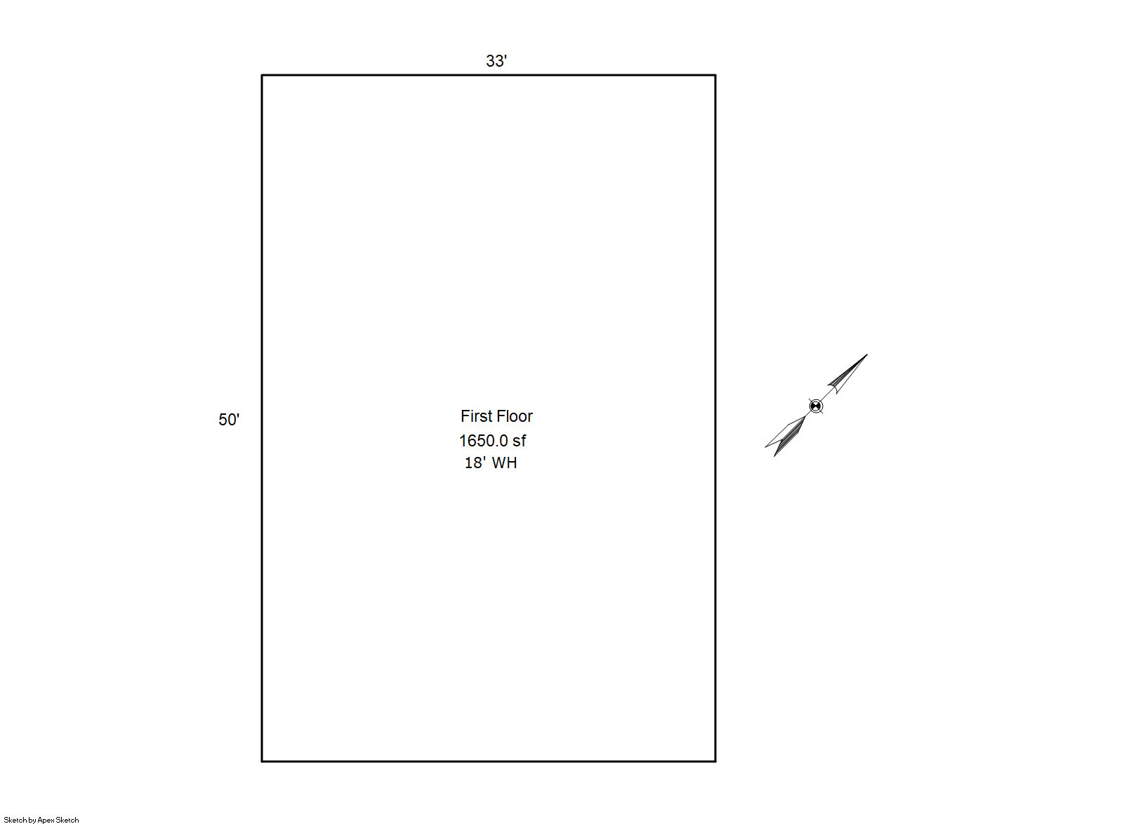
Building 1
| AccountNo | Building ID | Occupancy |
|---|---|---|
| R8965841 | 1 | Warehouse |
| ID | Type | NBHD | Occupancy | % Complete | Bedrooms | Baths |
|---|---|---|---|---|---|---|
| 1 | Commercial | 6915 | Warehouse | 100 | NA | 0.00 |
| ID | Exterior | Roof Cover | Interior | HVAC | Perimeter | Units | Unit Type | Make |
|---|---|---|---|---|---|---|---|---|
| 1 | NA | NA | NA | None | 166 | 0 | NA | NA |
| ID | Square Ft | Condo SF | Total Basement SF | Finished Basement SF | Garage SF | Carport SF | Balcony SF | Porch SF |
|---|---|---|---|---|---|---|---|---|
| 1 | 1,650 | 0 | 0 | 0 | 0 | 0 | 0 | 0 |
| ID | Built As | Square Ft | Year Built | Stories | Length | Width |
|---|---|---|---|---|---|---|
| 1.00 | Equipment Building-Commercial | 1,650 | 2020 | 1 | 0 | 0 |
No Additional Details for Building 1
| Account | Parcel | Account Type | Tax Year | Buildings | Actual Value | Local Govt Assessed Value | School Assessed Value |
|---|---|---|---|---|---|---|---|
| R8965841 | 105103100001 | Agricultural | 2026 | 1 | 564,006 | 152,290 | 152,290 |
| Type | Code | Description | Actual Value | Local Govt Assessed Value | School Assessed Value | Acres | Land SqFt |
|---|---|---|---|---|---|---|---|
| Improvement | 2235 | WAREHOUSE/STORAGE-IMPS | 57,612 | 15,560 | 15,560 | 0.000 | 0 |
| Land | 2135 | WAREHOUSE/STORAGE-LAND | 498,000 | 134,460 | 134,460 | 166.000 | 7,230,960 |
| Land | 4147 | GRAZING LAND-AGRICULTURAL | 8,361 | 2,260 | 2,260 | 266.000 | 11,586,960 |
| Land | 4167 | WASTE LAND | 33 | 10 | 10 | 18.000 | 784,080 |
| Totals | - | - | 564,006 | 152,290 | 152,290 | 450.000 | 19,602,000 |
Comparable sales for your Residential or Commercial property may be found using our SALES SEARCH TOOL
Values are updated annually on May 1st for Real Property and June 15th for Personal Property and Oil and Gas.
| Account | Parcel | Account Type | Tax Year | Buildings | Actual Value | Local Govt Assessed Value | School Assessed Value |
|---|---|---|---|---|---|---|---|
| R8965841 | 105103100001 | Agricultural | 2026 | 1 | 564,006 | 152,290 | 152,290 |
| Tax Area | District ID | District Name | Local Govt Mill Levy |
School Mill Levy |
Estimated Taxes |
|---|---|---|---|---|---|
| 6245 | 0700 | AIMS JUNIOR COLLEGE | 6.313 | 0.000 | $961.41 |
| 6245 | 0302 | CENTRAL COLORADO WATER (CCW) | 0.980 | 0.000 | $149.24 |
| 6245 | 0309 | CENTRAL COLORADO WATER SUBDISTRICT (CCS) | 1.462 | 0.000 | $222.65 |
| 6245 | 1050 | HIGH PLAINS LIBRARY | 3.044 | 0.000 | $463.57 |
| 6245 | 0301 | NORTHERN COLORADO WATER (NCW) | 1.000 | 0.000 | $152.29 |
| 6245 | 1675 | PLATTE RIVER METRO DISTRICT | 65.455 | 0.000 | $9,968.14 |
| 6245 | 0515 | PLATTE VALLEY FIRE | 5.165 | 0.000 | $786.58 |
| 6245 | 0207 | SCHOOL DIST RE7-KERSEY | 0.000 | 11.014 | $1,677.32 |
| 6245 | 0100 | WELD COUNTY | 15.956 | 0.000 | $2,429.94 |
| 6245 | 1200 | WEST GREELEY CONSERVATION | 0.414 | 0.000 | $63.05 |
| Total | - | - | 99.789 | 11.014 | $16,874.19 |
The estimate of tax is based on the prior year mill levy and the 2025 projected assessment rates. Mill levies and tax estimates will be updated yearly on December 22nd for the current year. Additional information can be found at https://assessor.weld.gov