Account: R8973435
April 5, 2026
| Account | Parcel | Account Type | Tax Year | Buildings | Actual Value | Local Govt Assessed Value | School Assessed Value |
|---|---|---|---|---|---|---|---|
| R8973435 | 054109400005 | Agricultural | 2026 | 1 | 838,501 | 226,400 | 226,400 |
| Legal |
|---|
| PT S2 9-8-60 DESC AS BEG SE COR SEC TH N0D12'E 30' S89D15'W 30' TO TPOB TH S89D15'W 2052.07' N0D12'E 743.06' N89D15'E 2052.07' S0D12'W 743.06 TO TPOB |
| Subdivision | Block | Lot | Land Economic Area |
|---|---|---|---|
| NE ECON 7 RURAL |
| Property Address | Property City | Section | Township | Range |
|---|---|---|---|---|
| 46039 COUNTY ROAD 103 | WELD | 09 | 08 | 60 |
| Account | Parcel | Account Type | Tax Year | Buildings | Actual Value | Local Govt Assessed Value | School Assessed Value |
|---|---|---|---|---|---|---|---|
| R8973435 | 054109400005 | Agricultural | 2026 | 1 | 838,501 | 226,400 | 226,400 |
| Account | Owner Name | Address |
|---|---|---|
| R8973435 | BISON IV PROPERTIES COLORADO LLC | 518 17TH ST STE 1800 DENVER, CO 802024117 |
| Account | Parcel | Account Type | Tax Year | Buildings | Actual Value | Local Govt Assessed Value | School Assessed Value |
|---|---|---|---|---|---|---|---|
| R8973435 | 054109400005 | Agricultural | 2026 | 1 | 838,501 | 226,400 | 226,400 |
| Reception | Rec Date | Type | Grantor | Grantee | Doc Fee | Sale Date | Sale Price |
|---|---|---|---|---|---|---|---|
| 4715937 | 05-17-2021 | SURV | SURVEY | SURVEY | 0.00 | 05-17-2021 | 0 |
| 4729257 | 06-24-2021 | PLT | MALLARD EXEMPTION PLAT | SURVEY | 0.00 | 05-11-2021 | 0 |
| 4729258 | 06-24-2021 | QCN | DPOC LLC | DPOC LLC | 0.00 | 06-22-2021 | 0 |
| 4758499 | 09-22-2021 | PLT | SURVEY | SURVEY | 0.00 | 08-17-2021 | 0 |
| 4758500 | 09-22-2021 | QCN | DPOC LLC | DPOC LLC | 0.00 | 08-17-2021 | 0 |
| 4807100 | 03-02-2022 | USR | USR21 0009 | USR21 0009 | 0.00 | 01-13-2022 | 0 |
| 4880759 | 02-08-2023 | OTH | DPOC LLC | BISON IV PROPERTIES COLORADO LLC | 0.00 | 02-08-2023 | 0 |
*If the hyperlink for the reception number does not work, try a manual search in the Clerk and Recorder records. Use the Grantor or Grantee in your search.
| Account | Parcel | Account Type | Tax Year | Buildings | Actual Value | Local Govt Assessed Value | School Assessed Value |
|---|---|---|---|---|---|---|---|
| R8973435 | 054109400005 | Agricultural | 2026 | 1 | 838,501 | 226,400 | 226,400 |
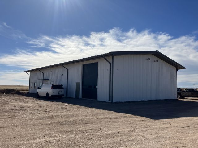
Building 1
| AccountNo | Building ID | Occupancy |
|---|---|---|
| R8973435 | 1 | Office Building |
| ID | Type | NBHD | Occupancy | % Complete | Bedrooms | Baths |
|---|---|---|---|---|---|---|
| 1 | Commercial | 7901 | Office Building | 100 | NA | 0.00 |
| ID | Exterior | Roof Cover | Interior | HVAC | Perimeter | Units | Unit Type | Make |
|---|---|---|---|---|---|---|---|---|
| 1 | NA | NA | NA | Package Unit | 290 | 0 | NA | NA |
| ID | Square Ft | Condo SF | Total Basement SF | Finished Basement SF | Garage SF | Carport SF | Balcony SF | Porch SF |
|---|---|---|---|---|---|---|---|---|
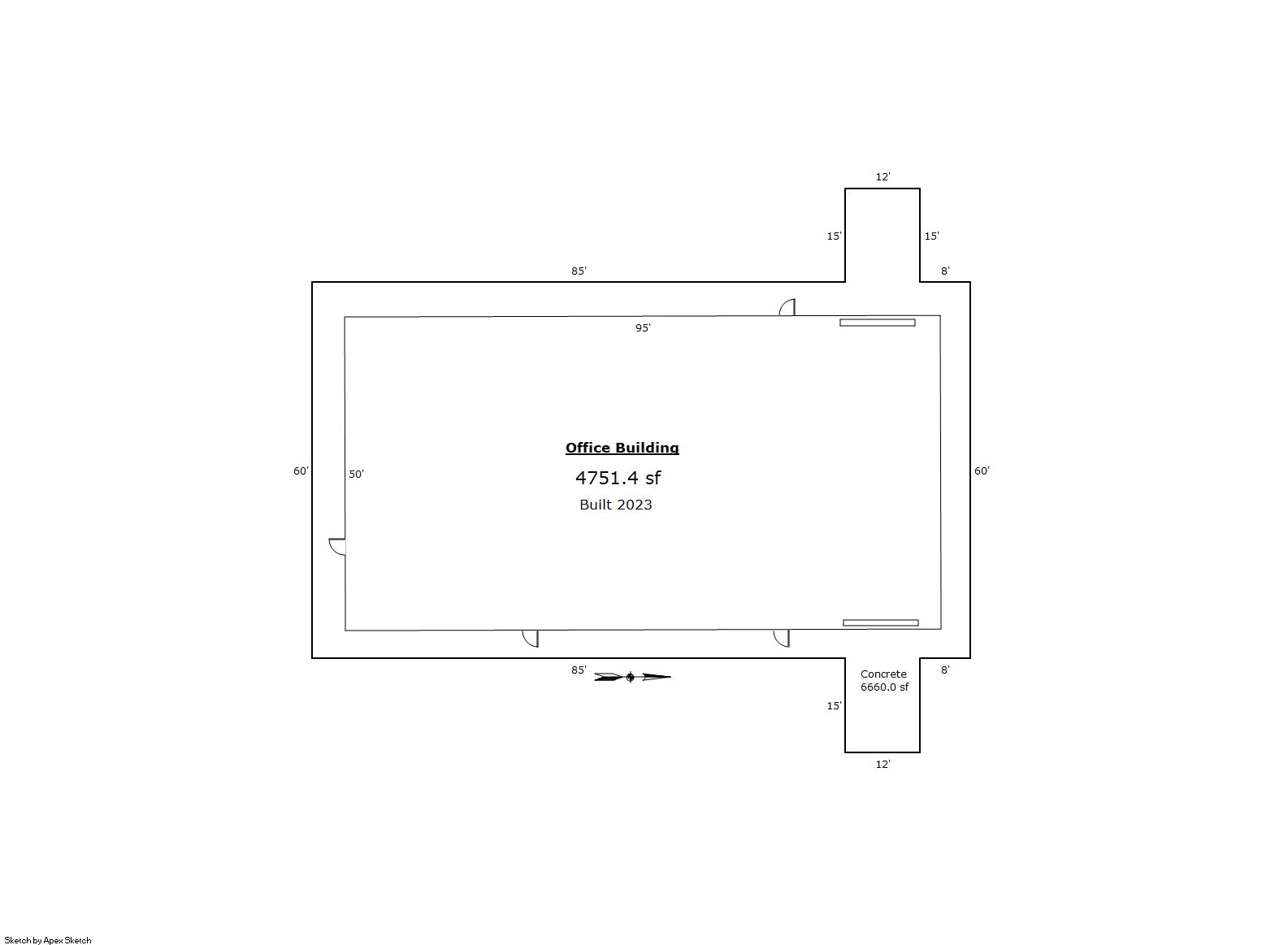
| 1 | 4,751 | 0 | 0 | 0 | 0 | 0 | 0 | 0 |
| ID | Built As | Square Ft | Year Built | Stories | Length | Width |
|---|---|---|---|---|---|---|
| 1.00 | Office Building | 4,751 | 2023 | 1 | 0 | 0 |
| ID | Detail Type | Description | Units |
|---|---|---|---|
| 1 | Add On | Concrete Slab Average | 6660.00 |
| 1 | Add On | Trash Enclosures Average | 1.00 |
| Account | Parcel | Account Type | Tax Year | Buildings | Actual Value | Local Govt Assessed Value | School Assessed Value |
|---|---|---|---|---|---|---|---|
| R8973435 | 054109400005 | Agricultural | 2026 | 1 | 838,501 | 226,400 | 226,400 |
| Type | Code | Description | Actual Value | Local Govt Assessed Value | School Assessed Value | Acres | Land SqFt |
|---|---|---|---|---|---|---|---|
| Improvement | 2220 | OFFICES-IMPROVEMENTS | 803,799 | 217,030 | 217,030 | 0.000 | 0 |
| Land | 2120 | OFFICES-LAND | 30,550 | 8,250 | 8,250 | 11.000 | 479,160 |
| Land | 4127 | DRY FARM LAND-AGRICULTURAL | 4,152 | 1,120 | 1,120 | 25.946 | 1,130,208 |
| Totals | - | - | 838,501 | 226,400 | 226,400 | 36.946 | 1,609,368 |
Comparable sales for your Residential or Commercial property may be found using our SALES SEARCH TOOL
Values are updated annually on May 1st for Real Property and June 15th for Personal Property and Oil and Gas.
| Account | Parcel | Account Type | Tax Year | Buildings | Actual Value | Local Govt Assessed Value | School Assessed Value |
|---|---|---|---|---|---|---|---|
| R8973435 | 054109400005 | Agricultural | 2026 | 1 | 838,501 | 226,400 | 226,400 |
| Tax Area | District ID | District Name | Local Govt Mill Levy |
School Mill Levy |
Estimated Taxes |
|---|---|---|---|---|---|
| 1007 | 0700 | AIMS JUNIOR COLLEGE | 6.313 | 0.000 | $1,429.26 |
| 1007 | 0524 | BRIGGSDALE FIRE | 4.002 | 0.000 | $906.05 |
| 1007 | 1050 | HIGH PLAINS LIBRARY | 3.044 | 0.000 | $689.16 |
| 1007 | 0210 | SCHOOL DIST RE10J-BRIGGSDALE | 0.000 | 16.616 | $3,761.86 |
| 1007 | 0100 | WELD COUNTY | 15.956 | 0.000 | $3,612.44 |
| 1007 | 1200 | WEST GREELEY CONSERVATION | 0.414 | 0.000 | $93.73 |
| Total | - | - | 29.729 | 16.616 | $10,492.51 |
The estimate of tax is based on the prior year mill levy and the 2025 projected assessment rates. Mill levies and tax estimates will be updated yearly on December 22nd for the current year. Additional information can be found at https://assessor.weld.gov