Account: R8979694
April 2, 2026
| Account | Parcel | Account Type | Tax Year | Buildings | Actual Value | Local Govt Assessed Value | School Assessed Value |
|---|---|---|---|---|---|---|---|
| R8979694 | 131116400027 | Agricultural | 2026 | 1 | 4,500 | 1,220 | 1,210 |
| Legal |
|---|
| PT SE4 16-2-67 COMM N4 SEC COR TH S11D21E 3178.9 S89D48E 95.29 TO POB TH S00D43W 1930.69 N89D16W 223.06 S00D43W 200 S89D16E 445.08 N00D43E 26.34 TH 111.25 ALG CRV TO R (R=375 CH=N09D13E) TH N17D43E 23.82 TH 145.92 ALG CRV TO R (R=178 CH=N41D12E) TH N64D41E 130.18 N47D47E 251.71 N45D33E 128.78 TH 144.96 ALG CRV TO L (R=245 CH=N28D36E) TH N11D39E 101.26 TH 83.51 ALG CRV TO R (R=140 CH=N28D45E) TH N45D50E 58.6 TH 70.33 ALG CRV TO L (R=350 CH=N40D04E) TH 45.72 ALG CRV TO L (R=60 CH=N12D29E) TH N09D19W 26.47 N00D05E 228.9 N00D22W 809.74 TH 51.54 ALG CRV TO L (R=150 CH=N10D13W) N89D48W 917.13 TO POB |
| Subdivision | Block | Lot | Land Economic Area |
|---|---|---|---|
| CENTRAL ECON 4 RURAL |
| Property Address | Property City | Section | Township | Range |
|---|---|---|---|---|
| 8405 COUNTY ROAD 20 | WELD | 16 | 02 | 67 |
| Account | Parcel | Account Type | Tax Year | Buildings | Actual Value | Local Govt Assessed Value | School Assessed Value |
|---|---|---|---|---|---|---|---|
| R8979694 | 131116400027 | Agricultural | 2026 | 1 | 4,500 | 1,220 | 1,210 |
| Account | Owner Name | Address |
|---|---|---|
| R8979694 | THOMAS JASON | 3206 COTTONWOOD CT MEAD, CO 805424581 |
| Account | Parcel | Account Type | Tax Year | Buildings | Actual Value | Local Govt Assessed Value | School Assessed Value |
|---|---|---|---|---|---|---|---|
| R8979694 | 131116400027 | Agricultural | 2026 | 1 | 4,500 | 1,220 | 1,210 |
| Reception | Rec Date | Type | Grantor | Grantee | Doc Fee | Sale Date | Sale Price |
|---|---|---|---|---|---|---|---|
| 4860713 | 10-12-2022 | SWDN | WCR 19 20 LLC | WCR 19 20 LLC | 0.00 | 02-01-2022 | 0 |
| 4879632 | 01-31-2023 | SWD | WCR 19-20 LLC | THOMAS JASON | 62.50 | 01-31-2023 | 625,000 |
*If the hyperlink for the reception number does not work, try a manual search in the Clerk and Recorder records. Use the Grantor or Grantee in your search.
| Account | Parcel | Account Type | Tax Year | Buildings | Actual Value | Local Govt Assessed Value | School Assessed Value |
|---|---|---|---|---|---|---|---|
| R8979694 | 131116400027 | Agricultural | 2026 | 1 | 4,500 | 1,220 | 1,210 |
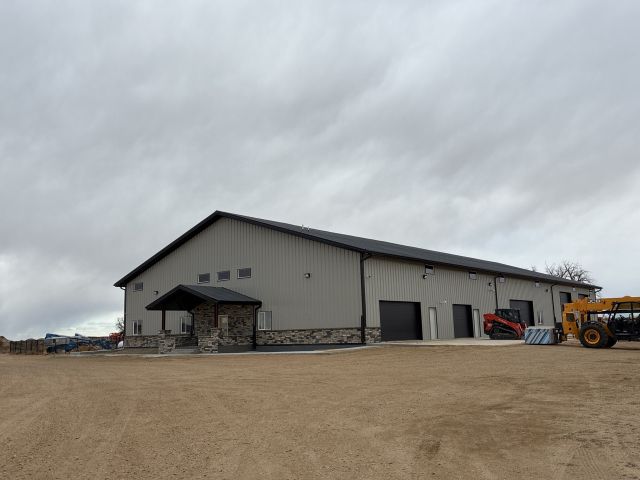
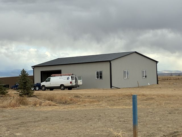
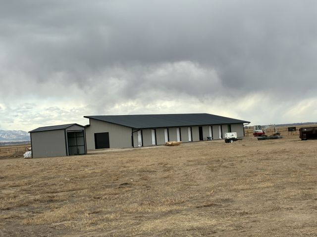
Building 1
| AccountNo | Building ID | Occupancy |
|---|---|---|
| R8979694 | 1 | Mixed Res w/ Outbldg |
| ID | Type | NBHD | Occupancy | % Complete | Bedrooms | Baths |
|---|---|---|---|---|---|---|
| 1 | Residential | 4R1016 | Mixed Res w/ Outbldg | 25 | NA | 0.00 |
| ID | Exterior | Roof Cover | Interior | HVAC | Perimeter | Units | Unit Type | Make |
|---|---|---|---|---|---|---|---|---|
| 1 | NA | NA | NA | NA | NA | 0 | NA | NA |
| ID | Square Ft | Condo SF | Total Basement SF | Finished Basement SF | Garage SF | Carport SF | Balcony SF | Porch SF |
|---|---|---|---|---|---|---|---|---|
| 1 | 1 | 0 | 0 | 0 | 0 | 0 | 0 | 0 |
| ID | Built As | Square Ft | Year Built | Stories | Length | Width |
|---|---|---|---|---|---|---|
| 1.00 | Permit Value | 1 | 2024 | 1 | 0 | 0 |
No Additional Details for Building 1
| Account | Parcel | Account Type | Tax Year | Buildings | Actual Value | Local Govt Assessed Value | School Assessed Value |
|---|---|---|---|---|---|---|---|
| R8979694 | 131116400027 | Agricultural | 2026 | 1 | 4,500 | 1,220 | 1,210 |
| Type | Code | Description | Actual Value | Local Govt Assessed Value | School Assessed Value | Acres | Land SqFt |
|---|---|---|---|---|---|---|---|
| Land | 4127 | DRY FARM LAND-AGRICULTURAL | 4,498 | 1,210 | 1,210 | 38.604 | 1,681,590 |
| Land | 4167 | WASTE LAND | 2 | 10 | 0 | 0.307 | 13,373 |
| Totals | - | - | 4,500 | 1,220 | 1,210 | 38.911 | 1,694,963 |
Comparable sales for your Residential or Commercial property may be found using our SALES SEARCH TOOL
Values are updated annually on May 1st for Real Property and June 15th for Personal Property and Oil and Gas.
| Account | Parcel | Account Type | Tax Year | Buildings | Actual Value | Local Govt Assessed Value | School Assessed Value |
|---|---|---|---|---|---|---|---|
| R8979694 | 131116400027 | Agricultural | 2026 | 1 | 4,500 | 1,220 | 1,210 |
| Tax Area | District ID | District Name | Local Govt Mill Levy |
School Mill Levy |
Estimated Taxes |
|---|---|---|---|---|---|
| 2287 | 0700 | AIMS JUNIOR COLLEGE | 6.313 | 0.000 | $7.70 |
| 2287 | 0900 | CARBON VALLEY REC | 4.427 | 0.000 | $5.40 |
| 2287 | 0305 | CENTRAL WELD COUNTY WATER (CWC) | 0.000 | 0.000 | $0.00 |
| 2287 | 0506 | FORT LUPTON FIRE | 9.357 | 0.000 | $11.42 |
| 2287 | 1050 | HIGH PLAINS LIBRARY | 3.044 | 0.000 | $3.71 |
| 2287 | 1202 | LONGMONT CONSERVATION | 0.000 | 0.000 | $0.00 |
| 2287 | 0301 | NORTHERN COLORADO WATER (NCW) | 1.000 | 0.000 | $1.22 |
| 2287 | 0208 | SCHOOL DIST RE8-FORT LUPTON AND DACONO | 0.000 | 18.198 | $22.02 |
| 2287 | 0100 | WELD COUNTY | 15.956 | 0.000 | $19.47 |
| Total | - | - | 40.097 | 18.198 | $70.94 |
The estimate of tax is based on the prior year mill levy and the 2025 projected assessment rates. Mill levies and tax estimates will be updated yearly on December 22nd for the current year. Additional information can be found at https://assessor.weld.gov