Account: R8980327
April 2, 2026
| Account | Parcel | Account Type | Tax Year | Buildings | Actual Value | Local Govt Assessed Value | School Assessed Value |
|---|---|---|---|---|---|---|---|
| R8980327 | 131304201001 | Agricultural | 2026 | 2 | 439,100 | 33,230 | 36,520 |
| Legal |
|---|
| Lot 1 ADAM FARM MINOR LYING WITHIN COMM N4 COR 4-2-68 TH W288.75 TH S1413.69 TO POB TH E246.41 S353.56 W246.41 N353.56 TO POB |
| Subdivision | Block | Lot | Land Economic Area |
|---|---|---|---|
| ADAM FARM MINOR | 1 | FIRESTONE RURAL |
| Property Address | Property City | Section | Township | Range |
|---|---|---|---|---|
| 11690 COUNTY ROAD 5 1/2 | FIRESTONE | 04 | 02 | 68 |
| Account | Parcel | Account Type | Tax Year | Buildings | Actual Value | Local Govt Assessed Value | School Assessed Value |
|---|---|---|---|---|---|---|---|
| R8980327 | 131304201001 | Agricultural | 2026 | 2 | 439,100 | 33,230 | 36,520 |
| Account | Owner Name | Address |
|---|---|---|
| R8980327 | ADAM THOMAS W | 11684 COUNTY ROAD 5 1/2 LONGMONT, CO 805049554 |
| R8980327 | ADAM SHERYL ANN |
| Account | Parcel | Account Type | Tax Year | Buildings | Actual Value | Local Govt Assessed Value | School Assessed Value |
|---|---|---|---|---|---|---|---|
| R8980327 | 131304201001 | Agricultural | 2026 | 2 | 439,100 | 33,230 | 36,520 |
| Reception | Rec Date | Type | Grantor | Grantee | Doc Fee | Sale Date | Sale Price |
|---|---|---|---|---|---|---|---|
| 4873135 | 12-20-2022 | PLT | ADAM FARM MINOR PLAT | ADAM FARM MINOR PLAT | 0.00 | 12-19-2022 | 0 |
| 4874591 | 12-29-2022 | PLT | ADAM FARM MINOR | ADAM FARM MINOR | 0.00 | 12-29-2021 | 0 |
| 4874592 | 12-29-2022 | BSDN | ADAM FARM PROPERTY LLC | ADAM THOMAS W; ADAM SHERYL ANN | 0.00 | 12-29-2022 | 0 |
*If the hyperlink for the reception number does not work, try a manual search in the Clerk and Recorder records. Use the Grantor or Grantee in your search.
| Account | Parcel | Account Type | Tax Year | Buildings | Actual Value | Local Govt Assessed Value | School Assessed Value |
|---|---|---|---|---|---|---|---|
| R8980327 | 131304201001 | Agricultural | 2026 | 2 | 439,100 | 33,230 | 36,520 |
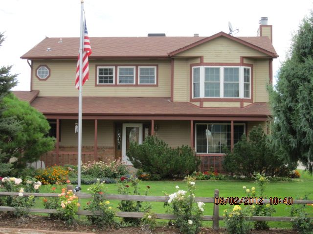
Building 1
| AccountNo | Building ID | Occupancy |
|---|---|---|
| R8980327 | 1 | Single Family Residential on Ag |
| ID | Type | NBHD | Occupancy | % Complete | Bedrooms | Baths |
|---|---|---|---|---|---|---|
| 1 | Residential | 3R2031 | Single Family Residential on Ag | 100 | 3 | 3.00 |
| ID | Exterior | Roof Cover | Interior | HVAC | Perimeter | Units | Unit Type | Make |
|---|---|---|---|---|---|---|---|---|
| 1 | Frame Hardboard | Composition Shingle | Drywall | Forced Air | 0 | 0 | NA | NA |
| ID | Square Ft | Condo SF | Total Basement SF | Finished Basement SF | Garage SF | Carport SF | Balcony SF | Porch SF |
|---|---|---|---|---|---|---|---|---|
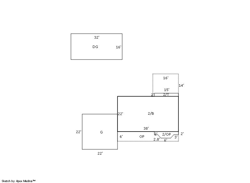
| 1 | 1,748 | 0 | 836 | 0 | 512 | 0 | 0 | 228 |
| ID | Built As | Square Ft | Year Built | Stories | Length | Width |
|---|---|---|---|---|---|---|
| 1.00 | 2 Story | 1,748 | 1988 | 2 | 0 | 0 |
| ID | Detail Type | Description | Units |
|---|---|---|---|
| 1 | Add On | Fireplace Wood | 1.00 |
| 1 | Add On | Heat Evaporative Coolers | 1.00 |
| 1 | Basement | Total Basement SF | 836.00 |
| 1 | Fixture | Full Bath | 1.00 |
| 1 | Fixture | Half Bath | 2.00 |
| 1 | Garage | Attached | 484.00 |
| 1 | Garage | Detached | 512.00 |
| 1 | Porch | Open Slab | 224.00 |
| 1 | Porch | Slab Roof Ceil | 228.00 |
| 1 | Rough In | Rough In | 2.00 |
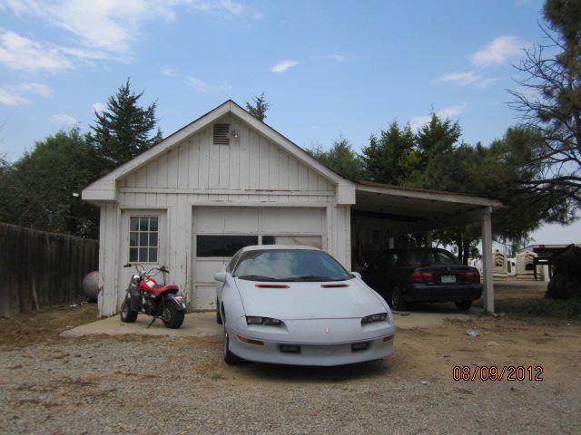
Building 2
| AccountNo | Building ID | Occupancy |
|---|---|---|
| R8980327 | 2 | Detached Garage |
| ID | Type | NBHD | Occupancy | % Complete | Bedrooms | Baths |
|---|---|---|---|---|---|---|
| 2 | Residential | 3R2031 | Detached Garage | 100 | 0 | 0.00 |
| ID | Exterior | Roof Cover | Interior | HVAC | Perimeter | Units | Unit Type | Make |
|---|---|---|---|---|---|---|---|---|
| 2 | Frame Hardboard | NA | NA | None | NA | 0 | NA | NA |
| ID | Square Ft | Condo SF | Total Basement SF | Finished Basement SF | Garage SF | Carport SF | Balcony SF | Porch SF |
|---|---|---|---|---|---|---|---|---|
| 2 | 660 | 0 | 0 | 0 | 0 | 0 | 0 | 0 |
| ID | Built As | Square Ft | Year Built | Stories | Length | Width |
|---|---|---|---|---|---|---|
| 2.00 | Detached Garage | 660 | 1950 | 1 | 0 | 0 |
No Additional Details for Building 2
| Account | Parcel | Account Type | Tax Year | Buildings | Actual Value | Local Govt Assessed Value | School Assessed Value |
|---|---|---|---|---|---|---|---|
| R8980327 | 131304201001 | Agricultural | 2026 | 2 | 439,100 | 33,230 | 36,520 |
| Type | Code | Description | Actual Value | Local Govt Assessed Value | School Assessed Value | Acres | Land SqFt |
|---|---|---|---|---|---|---|---|
| Improvement | 4277 | FARM/RANCH RESIDENCE-IMPS | 411,203 | 25,700 | 28,990 | 0.000 | 0 |
| Improvement | 4279 | FARM RANCH SUPPORT BLDGS | 26,757 | 7,220 | 7,220 | 0.000 | 0 |
| Land | 4117 | FLOOD IRRIGATED LAND-AGRICULTURAL | 1,140 | 310 | 310 | 1.216 | 52,987 |
| Totals | - | - | 439,100 | 33,230 | 36,520 | 1.216 | 52,987 |
Comparable sales for your Residential or Commercial property may be found using our SALES SEARCH TOOL
Values are updated annually on May 1st for Real Property and June 15th for Personal Property and Oil and Gas.
| Account | Parcel | Account Type | Tax Year | Buildings | Actual Value | Local Govt Assessed Value | School Assessed Value |
|---|---|---|---|---|---|---|---|
| R8980327 | 131304201001 | Agricultural | 2026 | 2 | 439,100 | 33,230 | 36,520 |
| Tax Area | District ID | District Name | Local Govt Mill Levy |
School Mill Levy |
Estimated Taxes |
|---|---|---|---|---|---|
| 5487 | 0900 | CARBON VALLEY REC | 4.427 | 0.000 | $147.11 |
| 5487 | 0406 | FIRESTONE TOWN | 6.805 | 0.000 | $226.13 |
| 5487 | 0507 | FREDERICK-FIRESTONE FIRE | 15.559 | 0.000 | $517.03 |
| 5487 | 1050 | HIGH PLAINS LIBRARY | 3.044 | 0.000 | $101.15 |
| 5487 | 1202 | LONGMONT CONSERVATION | 0.000 | 0.000 | $0.00 |
| 5487 | 0312 | LONGS PEAK WATER | 0.000 | 0.000 | $0.00 |
| 5487 | 0301 | NORTHERN COLORADO WATER (NCW) | 1.000 | 0.000 | $33.23 |
| 5487 | 0953 | NORTHERN FIRESTONE URBAN RENEWAL (NFURA) | 0.000 | 0.000 | $0.00 |
| 5487 | 0213 | SCHOOL DIST RE1J-LONGMONT | 0.000 | 57.717 | $2,107.82 |
| 5487 | 0303 | ST VRAIN LEFT HAND WATER (SVW) | 1.406 | 0.000 | $46.72 |
| 5487 | 0100 | WELD COUNTY | 15.956 | 0.000 | $530.22 |
| Total | - | - | 48.197 | 57.717 | $3,709.41 |
The estimate of tax is based on the prior year mill levy and the 2025 projected assessment rates. Mill levies and tax estimates will be updated yearly on December 22nd for the current year. Additional information can be found at https://assessor.weld.gov
- 2025 NOV

- 2024 NOV
- 2023 NOV
- 2022 (not available)
- 2021 (not available)
- 2020 (not available)
- 2019 (not available)