Account: R8981806
April 2, 2026
| Account | Parcel | Account Type | Tax Year | Buildings | Actual Value | Local Govt Assessed Value | School Assessed Value |
|---|---|---|---|---|---|---|---|
| R8981806 | 070713100060 | Agricultural | 2026 | 1 | 377,145 | 46,290 | 48,420 |
| Legal |
|---|
| PT E2 13 07 66 LOT B FAMILY FARM DIV FFD22-0021 |
| Subdivision | Block | Lot | Land Economic Area |
|---|---|---|---|
| AULT RURAL |
| Property Address | Property City | Section | Township | Range |
|---|---|---|---|---|
| 17482 HIGHWAY 14 | WELD | 13 | 07 | 66 |
| Account | Parcel | Account Type | Tax Year | Buildings | Actual Value | Local Govt Assessed Value | School Assessed Value |
|---|---|---|---|---|---|---|---|
| R8981806 | 070713100060 | Agricultural | 2026 | 1 | 377,145 | 46,290 | 48,420 |
| Account | Owner Name | Address |
|---|---|---|
| R8981806 | 136TH & HURON LLC | 5450 TIRRANNA CT FORT COLLINS, CO 805249385 |
| Account | Parcel | Account Type | Tax Year | Buildings | Actual Value | Local Govt Assessed Value | School Assessed Value |
|---|---|---|---|---|---|---|---|
| R8981806 | 070713100060 | Agricultural | 2026 | 1 | 377,145 | 46,290 | 48,420 |
| Reception | Rec Date | Type | Grantor | Grantee | Doc Fee | Sale Date | Sale Price |
|---|---|---|---|---|---|---|---|
| 4898826 | 05-17-2023 | RE | FFD22 0021 | FFD22 0021 | 0.00 | 05-12-2023 | 0 |
| 4905095 | 06-22-2023 | QCN | D DART RANCH INC | D DART RANCH INC | 0.00 | 06-22-2023 | 0 |
| 4944649 | 02-15-2024 | SURV | SURVEY | SURVEY | 0.00 | 10-23-2020 | 0 |
| 5019285 | 03-28-2025 | WD | D-DART RANCH INC | 136TH & HURON LLC | 155.00 | 03-27-2025 | 1,550,000 |
*If the hyperlink for the reception number does not work, try a manual search in the Clerk and Recorder records. Use the Grantor or Grantee in your search.
| Account | Parcel | Account Type | Tax Year | Buildings | Actual Value | Local Govt Assessed Value | School Assessed Value |
|---|---|---|---|---|---|---|---|
| R8981806 | 070713100060 | Agricultural | 2026 | 1 | 377,145 | 46,290 | 48,420 |
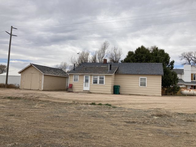
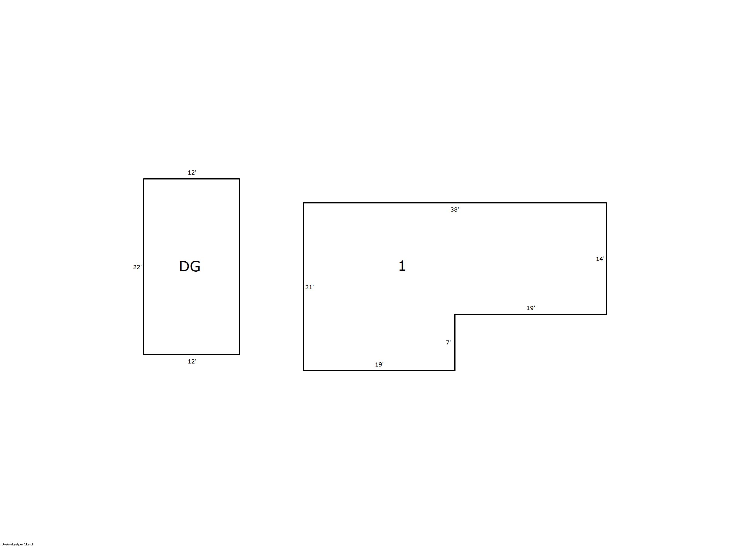
Building 1
| AccountNo | Building ID | Occupancy |
|---|---|---|
| R8981806 | 1 | Single Family Residential on Ag |
| ID | Type | NBHD | Occupancy | % Complete | Bedrooms | Baths |
|---|---|---|---|---|---|---|
| 1 | Residential | 9R0015 | Single Family Residential on Ag | 100 | 1 | 1.00 |
| ID | Exterior | Roof Cover | Interior | HVAC | Perimeter | Units | Unit Type | Make |
|---|---|---|---|---|---|---|---|---|
| 1 | Frame Siding | Composition Shingle | Plaster | Forced Air | 118 | 0 | NA | NA |
| ID | Square Ft | Condo SF | Total Basement SF | Finished Basement SF | Garage SF | Carport SF | Balcony SF | Porch SF |
|---|---|---|---|---|---|---|---|---|
| 1 | 665 | 0 | 0 | 0 | 264 | 0 | 0 | 0 |
| ID | Built As | Square Ft | Year Built | Stories | Length | Width |
|---|---|---|---|---|---|---|
| 1.00 | Ranch 1 Story | 665 | 1914 | 1 | 0 | 0 |
| ID | Detail Type | Description | Units |
|---|---|---|---|
| 1 | Fixture | Full Bath | 1.00 |
| 1 | Garage | Detached | 264.00 |
| Account | Parcel | Account Type | Tax Year | Buildings | Actual Value | Local Govt Assessed Value | School Assessed Value |
|---|---|---|---|---|---|---|---|
| R8981806 | 070713100060 | Agricultural | 2026 | 1 | 377,145 | 46,290 | 48,420 |
| Type | Code | Description | Actual Value | Local Govt Assessed Value | School Assessed Value | Acres | Land SqFt |
|---|---|---|---|---|---|---|---|
| Improvement | 4277 | FARM/RANCH RESIDENCE-IMPS | 267,708 | 16,730 | 18,870 | 0.000 | 0 |
| Land | 4107 | SPRINKLER IRRIGATED LAND | 109,426 | 29,550 | 29,550 | 149.940 | 6,531,386 |
| Land | 4167 | WASTE LAND | 11 | 10 | 0 | 1.590 | 69,260 |
| Totals | - | - | 377,145 | 46,290 | 48,420 | 151.530 | 6,600,646 |
Comparable sales for your Residential or Commercial property may be found using our SALES SEARCH TOOL
Values are updated annually on May 1st for Real Property and June 15th for Personal Property and Oil and Gas.
| Account | Parcel | Account Type | Tax Year | Buildings | Actual Value | Local Govt Assessed Value | School Assessed Value |
|---|---|---|---|---|---|---|---|
| R8981806 | 070713100060 | Agricultural | 2026 | 1 | 377,145 | 46,290 | 48,420 |
| Tax Area | District ID | District Name | Local Govt Mill Levy |
School Mill Levy |
Estimated Taxes |
|---|---|---|---|---|---|
| 0919 | 0700 | AIMS JUNIOR COLLEGE | 6.313 | 0.000 | $292.23 |
| 0919 | 0501 | AULT FIRE | 7.266 | 0.000 | $336.34 |
| 0919 | 1050 | HIGH PLAINS LIBRARY | 3.044 | 0.000 | $140.91 |
| 0919 | 0304 | NORTH WELD COUNTY WATER (NWC) | 0.000 | 0.000 | $0.00 |
| 0919 | 0301 | NORTHERN COLORADO WATER (NCW) | 1.000 | 0.000 | $46.29 |
| 0919 | 0209 | SCHOOL DIST RE9-AULT | 0.000 | 34.176 | $1,654.80 |
| 0919 | 0100 | WELD COUNTY | 15.956 | 0.000 | $738.60 |
| 0919 | 1200 | WEST GREELEY CONSERVATION | 0.414 | 0.000 | $19.16 |
| Total | - | - | 33.993 | 34.176 | $3,228.34 |
The estimate of tax is based on the prior year mill levy and the 2025 projected assessment rates. Mill levies and tax estimates will be updated yearly on December 22nd for the current year. Additional information can be found at https://assessor.weld.gov
- 2025 NOV

- 2024 NOV
- 2023 NOV
- 2022 (not available)
- 2021 (not available)
- 2020 (not available)
- 2019 (not available)