Account: R8985666
April 2, 2026
| Account | Parcel | Account Type | Tax Year | Buildings | Actual Value | Local Govt Assessed Value | School Assessed Value |
|---|---|---|---|---|---|---|---|
| R8985666 | 146718351001 | Commercial | 2026 | 1 | 609,000 | 164,430 | 164,430 |
| Legal |
|---|
| Lot 3B ROCKTON AMD NO. 2 TOWN OF ERIE |
| Subdivision | Block | Lot | Land Economic Area |
|---|---|---|---|
| ROCKTON AMD NO. 2 TOWN OF ERIE | 3B | ERIE COMMERCIAL |
| Property Address | Property City | Section | Township | Range |
|---|---|---|---|---|
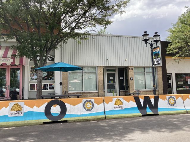
| 512 BRIGGS ST | ERIE | 18 | 01 | 68 |
| Account | Parcel | Account Type | Tax Year | Buildings | Actual Value | Local Govt Assessed Value | School Assessed Value |
|---|---|---|---|---|---|---|---|
| R8985666 | 146718351001 | Commercial | 2026 | 1 | 609,000 | 164,430 | 164,430 |
| Account | Owner Name | Address |
|---|---|---|
| R8985666 | 512 BRIGGS LLC | 474 S TAYLOR AVE UNIT B LOUISVILLE, CO 800279748 |
| Account | Parcel | Account Type | Tax Year | Buildings | Actual Value | Local Govt Assessed Value | School Assessed Value |
|---|---|---|---|---|---|---|---|
| R8985666 | 146718351001 | Commercial | 2026 | 1 | 609,000 | 164,430 | 164,430 |
| Reception | Rec Date | Type | Grantor | Grantee | Doc Fee | Sale Date | Sale Price |
|---|---|---|---|---|---|---|---|
| 4951844 | 03-29-2024 | PLT | ROCKTON AMD NO. 2 TOWN OF ERIE | ROCKTON AMD NO. 2 TOWN OF ERIE | 0.00 | 03-21-2024 | 0 |
| 4953231 | 04-05-2024 | SWD | ROCKTON 524 LLC | 512 BRIGGS LLC | 63.00 | 04-04-2024 | 630,000 |
| 4953646 | 04-08-2024 | SURV | SURVEY | SURVEY | 0.00 | 03-29-2024 | 0 |
*If the hyperlink for the reception number does not work, try a manual search in the Clerk and Recorder records. Use the Grantor or Grantee in your search.
| Account | Parcel | Account Type | Tax Year | Buildings | Actual Value | Local Govt Assessed Value | School Assessed Value |
|---|---|---|---|---|---|---|---|
| R8985666 | 146718351001 | Commercial | 2026 | 1 | 609,000 | 164,430 | 164,430 |
Building 1
| AccountNo | Building ID | Occupancy |
|---|---|---|
| R8985666 | 1 | Retail |
| ID | Type | NBHD | Occupancy | % Complete | Bedrooms | Baths |
|---|---|---|---|---|---|---|
| 1 | Commercial | 3901 | Retail | 100 | 0 | 0.00 |
| ID | Exterior | Roof Cover | Interior | HVAC | Perimeter | Units | Unit Type | Make |
|---|---|---|---|---|---|---|---|---|
| 1 | NA | NA | NA | Package Unit | 187 | 0 | NA | NA |
| ID | Square Ft | Condo SF | Total Basement SF | Finished Basement SF | Garage SF | Carport SF | Balcony SF | Porch SF |
|---|---|---|---|---|---|---|---|---|
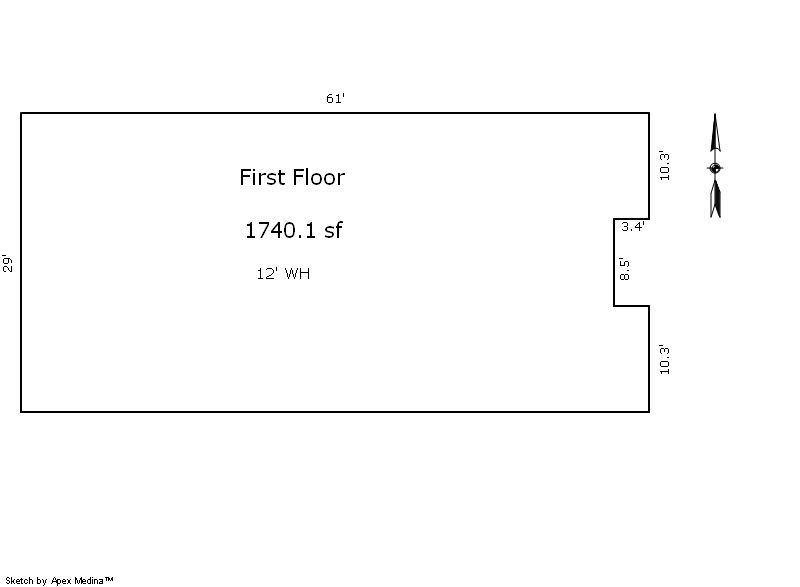
| 1 | 1,740 | 0 | 0 | 0 | 0 | 0 | 0 | 0 |
| ID | Built As | Square Ft | Year Built | Stories | Length | Width |
|---|---|---|---|---|---|---|
| 1.00 | Bank | 1,740 | 1918 | 1 | 0 | 0 |
No Additional Details for Building 1
| Account | Parcel | Account Type | Tax Year | Buildings | Actual Value | Local Govt Assessed Value | School Assessed Value |
|---|---|---|---|---|---|---|---|
| R8985666 | 146718351001 | Commercial | 2026 | 1 | 609,000 | 164,430 | 164,430 |
| Type | Code | Description | Actual Value | Local Govt Assessed Value | School Assessed Value | Acres | Land SqFt |
|---|---|---|---|---|---|---|---|
| Improvement | 2230 | SPECIAL PURPOSE-IMPROVEMENTS | 540,885 | 146,040 | 146,040 | 0.000 | 0 |
| Land | 2130 | SPECIAL PURPOSE-LAND | 68,115 | 18,390 | 18,390 | 0.104 | 4,541 |
| Totals | - | - | 609,000 | 164,430 | 164,430 | 0.104 | 4,541 |
Comparable sales for your Residential or Commercial property may be found using our SALES SEARCH TOOL
Values are updated annually on May 1st for Real Property and June 15th for Personal Property and Oil and Gas.
| Account | Parcel | Account Type | Tax Year | Buildings | Actual Value | Local Govt Assessed Value | School Assessed Value |
|---|---|---|---|---|---|---|---|
| R8985666 | 146718351001 | Commercial | 2026 | 1 | 609,000 | 164,430 | 164,430 |
| Tax Area | District ID | District Name | Local Govt Mill Levy |
School Mill Levy |
Estimated Taxes |
|---|---|---|---|---|---|
| 5379 | 0949 | ERIE HISTORIC URBAN RENEWAL | 0.000 | 0.000 | $0.00 |
| 5379 | 0404 | ERIE TOWN | 13.237 | 0.000 | $2,176.56 |
| 5379 | 1050 | HIGH PLAINS LIBRARY | 3.044 | 0.000 | $500.52 |
| 5379 | 0512 | MOUNTAIN VIEW FIRE PROTECTION DISTRICT | 16.342 | 0.000 | $2,687.12 |
| 5379 | 0301 | NORTHERN COLORADO WATER (NCW) | 1.000 | 0.000 | $164.43 |
| 5379 | 1360 | RTD | 0.000 | 0.000 | $0.00 |
| 5379 | 0213 | SCHOOL DIST RE1J-LONGMONT | 0.000 | 57.717 | $9,490.41 |
| 5379 | 0100 | WELD COUNTY | 15.956 | 0.000 | $2,623.65 |
| Total | - | - | 49.579 | 57.717 | $17,642.68 |
The estimate of tax is based on the prior year mill levy and the 2025 projected assessment rates. Mill levies and tax estimates will be updated yearly on December 22nd for the current year. Additional information can be found at https://assessor.weld.gov
- 2025 NOV

- 2024 NOV
- 2023 (not available)
- 2022 (not available)
- 2021 (not available)
- 2020 (not available)
- 2019 (not available)